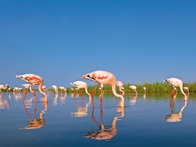
How is the habitat of Tadoba National Park?


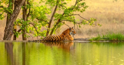
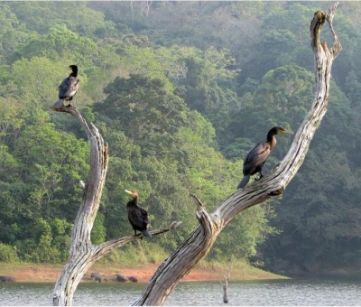
Located in Maharashtra's Chandrapur district, Tadoba-Andhari Tiger Reserve comprises Tadoba National Park and Andhari Wildlife Sanctuary. Maharashtra's oldest national park, Tadoba was created in 1955. Covering more than 600 sq.km., the area's topography supports diverse habitats, including open canopy grasslands, stony grasslands along small hillocks, semi-deciduous riparian forest, perennial and seasonal streams, wetlands, and agricultural lands. All these make the region ideal for several species of birds, animals and reptiles to call it their home. A study conducted a few years ago recorded the presence of over 250 species of birds, including five endemic to India and more than 15 categorised as "threatened” in the International Union for Conservation of Nature's Red List. The region also supports more than 70 species of butterflies.


Wildlife


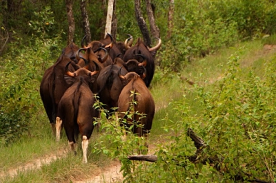
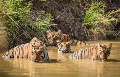
Pochards, shovelers, teals, pintails, quails, francolins, grebes, pigeons, doves, nightjars, sandgrouses, swifts, cuckoos, malkohas, storks, herons, egrets, bitterns, cormorants, ibises, darters, stilts, lapwings, jacanas, terns, sandpipers, pratincoles, kites, eagles, harriers, vultures, buzzards, buttonquails, owls, owlets, hornbills, woodpeckers, barbets, parakeets, orioles, drongoes, fantails, shrikes, flowerpeckers, munias, swallows, martins, bulbuls, warblers, babblers, starlings, mynas and flycatchers are among the bird species found in the region. In addition to the keystone species, the Bengal tiger, the area is a habitat for mammals such as leopard, Indian wild dog, sloth bear, gaur, the Indian fox, rusty spotted cat, honey badger, small Indian civet and ungulates such as sambar, spotted deer, barking deer, nilgai and four-horned antelope. Reptiles from the area include marsh crocodiles, Indian python, common Indian monitor, terrapins, Indian star tortoise, Indian cobra and Russel’s viper.


Good news, but...


In 2019, a report released by the Parliamentary Standing Committee on Science and Technology, Environment and forests said that Tadoba witnessed two-fold increase – from 86,557 to 1.73 lakh - in tourist numbers between 2012-13 and 2017-18. This also meant an increase in revenue - Rs. 6.78 crore from Rs. 1.75 crore, a whopping 280 % increase. Such revenues are crucial for the upkeep of the region. Another comforting factor is that the Reserve was one of the few in the country that saw an increase in tiger numbers a few years ago. This too has been encouraging news for tourism since increased tiger numbers could translate to increased sighting, and in turn, more tourists. However, increase in tourists may not always be good news. Here's why.


Only a few months ago did the government propose to offer ecotourism in the Reserve's buffer zone to boost local economy. Since the zone includes more than 75 villages, the step aims to rope them in for conservation activities and sensitise them to human-animal conflict. With their knowledge of the region, the villagers could become drivers, guides, etc. While this is certainly encouraging, it is not without concerns. Among the activities planned for ecotourism include those such as adventure sports. Since such activities require experts, villagers and activists are worried that gradually private players could take over the region, leaving behind locals to suffer, defeating the very purpose it hoped to achieve.


Picture Credit : Google


What is G20?


G20 was in the news recently with its two-day summit hosted virtually by Saudi Arabia in Riyadh.


G20 and its members


The G20 (or the Group of Twenty) is an informal group of 19 countries and the European Union, a combination of the world's largest advanced and emerging economies. Formed in 1999, the G20 forum regularly meets to coordinate global policy on economic growth, international trade, health, climate and other issues. The G20 does not have a permanent headquarters and its presidency rotates annually.


The G20 members are Argentina, Australia, Brazil, Canada, China, France, Germany, India, Indonesia, Italy Japan, Mexico, Russia, Saudi Arabia, South Africa, South Korea, Turkey, the U.K., the U.S. and the European Union. The G20 economies together account for nearly 80% of the world's economic output, two-thirds of the global population, and about half of the world's land area.


Its origin


The G20 was established in December 1999 in response to the financial crises faced by a number of countries in the 1990s with the aim of uniting the world around promoting global financial stability. There was also the need to create a more inclusive body with greater representation. What began as a regular forum for finance ministers and central bank governors turned into a key summit in 2008 when the heads of State and government came together for the first time in Washington to discuss global economy as well as other challenges facing the world. Ever since, the leaders have been meeting annually. A series of G20 ministerial events takes place during a year.


Its objectives


The G20 summit is focused on several key issues such as achieving global economic stability, sustainable growth, prevention of future financial crises, putting in place regulatory mechanisms and action against climate change. The two-day summit concludes with a joint statement issued by the members committing themselves to action. It is significant to note that the resolutions of the G20 are not legally binding, but they do influence the policies of the member countries.


Picture Credit : Google


Why does the berg A68A matter?


Satellites have been closely monitoring the movement of the world's largest iceberg, A68A, since it broke off from the Larsen C ice shelf on the east coast of the Antarctic Peninsula in 2017. Measuring 4,200 sq.km. in size, it had been slowly inching north until 2020, when an ocean current quickly propelled it into the Southern Atlantic Ocean and was set on a collision course with a sub-Antarctic island called South Georgia in South Atlantic Ocean. Mid- December, when it was about 75 km from the island, it split into two, as scientists had predicted earlier. The new iceberg, named A68D, moved further away from A68A, while the latter marched on. It is common for icebergs to fracture when they are under the influence of the ocean currents. In the last three years, chunks of A68A have broken off creating icebergs A68B and A68C. But what is worrying is the impact the iceberg could have on the South Georgia island, which is a haven for millions of penguins, seals and whales.


This has prompted a team of scientists at the British Antarctic Survey to set off on a research mission this month to find out more about the giant iceberg A68A and the risks it poses to the island.


What is an iceberg? Why does the berg A68A matter?


What is an iceberg?


An iceberg is ice that broke off from glaciers or ice shelves or larger icebergs and is floating in open water. This process of breaking off is called calving. To be classified as an iceberg, the height of the ice must be greater than 16 feet above sentenced the thickness must be 98-164 feet, according to their agency National Oceanic and Atmospheric Administration. Icebergs are made of frozen freshwater. Most of the mass of an iceberg lies below the surface of the water, which is dangerous to ships. The North Atlantic and the cold waters surrounding Antarctica are home to most of the icebergs on Earth.


Why are scientists worried?


  • South Georgia is home to millions of gentoo, macaroni, and king penguins and sea lions, nesting albatrosses, and petrels. A small population of endangered blue whales is also found here. The island is also incredibly diverse on the seabeds, harbouring molluscs, crustaceans, sponges and other life. It’s a diversity almost equivalent to the Galapagos, say scientists.

  • Researchers fear that as the iceberg A68A closes in on the wildlife-rich island, it could grind into the seabed, disrupting underwater ecosystems.

  • If the iceberg gets lodged in the island's shoreline it could stay there for years and decades. That would cut access to the ocean for penguin, and seal parents, who make trips into the water to collect fish and krill for their young.

  • The waters around South Georgia are about 4 degree C, but in the vicinity of the iceberg the temperature could fall to a couple of degrees more. It could lead to the release of billions of tonnes of fresh water from iceberg into the region, ** which can devastate the ecosystem.


Is global warming a reason?


Though warming did not directly cause the break off of iceberg A68A, scientists draw our attention to its influence on ice shelves in the region. They found that about 60 % of the ice shelf area in Antarctica is vulnerable to a process called hydrofracturing, in which meltwater seeps into the shelves’ crevasses (cracks in glaciers), some of which are hundreds of metres deep, and trigger collapse. The collapse of Larsen B iceberg in the northern tip of the Antarctic peninsula in 2002 is attributed to hydrofracturing. Warming caused meltwater ponds to form on the surface of Larsen B, and water percolating down through the ice led to the shattering of the shelf into icebergs. More ice shelves could disintegrate in similar fashion, warn scientists. .


The Antarctic Peninsula is one of the fastest warming regions on Earth, and the ice shelves along its eastern coast have been apart. The Larsen A ice shelf, near the northern tip of the peninsula, collapsed in 1995. Its neighbour Larsen B followed suit in 2002. The Larsen C, is the largest of the three, broke off in 2017.


Picture Credit : Google


What is Rann of Kutch famous for?


The Wild Ass Sanctuary spans nearly 5,000 sq km. in Gujarat's Little Rann of Kutch. Home to the third largest population of these animals in the world, the area is believed to be nurturing at least a few thousands of these mammals. Usually moving in large groups, these animals can be spotted throughout the year in this region. Due to its proximity to the Rann of Kutch and the variety in the region's vegetation, the sanctuary hosts more than 30 species of rare and endangered animals, and over 90 species of invertebrates. In fact, the sanctuary also lies on the migratory route of several hundred birds that travel from as far as Europe, Russia and Egypt.


Wildlife


More than 350 species of birds can be spotted in the region, and these include ducks, geese, quails francolins, flamingoes, grebes, doves, pigeons, sandgrouses, nightjars, swifts, coucals, malkohas, cuckoos, koels, crakes, cranes, bustards, storks, pelicans, herons, egrets, ibises, cormorants, thick knees, plovers, lapwings, godwits, sandpipers, pratincoles, gulls, terns, kites, eagles, buzzards, vultures, owls, woodpeckers, bee-eaters, rollers, kingfishers, falcons, parakeets, orioles, drongos, shrikes, flowerpeckers, sunbirds, weavers, pipits, wagtails, buntings, larks, prinias, warblers, swallows, martins, bulbuls, starlings, flycatchers and wheatears. In addition to the wild ass, the place hosts several other animals, including chinkara, nilgai or blue bull, black buck, wild boar, Indian wolf, jackal, striped hyna, desert hare, desert cat, pangolin, porcupine, Indian fox, mongoose, and jungle cat.


There's good news...


In 2015, the census of the wild ass showed that the total number of these ungulates was a little short of 4.500. A similar exercise conducted in March 2020 showed that the Umber stood at a little over 6,000 - showing a spike of 30 % in just five years. This is particularly encouraging, considering the species had a worrying history. Due to the outbreak of diseases, the number of these mammals had fallen to a mere 700 back in the 1960s. The population today points to a successful and concerted conservation effort over decades. It also points to the need to be mindful of the continuing threats faced by the wild ass, found in the wild only in this part of the country.


... but threats persist


While a growing population is comforting to hear, the threats that these animals face remain a concern. Since the paths of these animals cross those of domestic livestock that herders take out for grazing, the chance of a disease outbreak and the animals contracting it are high. Further, water carrying pesticide and fertilizer from farmlands outside the sanctuary enter the region, with potential to harm animals that could drink the polluted water. The increasing number of salt pans and illegal mining in the region are additional threats to the sanctuary.


Picture Credit : Google


What is the polar vortex?


Scientists have wanted that a weather phenomenon called the polar vortex could bring frigid temperatures and stormy weather to the Northern Hemisphere this year too. The phenomenon is a fairly Common occurrence and meteorologists keep a dose watch on the stratosphere for signals on potential Arctic air invasions and predict their severity,


The polar vortex is a large area of low pressure that consistently overlies the North and the South poles. They are called vortexes because of the mass of cold, dense air that spins counter clockwise like a hurricane. Sometimes during winter in the Northern Hemisphere, this vortex becomes weak and expands, sending the Arctic cold air southward into the United States, Europe and Asia. Ironically, the cause of this chill is a sudden heat seeping into the whirling currents. That is, the temperature surge in the stratosphere, the layer of the atmosphere, which is located between 10 and 50 km above the ground leads to the weakening of the polar vortex. And it wobbles off the pole.


The polar vortex is capable of delivering subzero temperatures for several days together In the recent past, the 2014 polar vortex is remembered as it gave rise to record low temperatures which lasted until March.


Some scientists suggest that warming in the Arctic and climate change could make the polar vortex unstable in the coming years, leading to potentially serious consequences.


Picture Credit : Google


What type of structure is the Burj Khalifa?


There are few buildings in the world that share the kind of popularity that the Burj Khalifa enjoys. A towering skyscraper in Dubai, United Arab Emirates, the Burj Khalifa's total height is 829.8 m and its roof height (excluding antenna) is 828 m. That makes it the tallest structure and building in the world, since its official launch ceremony in January 2010.


The spider lily


Such a massive structure is naturally an engineering Marvel. What makes it even more special is its design. The Burj Khalifa has a triple-lobed footprint, an abstraction of the Hymenocallis flower. The Hymenocallis or spider lily is a regional desert flower from which the architects drew inspiration for the iconic tower's design. While this beautiful choice maximises window viewing, the architects didn't go for it purely for Aesthetic or ornamental reasons. This design ensures that the tower is composed of different features that are arranged around a central core. This provides for an inherently stable configuration, vital for super-tall buildings.


Biomimetics


The modular, Y-shaped structure has setbacks along each of its three wings and affords lateral bending resistance. The central core, which emerges on top and culminates in a sculpted spire, provides strong torsional resistance.


The Burj Khalifa thus serves as a great illustration of biomimetics or biomimicry - the science or art of emulating systems and elements of nature in order to solve complex human problems.


Picture Credit : Google


Why Ranthambore Tiger Reserve is popular?


Spanning more than 1,500 sq km. the Ranthambore Tiger Reserve in Rajasthan comprises a national park of the same name and two sanctuaries - Sawai Mansingh and Keladevi Covered in grasslands and dense dry deciduous forests interspersed with rivulets and seasonal streams, small wonder it is home to over 200 species of birds and several reptiles, amphibians and mammals, with the tiger as its apex predator.


Wildlife


Francolins, quails, pochards, buttonquails, barbets, nightjars, cranes, sandgrouses, snipes, redshanks, sandpipers, jacanas, thickknees, stints, plovers, lapwings gulls, terns, buzzards, harriers, grebes, cormorants, bitterns, ibises, pelicans, storks, shrikes, minivets, drongos, flycatchers, thrushes, robins, bushchats, wheatears, mynas, starlings, tits, swallows, bulbuls, prinias, warblers, babblers, whitethroats, larks, sunbirds, wagtails, pipits, munias and buntings are found here. Tiger, leopard, jungle cat sloth bear wild boar, black buck, caracal jackal, fox, striped hyena mongoose,  Indian wolf, chinkara, chital, otter, honey badger, pangolin,  Asian palm civet, sambar, nilgai black- naped hare rhesus macaque and grey langur can be spotted here. Reptiles such as saltwater crocodile and mangrove monitor, and several species of snakes, including banded krait saw scaled viper and Indian cobra call the region home.


The big fight


The reserve is quite vast, spreading across more than 1,500 sq km. But this includes the more than 1,000 sq km of buffer 201, leaving the tigers with a little more than 500 sq km for use. However, since tigers are highly territorial and need a lot of room for themselves, Ranthambore faces an unusual problem - the problem of plenty. There are more than 70 tigers in the reserve, and each tiger is said to require about 10 sq km. forcing the big cats to fight for space. In the last few years, a few tigers have died in territorial fights. Not just that. When space becomes scarce, they venture out of their territory and into conflict - with humans. And most of these encounters do not end well for either. In the past a few tigers from Ranthambore have been relocated to other reserves such as Sariska. However, with the habitats of tigers shrinking, the tiger number is something to be watched closely.


The power of local knowledge


The forests of the reserve were earlier the hunting grounds of the kings. Today through villagers on the fringes the forests and its habitants are protected, says a media report Nearly 50 members of the Village Wildlife Volunteers programme not only protect and conserve the forests but also use their voice to rope in more people towards this cause. This has helped not just in the capture of poachers but also in keeping the forest department informed about the movement of tigers and the presence of other animals. Most invaluable is the knowledge of the villagers about local habitats and wildlife, which educates personnel in the department. For instance, the villagers helped discover "a breeding population of about 30 gharials, a critically endangered animal, in a river near Ranthambore”. They also assist researchers in the field. This story underscores how invaluable the role of locals in the protection of forest areas is.


Picture Credit : Google


What’s permafrost?


Siberia’s mysterious craters


In July 2020, a Russian TV crew flying over the Yamal peninsula in Siberia spotted a huge crater at least 160 feet deep and 65 feet wide. Scientists who went to investigate it found chunks of ice and rock thrown hundreds of metres away from the epicentre. This crater is just the 17h discovered in the Siberian Arctic, after the first one in 2014. Are they the result of a meteorite strike, a missile blast, permafrost or simply land cave-ins? So far, it remains unclear. But scientists have come up with their theories.


Permafrost make-up two-thirds of Sibera. It is nothing but soil that has remained frozen for years or centuries under topsoil. It contains carbon-rich organic matter, including the remains of plants and animals that died and froze without decaying.


Permafrost covers about 24% of the exposed landmass of the Northern Hemisphere – parts of Siberia, the Tibetan Plateau, Alaska, Northern Canada, Greenland, and parts of Scandinavia.


What do scientists say?


Result of cryovolcanism


In 2018, scientists proposed that the blasts are a form of cryovolcanism, in which eruptions spew out frosty mud or slush rather than molten rocks. Scientists believe the craters form from blasts of methane and carbon dioxide gas trapped within the Siberian permafrost.


How does it work? Natural gas abounds in western Siberia, and some of it likely percolates up along cracks and porous zones in the ground into the mushy layer called taliks, under pressure. (Taliks are surrounded by permafrost). The gas accumulation also comes from methane or carbon dioxide that microbes release after consuming the organic matter in the permafrost. It is either because of the mounting gaseous pressure or the destabilisation of the overlying ice cap that the system explodes, spewing the slurry across the surface and leaving a steep crater behind.


Rising temperature, thawing permafrost


The other reason could be the instability of permafrost, say scientists. Temperature at the Arctic has been significantly rising. In fact, this year, the small town of Verkhoyansk, Russia, reached a scorching 100.4 degrees Fahrenheit.


Rising temperature causes permafrost to thaw, triggering massive changes in the region’s landscape and ecology. Scientists observe that every summer, the thawing has been intensifying.


When frozen-solid, melts, it can collapse in many ways, creating landslides, lakes, pits and even underground tunnels. It may also contribute to more frequent blasts and formation of craters.


Picture Credit : Google


Do dunes communicate with one another?


A pile of sand exposed to wind or water flow forms a dune shape and starts moving downstream along with the flow. Be it in deserts, river bottoms or sea beds, dunes always appear in groups, often forming prominent patterns.


While it is well established that dunes migrate, it hasn’t been completely understood if and how dunes within a group interact with each other. There have been a number of theories to try and explain this. One suggests a snowballing technique where duns keep colliding and exchanging mass until they achieve a certain condition. These theories, however, have to be validated, either through experiments, or by observing it in nature.


Earlier this year, scientists from the University of Cambridge came up with an alternative theory. They found that sand dunes were able to ‘communicate’ with one another, interacting and repelling their neighbours even as they moved.


They came to this conclusion by using an experimental dune racetrack. While water-filled flumes artificial channel conveying water) have been common tools in study the movement of sand dunes in a lab setting, scientists in this experiment built a circular flume to study the dunes for hours at a time.


Even though this set-up was implemented to speed up the data collection process, they quickly realised that dunes were interacting with each other with time. Having started with two identical dunes, they noticed that the front dune affected the properties of the second dune. As the experiment went on the two dunes went further apart, until they achieved equilibrium on opposite ends of the circular flume.


These are still early days and there are plenty of steps still left to understand examples dune migration. Clusters of dunes would have to be observed for long periods of time through satellite imagery or other means to produce evidence. As long-term dune migration increases desertification, threatens shipping channels and can even bury infrastructure, they are bound to be researched further in the future.


Picture Credit : Google


Why Periyar Tiger Reserve is famous?


Spanning over 725 sq. km., the Periyar Tiger Reserve in Kerala is one of the rich biodiversity hotspots of the Western Ghats. Comprising a range of tropical evergreen and semi-evergreen forests, moist deciduous forests, grasslands and eucalyptus plantations, it is amply nourished by rivers such as the Periyar running through the region. The reserve is a green zone that's home to more than a 100 varieties each of grasses and orchids - perfect to welcome several species of mammals, reptiles, amphibians, birds and butterflies. The region also hosts a large number of Asiatic elephants, making it one of the most significant elephant reserves of the country.


Wildlife


Garganeys, little grebes, nightjars, swift, coucal, malkohas, crakes, bitterns, cormorants, snipes, sandpipers, harriers, hornbills, woodpeckers, barbets, bee-eaters, falcons, minivets, orioles, woodshrikes, shrikes, treepies, flowerpeckers, sunbirds, leaf birds, munias, pipits, wagtails, tits, larks, prinias, warblers, swallows, babblers, starlings, nuthatches, flycatchers, robins and thrushes are among the species of birds that can be seen here. In addition to the Royal Bengal tiger and the Asiatic elephant, one can spot mammals such as leopard, bison, sambar, barking deer, Indian wild dog, wild boar, Nilgiri marten, Nilgiri langur and otter. A variety of reptiles such as cobra, viper, krait, and Indian monitor lizard, and amphibians such as frogs and toads too are found in the region.


Cause for concern


report by the Comptroller and Auditor General of India in 2019 A said that the Travancore Devaswom Board (TDB), an autonomous body that manages 1,248 temples including the Sabarimala Ayappa Temple, has been violating the Master Plan for Sabarimala for over a decade. This is affecting the ecology of the Periyar Tiger Reserve". The report on the implementation of Wildlife Protection Act in Kerala says that the "impact of Sabarimala pilgrimage ranked first in the list of 18 major threats identified by Periyar Tiger Reserve authorities in Tiger Conservation Plan". It added that due to the lack of drainage facilities, overflowing waste water and sewage was mixing with the rivers in the region. Further, electric lines had not been laid underground, and the existing "overhead cables without insulation" could pose a threat to wildlife species in the area.


Poachers to protectors


The Periyar Tiger Reserve is an example of an unusual success story. According to Mongabay, a conservation and environment news and features service, the story begins towards the end of the 20th Century, when a forest brigand operating near the reserve is captured. He led a 23-member gang of poachers and sandalwood smugglers. And was willing to give it all up if they were assured of a job with a steady income. However, back then there was no provision to include poachers and smugglers in forest management. Several discussions happened and a few years passed before Vidiyal Vanapathukappu Sangam was set up. It would be the country's first eco-development committee constituted solely of former poachers and sandalwood smugglers"". The group underwent training and was exposed to the need for conservation. It's been 17 years since. The members have helped crack at least "230 cases of poaching and smuggling". In addition to patrolling, they also double up as tourist guides and elephant safari providers. Most importantly, they have managed to educate their children - some are postgraduates today! The success of this model has been so encouraging that several other reserves and sanctuaries too have emulated it.


Picture Credit : Google


What is the rarest naturally occurring element in Earth's crust?


Astatine is the rarest, naturally occurring element in the Earth's crust, occurring only as the decay product of various heavier elements. There are only about 25 grams of naturally-occurring astatine in Earth's crust at any given time. It is a radioactive chemical element with symbol At and atomic number 85. It is the heaviest known halogen (a non-metal), but it has more metallic character than other elements in the halogen group.


The bulk properties of astatine are not known with certainty. Many of them have been estimated based on the element's position on the periodic table as a heavier analog of iodine, and a member of the halogens (the group of elements including fluorine, chlorine, bromine, and iodine). Astatine is likely to have a dark or lustrous appearance and may be a semiconductor or possibly a metal; it probably has a higher melting point than that of iodine. Chemically, several anionic species of astatine are known and most of its compounds resemble those of iodine. It also shows some metallic behavior, including being able to form a stable monatomic cation in aqueous solution (unlike the lighter halogens).


Picture Credit : Google


Why Nilgiri Biosphere Reserve is famous?


Spanning nearly 350 sq. km in Kerala, the Wayanad Wildlife Sanctuary is an integral part of the Nilgiri Biosphere Reserve. It is contiguous with the protected areas of Nagarhole and Bandipur of Karnataka on one side and Mudumalai of Tamil Nadu on another. Rich in biodiversity, the sanctuary is marked by moist deciduous forests, semi-evergreen forests and plantations of teak, eucalyptus. etc. The region teems with wildlife, including more than 200 species of birds, 40 species of mammals, over 30 types of amphibians, fishes, butterflies and dragonflies. This includes many endangered, threatened and rare species too. The perennial water resources in the sanctuary add to the abundance of wildlife that are dependent on them, especially in summer. The sanctuary is part of a tiger reserve and has one of the highest recorded populations of the Asiatic elephant.


Wildlife


Cormorants, herons, egrets, bitterns, storks, eagles, kites, vultures, buzzards, lapwings, jacanas, pigeons, doves, parakeets, cuckoos, owls, coucals, nightjars, swifts, bulbuls, minivets, shrikes, treepies, drongos, mynas, orioles, swallows, woodpeckers, barbets, hornbills, bee-eaters, kingfishers, babblers, bulbuls, flycatchers, warblers, thrushes, nuthatches, wagtails, flowerpeckers, sunbirds and munias can be spotted here. Asiatic elephant, tiger, leopard, common langur, four-horned antelope, mouse deer, sambar, barking deer, porcupine, mongoose, small Indian civet, chital, common giant flying squirrel, gaur, pangolin, hare, sloth bear, slender loris, wild boar, jungle cat, leopard cat and Indian flying fox are among the mammals found in the region.


Perils for Wayanad


  • Since plantation is dominant in the Wayanad region, so is the widespread use of chemical fertilizers and pesticides. Unfortunately, this has resulted in irreparable damage to the area's fragile ecosystem, resulting in toxic pollution of local water bodies, soil, air and groundwater. If the accounts of farmers in the region are anything to go by, the use of pesticides has led to the disappearing of wildlife prey such as foxes. Many farmers have said that foxes around the region have vanished.

  • Increasing human-wildlife conflicts have been a matter of great concern in Wayanad. Raiding elephants and tigers have threatened human settlements within the boundaries of the sanctuary. According to media reports, at least half-a-dozen human lives were lost to tiger attacks in eight months spanning 2018-2019. In addition, cattle - crucial for the farmers - too have been lost.

  • Worryingly, unlike the past. Wayanad seems to be prone to large scale landslides and landslips now. After the 2018 floods of Kerala, large parts of the areas deluged in Wayanad were cited as fragile, and a complete ban on mining, construction activities and use of land for non-forest purposes has been recommended.


Picture Credit : Google


Why Bandhavgarh National Park is famous?


Covering more than 1,000 sq.km through the districts of Umaria and Katni in Madhya Pradesh, Bandhavgarh Tiger Reserve was the hunting grounds of the erstwhile Maharaja of Rewa. It was a national park before it was brought under Project Tiger. A region with a high density of the royal, Bengal tiger, it makes for a balanced ecosystem with a good number of well-distributed herbivores. Hills, valleys, rivers, marshes and meadows dominate the region that supports a large variety of flora and fauna. Located in the Vindhya mountain range, it nurtures more than 30 species of mammals, 250 species of birds and 70 species of butterflies.


Wildlife


Pochards, geese, francolins, quails, nightjars, swifts, malkohas, bitterns, herons, egrets, ibises, thickness, plovers, lapwings, jacanas, sandpipers, redshanks, terns, buzzards, hornbills, beeeaters, parakeets, minivets, cuckooshrikes, woodshrikes, leafbirds, munias, pipits, buntings, larks, wagtails, prinias, warblers, strarlings, flycatchers, thrushes and bushchats are among the many species of birds that can be found here. The animals of Bandhavgarh include tigers, leopards, wild dogs, wild cats, gaurs, bears, hyenas, foxes, wolves, chitals, sambar, barking deer, blue bulls, and blackbuck.


Newcomers and new concerns


Madhya Pradesh has traditionally been a tiger country. However, newcomers from another species have gained a lot of attention – elephants. And for all the wrong reasons. In 2018, a herd of 40 elephants is said to have moved to the State from neighbouring Chhattisgarh. Today the group is active in and around three national parks of the State, including Bandhavgarh. A few villages near Bandhavgarh have been witnessing human-animal conflict because these elephants raid the crops in the villages and barge into houses, helping themselves to stored grains. In the process, elephants have even injured a few villagers. About 50 villages have been impacted by the elephant movement, according to forest officials. To avoid human-elephant by the elephant conflict, the animals are being tracked and have been fed too. Forest officials say deforestation and habitat degradation could be pushing elephants out of their original habitats into others, often resulting in such conflict.


Tourism at what cost?


In 2019, Madhya Pradesh was declared the “tiger State” of India with 526 big cats, the highest number for any state. Shortly after this came the news that the government had “decided to build helipads would be used for helicopters ferrying tourists.) The government felt that such a status should be put to good economic use for helping the tourism industry. However, several wildlife experts and conservationists argued that critical wildlife habitats “should not be disturbed” and that tiger reserves were meant to protect the animal not tourism. Anything that violates the guidelines to protect reserves will effect not just the apex predator but also several others. Since the government that proposed the construction of helipads fell and a new government has come to power the present status of the proposal is not very clear.


Picture Credit : Google


What is BRICS?


A virtual summit of the BRICS group took place last month (November 2020). But do you know what BRICS is and what its functions are? Let’s see.


A grouping of emerging economies


BRICS is an acronym for the group of five emerging market economics in the world – Brazil, Russia, India, China and South Africa. The five countries have been the main engines of global economic growth over the years. BRICS represents half of the world’s population (over 3.6 billion people). BRICS countries have a combined GDP of $16.6 trillion.


BRICS exists in the form of an annual summit in which leaders of the five countries participate. Its chairmanship rotates among its members in accordance with the order of the acronym.


Who coined the term?


It was Goldman Sachs economist Jim O’Neill who came up with the term BRIC (sans South Africa) in 2001, claiming that the four nations’ economics would collectively dominate the global economy by 2050. The concept became a reality when Brazil, Russia, India and China came together for the first BRIC summit in 2009 in Russia. The summit focused on issues such a reform of the global financial architecture. South Africa was invited to join BRIC in December 2010, after which the group was renamed BRICS.


Aims of BRICS


BRICS seeks to intensity cooperation within the grouping and among the individual countries for more sustainable, equitable and mutually beneficial development. BRICS is emerging as an entity with diverse objectives, far beyond the original objective of reforming global financial institutions. Besides acting as a bridge between developed and developing countries, the group focuses gain an advantage in discussions relating to trade and climate change. In addition to accelerating economic and regional development and fighting poverty, it seeks to Chinese medicine.


Picture Credit : Google