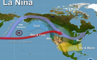
La Nina is a climatic pattern that refers to the cooling of the ocean surfaces along the tropical west coast of South America. During this weather pattern, warm ocean water and clouds move westwards increasing the chances of places like Indonesia and Australia getting much more rain than usual. These fluctuations tend to leave the regions of southwestern U.S. extremely dry.
The most severe La Nina occurrence in recent history was the 1988-89 event, which led to a seven-year drought in California. La Niña is a complex weather pattern that occurs every few years, as a result of variations in ocean temperatures in the equatorial band of the Pacific Ocean, The phenomenon occurs as strong winds blow warm water at the ocean’s surface away from South America, across the Pacific Ocean towards Indonesia. As this warm water moves west, cold water from the deep sea rises to the surface near South America; it is considered to be the cold phase of the broader El Niño–Southern Oscillation (ENSO) weather phenomenon, as well as the opposite of El Niño weather pattern. The movement of so much heat across a quarter of the planet, and particularly in the form of temperature at the ocean surface, can have a significant effect on weather across the entire planet.
Tropical instability waves visible on sea surface temperature maps, showing a tongue of colder water, are often present during neutral or La Niña conditions.
La Niña events have occurred for hundreds of years, and occurred on a regular basis during the early parts of both the 17th and 19th centuries. Since the start of the 20th century, La Niña events have occurred during the following years:
1903–04
1906–07
1909–11
1916–18
1924–25
1928–30
1938–39
1942–43
1949–51
1954–57
1964–65
1970–72
1973–76
1983–85
1988–89
1995–96
1998–2001
2005–06
2007–08
2008–09
2010–12
2016
2017–18
2020–22
Credit : Wikipedia
Picture redit : Google


