?APS
Maps provide visual representations of the world, revealing the layout of our planet in a variety of ways. Some depict Earth’s geographical features, or the borders and boundaries between nations. Other maps detail road routes and street names, or aid navigation on urban transport networks. Scales on maps can be used to work out real distances, and keys explain map symbols.
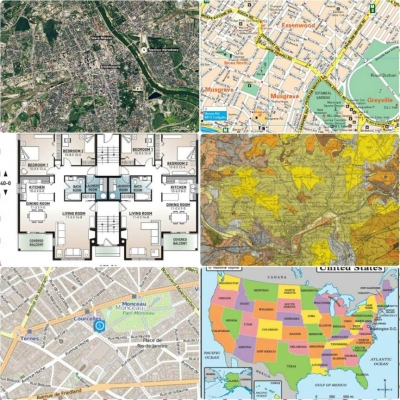
- SATELLITE IMAGE
Space satellites are used to photograph Earth, capturing its surface in great detail. Orbiting thousands of kilometres above the planet, satellites track changes in the land, the ocean, and the atmosphere.
- BUILDING PLAN
When planning a new structure, engineers first map out the building. Details such as layout, walls, and entrances are marked to assist workers during the construction. Precise measurements are added to give the true size of the project.
- STREET MAP
Useful tools for navigating cities and towns, street maps include road names and notable landmarks such as railway stations, hospitals, churches, and parks. Street maps are available online and via some mobile phones.
- GEOLOGICAL MAP
Different rock types are coded by colour on geological maps. Geologists study these maps to determine the location of minerals and oils, while structural engineers ensure rock types suit their construction plans before laying foundations.
- ROAD MAP
This visual aid for road-users is the most commonly used map of all. Covering a much larger area than a street map, road maps use different colours and lines to represent motorways, main roads, and country routes.
- SAILING CHART
Nautical maps of coastal or ocean areas are called charts. They include information about tides, currents, depths, potential hazards, and features of the seabed. Sailors carry these charts on board their ships to help with marine navigation.
- POLITICAL MAP
National and state borders are shown on political maps. Contrasting colours highlight different countries, so the legal boundaries stand out more clearly. To aid understanding, major cities, rivers, seas, and oceans are also labelled.
- PHYSICAL MAP
Permanent natural features are depicted on physical maps. Deserts, mountains, lakes, rivers, and oceans are identified, as well as the contrast between high and low land. Some physical maps go into more detail, pointing out land use and soil type.
Picture Credit : Google


