What is cloud seeding?

The United Arab Emirates (UAE) has a desert climate, characterised by mild winters and very hot summers. The humidity of the Persian Gulf makes the heat unbearable. It records an average rainfall of 100 mm every year. However, in recent years, the intensity of rainfall has gradually increased in the country. This is credited to the cloud seeding operations undertaken by its meteorological department. It is not just the UAE, even India. China and many other countries use this weather modification procedure to cause rain or to increase its intensity to address drought and water shortage. It is also used to control air pollution and to cause snow.

Cloud seeding is an attempt at inducing moisture in the clouds to generate rain. It involves use of chemicals that target rain-bearing clouds above a catchment area such as a river, reservoir or a lake. The chemical agents are dispersed in clouds using either aircraft or by ground-based dispersion devices that use rockets or guns to fire canisters of chemicals Sodium chloride (common salt), silver iodide, potassium iodide and dry ice (solid carbon dioxide) are some of the chemicals used. The cloud seeding missions are not constrained by seasons and are carried out throughout the year when seedable clouds are detected.

How does it work?

You may be aware of the evaporation process, which is an essential part of the water cycle. The sun drives evaporation of water from oceans, lakes and even moisture from the soil. The water molecules escape and form water vapour. The vapour remains in the atmosphere until it condenses to form raindrops, ice crystals and then into clouds. That is, clouds form when supercooled water vapour condenses and then freezes onto particles, called ice nuclei. Over time, the droplets and crystals that make up a cloud can attract more water to themselves. When water droplets grow heavy enough, gravity pulls them down as raindrops.

In the seeding process

As mentioned earlier, in the cloud seeding process chemicals that can aid precipitation are seeded (dispersed) into rain-bearing clouds. When these particles meet moisture in the clouds, they act as artificial ice nuclei and trigger the formation of more ice crystals and raindrops. The deficit in moisture content could be made up by using hygroscopic (water absorbing) material such as common salt.

Picture Credit : Google
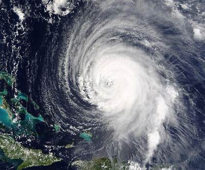
When does a storm become a hurricane?


Some people might answer: when it blows the roof off your house. The weather men see it differently. ‘Hurricane’ is one of the names given to violent tropical storms. These develop over warm tropical seas and blow up into huge spinning storms of clouds and rain. Hurricanes can be driven by winds reaching speeds of 300 kilometres per hour and can cause terrible damage.


The system used to measure wind speed is called the Beaufort scale. Hurricane is at the top of the scale and is known as force 12. When the wind reaches 122 kilometres an hour, a violent storm of force 11 becomes a hurricane of force 12.


Picture Credit : Google


Who predict the weather?


Weather Watchers


Everyone is a weather watcher, but almost no one knows how hot, how cold, or how wet it will be tomorrow or next week. But meteorologists can predict the weather.


A meteorologist is a scientist who studies the earth’s atmosphere and its weather and climate. Meteorologists are weather watchers or weather forecasters.


How do meteorologists predict the weather? They search for clues. They check the wind’s speed and direction. They record the temperature of the air, the air pressure, and the amount of water in the air.


Meteorologists also gather information from weather satellites in outer space. These satellites circle the earth and photograph clouds and any gathering storms. The pictures are then sent back to the earth.


Information also comes from weather stations on the earth’s surface. A type of radar called Doppler is used to study winds and storms. It can find approaching storms more than 320 kilometres away from the station.


Meteorologists gather weather reports from all over the world. They use this information to draw weather maps. They also use computers to make forecasts. You hear their forecasts every day on television or over the radio. But since the weather changes quickly sometimes, meteorologists usually update their forecasts.


Picture Credit : Google


What is Weather?


Weather


Somewhere on the earth right now, it is cloudy and rainy. Somewhere it is sunny. Somewhere it is dark, windy, and snowing.


What is the weather like today where you are? Is it raining? Does it look as if it’s about to snow? Is the sun shining?


Do you ever talk about the weather? Many people do. Almost everyone cares about the weather.


The weather affects us in many ways. Day-to-day changes in weather can influence how we feel and the way we look at the world. Severe weather, such as tornadoes, hurricanes, and blizzards, can disrupt many people’s lives because of the destruction they cause.


Weather doesn’t just stay in one place. It moves, and changes from hour to hour or day to day. Over many years, certain conditions become familiar weather in an area. The average weather in a specific region, as well as its variations and extremes over many years, is called climate.


There are six main components, or parts, of weather. They are temperature, atmospheric pressure, wind, humidity, precipitation, and cloudiness. Together, these components describe the weather at any given time. These changing components, along with the knowledge of atmospheric processes, help meteorologists - scientists who study weather - forecast what the weather will be in the near future.


Picture Credit : Google


HOW DO METEOROLOGISTS FORECAST THE WEATHER?


          As everyone knows, predicting the weather can often be difficult. Professional weather forecasters, called meteorologists, use information collected by weather stations on land, at sea and on satellites in space. Rainfall, sunshine and wind speed can all be measured fairly easily, but they only tell us what the weather is like now. A better gauge of future weather is to study air pressure and cloud formation. Today's meteorologists use computers to help make sense of all the information received and to predict, based on past events, the weather of the future.


          ‘Observations’ are the readings of the weather that we take—not only quantities like air pressure, temperature and rainfall at the surface, but measurements in the upper atmosphere from weather balloons and aircraft, and also data from weather radars and satellites. Together, these observations of many different elements that make up the weather paint a picture of how it has been recently, and how it is right now. This information is critical—to forecast the weather into the future, we need to know where to start from!


          Computer Weather models, or technically, ‘numerical weather prediction’ models, are the main tools we use to forecast the weather. In a nutshell, they take all of the mathematical equations that explain the physics of the atmosphere and calculate them at billions of points within the atmosphere around the Earth. The weather models require enormous computing power to complete their calculations in a reasonable amount of time, meaning they use some of the most powerful supercomputers in the world—our supercomputer, for example, can handle more than 1600 trillion calculations per second! The models take the past and current weather observations of the atmosphere and ocean as the starting point, and plug them into the mathematical equations that calculate the weather into the future.


          Meteorologists are able to predict the changes in weather patterns by using several different tools. They use these tools to measure atmospheric conditions that occurred in the past and present, and they apply this information to create educated guesses about the future weather. Always remember that a weather forecast is an educated guess – meteorologists (and mankind, in general) cannot control the weather. The best we can do is observe past and present atmospheric patterns and data, and apply this information to what we think will happen in the future. Meteorologists use the scientific method on a daily – and even hourly – basis!


Picture Credit : Google


ARE WEATHER AND CLIMATE THE SAME THING?


          The lower levels of the Earth’s atmosphere are in constant motion. As the atmosphere heats and cools, it expands and contracts, causing changes in pressure and air movement. These changes cause the weather that we experience on Earth. The daily occurrence of sunshine, rain, hail, snow, fog or wind is what we call weather.


          Climate is the overall weather in a particular area over a longer period of time. Weather, as in a weather forecast, refers to short-term conditions in the atmosphere in a particular location or region.


          Climate, on the other hand, describes the average daily weather for extended periods, such as if winters are cold and snowy or if summers are hot and humid, according to the National Oceanic and Atmospheric Administration. Basically, climate is the average weather pattern in an area over a longer period of time, and weather patterns, according to NOAA, are caused by the flow in atmosphere. 


          “Weather is the mix of events that happen each day in our atmosphere,” NOAA reported. Although there is just one atmosphere on Earth, the weather is different around the world and changes over minutes, hours, days and weeks. A given area may experience a warm winter, or maybe a wet month or even a rainy decade, but that variance are still weather-related.


          So, one of the main differences between weather and climate is time, with weather referring to a short span of time and climate referring to longer-range weather patterns in a region, generally over 30 years or more. “While weather can change dramatically in a single location from day to day (for example, cold and rainy one day, followed by hot, dry conditions the next day), climate generally changes less quickly because it represents the average of weather conditions over a longer period of time,” according to the American Geosciences Institute.


          There are generally five types of climate, including dry, temperate, tropical, continental and polar. It’s hotter near the equator, for example, so locations closest to the equator have a more tropical climate, while areas closest to the Arctic and Antarctic have a polar climate. When it comes to weather, National Geographic reports, there are six main components: temperature, wind, humidity, atmospheric pressure, precipitation and cloud cover. Weather can includes all kinds of conditions, such as sunshine, rain, hail, snow, flooding, blizzards, thunderstorms, heat waves and more.


Picture Credit : Google


How can scientists control the weather?


            Since the 1940s scientists have discovered techniques by which. Several weather conditions can be controlled. For example, it is pos­sible' to prevent lightning by using an electrical earth to diffuse the electrical content of a cloud. The American scientist V. J. Schaefer has shown .that it is feasible to produce greater concentrations of ice in clouds than occur under normal conditions.


            Weather experts already are taking advantage of these dis­coveries to increase snowfall on mountains for winter sports, to prevent damaging hailstones and to moderate, or even prevent, the development of dangerous storms. Scientists are now able, in some cases, to make a cloud burst to produce rainfall over parched areas.


            These local efforts may lead the way to large-scale weather con­trol. But before then scientists may' have to learn to cope with the damaging effect of air pollu­tion on weather conditions.


Picture credit: google


Climate Extremes


Can sand dunes move?


Sand dunes can move slowly, causing deserts to spread over more fertile land. Continuous winds blow the sand to form crescent-shaped dunes. Sand from the top of the dune is blown farther away, and it gradually collects to form a new dune.


Picture credit: google


How can people live in extreme climates?


Over millions of years, the human body has altered to suit the climate of the regions we inhabit. In general the hotter the region, the darker the skin of its inhabitants. Also, many people from Asia have a fold of skin in their eyelid to protect them from strong sunlight. People living in hot climates do not need a fat layer to keep warm, so they are usually slim. The Inuits of the Arctic, however, are mostly shorter and stockier to help conserve heat. 


Picture credit: google


Which are the wettest places on the Earth?


Tropical rainforests are among the wettest places in the world. In general, most rainfall occurs on the sides of hills and mountains. The wettest place of all is Cherrapunji, in Assam, India. It faces the full force of the monsoon winds that sweep in from the Indian Ocean in July. Their warm, damp air rises in the Himalayan foothills, causing torrential rain. Mount Wai-‘ale-‘ale in Hawaii has the wet days each year. It rains on 350 days on average, and the annual rainfall is the highest recorded anywhere.


Picture credit: google


Climate Extremes


What is permafrost?


Permafrost is a layer of ice and frozen soil that never thaws. It lies beneath nearly one-quarter of the Earth’s surface, throughout Alaska, Canada and Russia. Sometimes the soil in these places is frozen to a depth of up to 1,500 m. The surface layers may melt enough in summer for plants to grow, but the soil beneath is permanently frozen.


Picture credit: google


Are there places where nothing can live?


Hot volcanic lava is probably the only place on the Earth’s surface where there is no life at all. Living things have evolved to survive in the harshest environments. Tiny bacteria can be found everywhere on the Earth, even buried in thick ice at the poles or in the very deepest parts of the ocean. 


Picture credit: google


Climate Extremes


Where are the most extreme temperatures found?


Libya and the Antarctic have recorded the most extreme temperatures. The hottest shade temperature was in Libya in 1922, when the temperature in the Sahara desert reached 58 °C. Temperatures nearly as high as this were recorded in Death Valley in the USA in 1913. The coldest ever recorded temperature was in Antarctica in 1983, when Russian scientists measured a temperature low of - 89.2°C.


Picture credit: google


The desert process


Deserts were once green and fertile areas, until a climate change altered them permanently. Just a small reduction in rainfall causes plants to die off. Without plant roots to bind and nourish the soil, the land gradually becomes barren. Soon the animals move away, and only desert remains. Very few deserts are completely barren, and plants and animals have evolved to live in the driest conditions, conserving their body water so they do not need to rely on rainfall.


Picture credit: google


Climate Extremes


Are there cold deserts?


Antarctica is the biggest cold desert in the world. All of its water is locked up in ice and snow, so nothing can grow. The Gobi desert in Mongolia and western China is also very cold in the winter, when temperatures drop below freezing. However, it is hot in the summer.


Picture credit: google


What is a mirage?


Mirages form in hot deserts, where the air is so hot it bends and distorts light rays. The shimmering images that a mirage produces have often tricked travellers in deserts. People think that they can see a town or oasis on the horizon, but in reality there is none. 


Picture credit: google


Climate Extremes


Where is the world’s driest place?


The world’s driest place is the Atacama Desert in Chile. It is a narrow strip between the Andes and the Pacific, where the first rain for 400 years fell in 1971. Like other hot deserts, the Atacama lies in a region where air pressure is constantly high, with little air movement or cloud. Rainfall is very low in other deserts. Near Cairo, Egypt, annual rainfall averages about 28 mm each year, while in Bahrain, on the edge of the Arabian Desert, there is as much as 81 mm of rainfall. The rain may come in a single heavy storm, and some years there is no rainfall at all. 


Picture credit: google


How much of the world is covered by desert?


About one-third of the world’s land surface is covered by desert. Desserts are found wherever there is too little water to allow much plant life to grow. This lack of vegetation leaves large areas of soil exposed. The largest desert in the world is the Sahara in Africa. It has an area of about 9 million sq km. 


Picture credit: google


Weather


What are ‘highs’ and ‘lows’?


Air pressure varies across different parts of the Earth’s surface, and this difference causes winds. Air moves from an area of high pressure, or an anticyclone, to an area of low pressure, or a depression. Depressions are usually associated with worsening weather conditions and rain. These changes in air pressure can be measured by an instrument called a barometer. In a mercury barometer the air pressure pushes down on the mercury, which is forced up the barometer to give an accurate reading. 


Picture credit: google


Why do we get thunder and lightning?


Lightning is a huge spark of electricity that is produced in a cloud. Thunder is the loud noise made by the lightning as it rips through the air.


During thunderstorms, enormous electrical charges build up inside a cloud. Eventually the charges seem to flow down to the ground when lightning strikes. In fact, the electrical charges flow up from the ground and down from the cloud at the same time. The tremendous heat generated by the lightning causes the explosive noise of thunder. Lightning frequently strikes in the same place repeatedly, and along the same path through the air. It can also strike between two clouds.


Picture credit: google


Weather


Thunderbolts


A lightning strike discharges about 100 million volts of electricity, and heats the air in its path to more than 33,000°C.The lightning strike travels at 299,792 km per second, which is almost the speed of light. A strike between a cloud and the ground may be 14 km long, and a strike between clouds can be over 140 km long.


Ball lightning is a small fiery ball which occasionally appears during thunderstorms. There is no accepted scientific explanation for it. 


Picture credit: google


How can forecasters predict the weather?


Meteorologists use a wide range of instruments and techniques to help them track changes in the weather and to predict future weather conditions. Weather forecasters have used simple instruments such as thermometers, rain gauges, barometers and wind gauges for many years, but the advent of satellite photography has transformed weather forecasting. Weather satellites can track the movements of clouds, and show the positions of high and low pressure areas and weather fronts. Radar measures the size, speed and direction of storms, so accurate warnings of severe weather can be given. With the use of computers, increasingly accurate forecasting is now possible.


Picture credit: google


Weather


What causes mist and fog?


Tiny water droplets condensing from moist air cause both mist and fog. They can occur at ground level. The air can only hold a limited amount of water vapour. If the air suddenly cools, its capacity to hold water is reduced, resulting in mist or fog. When fog occurs visibility can be affected. Mist is less dense. It commonly occurs on calm, clear nights when heat rises, forming a thin layer of mist close to the ground. 


Picture credit: google


How are hailstones formed?


Hail is produced when particles of ice bounce up and down inside a cloud. In cold temperatures, water droplets inside a cloud will freeze into small pellets of ice. As these begin to fall, they may meet warm air rising, which carries them back up into the cloud. There they cool once more, and the process is repeated. As more and more water freezes onto their surface, the ice pellets gradually grow in size. Eventually they become so heavy that they fall to the ground as hailstones. Some hailstones are as big as a clenched fist and can do serious damage to buildings and livestock. 


Picture credit: google