Why is the Giant’s Causeway an amazing site to see?

               The Giant’s Causeway is an extensive area covering about 40,000 interlocking basalt columns. It is spread over six kilometres along the northern coast of Northern Ireland, on the edge of the Antrim plateau. These stone pillars with up to seven irregular sides that point out of the cliff are just a spectacular sight.

               This Causeway was formed some 50 million years ago as a result of a volcanic eruption that caused lava to flow towards the coast. When it came in contact with the sea, the lava cooled, forming layers of basalt columns. And because of the pressure between the columns, each of them sculpted into different shapes. Ever since it was first documented. in 1693, the Giant’s Causeway has been subjected to studies by geologists. It stands as a special place, not just for the formations but also for the grasslands close by. There were human settlements in the area during the 1800s, but it is now uninhabited. However, more than three lakh persons visit the site every year. 


What makes Andalusia a thrilling place to visit?

          Andalusia is a historical region of Spain, located in the southern portion of the country. It is an autonomous community which has the city of Sevilla as its capital.

          Divided into eight provinces, Andalusia is the most populated and the second largest of the communities.


          Andalusia was a wealthy and politically influential region. Even today the remains of its culture and traditions can be seen in the community’s architecture, language and customs. The famous bull fights and the gypsy flamenco music with dance are two highlights of the culture.


          Other major tourist attractions here include the city centres of Ubeda and Baeza in the province of Jaen, both which are UNESCO World Heritage Sites, the Great Mosque of Cordoba, the Alhambra in Granada, along with numerous museums, cathedrals, castles, forts, monasteries and stunning beaches. 


Why are the Dolomites an amazing place to see?

            The Dolomites are a fascinating group of mountains that lie on the eastern section of the northern Italian Alps. It consists of a number of majestic peaks out of which 18 rise to more than 1000 feet. The Marmolada is the highest of all, at a height of 3341.8 metres.

            The first scientific study about the region was made by the 18th century French geologist Dieudonne Dolomieu. It is from him that the mountain range and its rock took their name. Geologically, the range is formed of light-coloured dolomitic limestones. As many as 41 glaciers are seen in the region. Most of the lower slopes of the mountain were once covered by thick forests, but today only patches of woodland remain.


            The main peaks of the Dolomites were climbed in the 1860s by English mountaineers. However, the range has witnessed major disasters after that. In 1963, more than 2500 people died after a landslide occurred in the southern Dolomites. It caused the Vaiont Dam to overspill and flood the village of Longarone.


Why is Mont Blanc famous?

            Mont Blanc or Monte Bianco is the highest mountain in Europe. It is located in the Alps and lies along the border of France and Italy, extending to Switzerland. Ranked 11th in the world in topographic prominence, the mountain rises to a height of 4,808 metres above the sea level.

            Literally meaning ‘White Mountain’, the Mont Blanc is covered for at least 100 square kilometres by glaciers.


            The importance of the mountain was brought before the world in the 18th century when P. Martel, Jean A. Deluc and Horace Benedict de Saussure drew attention to it as the Western Europe’s highest mountain, in separate attempts. It later created an interest among climbers.


            In 1786, the summit was conquered by Michel-Gabriel Paccard and Jacques Balmat Today, the region is one of the most important tourist centres on the continent, and has facilities for winter sports as well. The famous Mont Blanc Tunnel is another major attraction here. 


Why is Petra tou Romiou a famous tourist location?


            Petra tou Romiou or the Rock of the Greek is a sea stack seen in the coastal city Pafos in Cyprus.


            What make the formation famous are its beauty as well as mythological relevance. The rock has a magnificent structure with corals, seaweed and pieces of shells on it.


            According to legend, Petra tou Romiou is situated where the Greek goddess Aphrodite was born. Hence, it is also known as Aphrodite’s Rock. According to another folk story, a person who swims around the rock is believed to be blessed with eternal beauty. However, this may not be easy, as the sea is usually very rough making it difficult to enter the water. Tourists are often advised not to swim here. Climbing the rock is also prohibited.


            There is one more legend associated with the Petra tou Romiou. It says that the rock was thrown by Basil, the legendary hero in the epic of Digenes Akrites, from the Toodos Mountains. He did this to destroy the Arab ships that were on the way to take over Cyprus. The rock landed where it is now situated.


What makes Black Forest an amazing place to see?

           The Black Forest is a thickly wooded mountain region in the state of Baden-Wurttemberg, in southwestern Germany.


          The name of this region comes from the dark-coloured fig and pine trees present in the region. Other than this lushness there are many features in the area that attract thousands of people to this location every year. The Titisee and the Schluchsee lakes are two of them. They offer opportunities for water sports like diving and wind surfing for adventure lovers. Then there is the spa-town of Baden-Baden that is noted for the numerous thermal baths, the imperial town of Gengenbach and the flower and wine village of Sasbachwalden.


          For travellers in search of picturesque, old towns, places like Altensteig, Dornstetten, Freiburg im Breisgau, and Gernsbach would be the ultimate options. There are as well the former monasteries of St. Blasien, the abbeys of Saint Trudpert that fascinate people from all over the world. 


What makes Tuscany a place to see?

          Tuscany is a region in west-central Italy that is marked for its landscapes, traditions, art and history. The city of Florence is its capital. Geographically, the region comprises the provinces of Massa-Carrara, Lucca, Pistoia, Prato, Firenze, Livorno, Pisa, Arezzo, Siena, and Grosseto.

          There are multiple reasons why tourists across the world prefer Tuscany for a vacation. As a matter of fact, it is one of the most visited places in the world. For people in love with culture, the region has much to offer. The churches, palaces, art galleries, museums and villages of Tuscany reflect its unique cultural and artistic heritage. There are also many art schools which have created famous artists, and contributed to the region’s nickname as the ‘art palace of Italy’. Hence the place is rightly regarded as the birthplace of Italian Renaissance which was a major cultural movement in world history.


Why is Oaxaca popular?

            Oaxaca or the Free and Sovereign State of Oaxaca are a state in southern Mexico. Specifically, it is one of the states that constitute the 32 federative entities of Mexico. What make the state so famous are its land, culture, and people.

             A large part of the state is mountainous, covered by the mountains of the Sierra Madre del Sur range. As it goes down south, the mountains turn narrower, and form a plain along the Pacific coast. In the east, it descends to the Isthmus of Tehuantepec.


            Historically, there were different native groups inhabiting the region that is now called Oaxaca.


           In the early 16th century, Spanish rulers conquered the region and controlled it for a long 300 years. Later, Mexico gained independence from the Spanish, and Oaxaca became a free state in 1824.


            It is now one of the most ethnically diverse states in the country with a number of indigenous groups. The capital of the state, Oaxaca de Juarez is the site of the major cultural institutions here, including the Benito Juarez University of Oaxaca and the Regional Museum of Oaxaca.


Why is Tikal a popular tourist destination?

            Tikal was a major city and ceremonial site of the Ancient Mayan civilization. It was also an urban centre in the southern Maya lowlands which stood 30 kilometres north of Lake Peten ltza. Today, this place is in the archaeological region of Peten in northern Guatemala.

            Historically, Tikal was first developed as a small village during 900-300 BC. With the construction of pyramids and temples, it later became a ceremonial centre. It was also an important point in the trading network that had been established in Southern Mexico and Central America by the central Mexican city of Teotihuacan.


            However, the city reached its greatness during AD 600 when palaces, pyramids and plazas were built. This was also the time when Mayan art flourished in sculpture, monumental and vase painting. The city reached its architectural and artistic peak between AD 600 and 800, after which it saw a steep decline. Population fell and so did its art. By the 10th century, Tikal was abandoned.


            The Tikal Project of the University of Pennsylvania recorded over 200 monuments at the site.


Why is Vieques said to be an amazing place to visit?


Vieques or the Isla de Vieques is a beautiful island of Puerto Rico in the northeastern Caribbean. It is part of the Spanish Virgin Islands and retains influences from centuries-long Spanish presence in the land.


Geographically, Vieques is about 34 kilometres long and 6 kilometers wide. Isabel Segunda, the chief town and Esperanza, a fishing village are two of the important places on the isle.


There are many reasons why Vieques is known to the world. The closeness to waters as well as the hilly terrain is indeed fascinating. But what brought this little island to global attention was a series of protests.


History says that in the early 1940s, a large part of the island was occupied by the US Navy. But, the protests from the natives forced the US Navy to withdraw from the island. Following this, Vieques was designated a National Wildlife Refuge. Today, it is a major hub of ecotourism with unspoiled beaches along with historical remains attracting thousands of visitors each year. 


What makes Denali special?

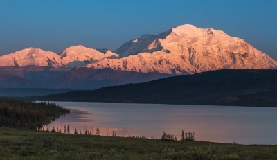
          Denali is the highest mountain peak in North America that is located close to the centre of the Alaska Range in South-Central Alaska.

          After Mount Everest and Aconcagua, Denali is the third most prominent and isolated peak on Earth. It is a giant block of granite believed to have been lifted above the earth’s crust due to tectonic activity, millions of years ago.


          There are two significant summits on the peak, the South Summit which is the higher one, and the North Summit. Flowing off the slopes of the mountain are five large glaciers.


          Starting from 1903, many attempts were made to climb the summit of Denali. However, the first successful ascent was recorded on June 7, 1913, by climbers Hudson Stuck, Harry Karstens, Walter Harper, and Robert Tatum. Today, Denali is a famous spot among climbers.


          The term ‘Denali’ was the name given to the mountain by native Athabascan Indians. It means ‘The Great One’. 


Why is Katmai National Park and Preserve famous?

          The Katmai National Park and Preserve is an area in southwestern Alaska, US, most noted for its wilderness and distinctive geologic features.

          Named after Mount Katmai, the park has 18 individual volcanoes out of which seven are active. In fact, the area was made a national monument in 1918, six years after the violent eruption of the Novarupta Volcano.


          One of the important landmarks of the Katmai National Park is the Valley of Ten Thousand Smokes. It was a green valley that got converted into an ash-filled wasteland after the eruption of the Novarupta.


          The park is also noted for its lakes, forests, rivers, marshlands and wildlife. The Snowshoe hare, Alaskan moose, Canadian lynx, wolverine, river otter, mink, red fox, weasel, marten etc., are some of the mammals in the area. There are also marine mammals like the harbour seal, sea lion and sea otter. However, the most prominent animal here is the Alaskan brown bear. Katmai has the world’s largest protected brown bear population. 


What makes the Dry Tortugas National Park an interesting tourist location?

          The Dry Tortugas National Park is a name that remains synonymous with marine beauty. Located on the Dry Tortugas islands in southwestern Florida, the park covers an area of 262 square kilometers. It was built to preserve Fort Jefferson and the seven Dry Tortugas islands that lie west of Key West in the Gulf of Mexico.


          As mentioned before, the Dry Tortugas National Park is noted for its rich sea life. The colourful coral reefs, legends of shipwrecks, and tropical bird breeding grounds are some of the best spectacles here. Fort Jefferson is another reason why the park is important. It is a massive, unfinished coastal fortress, which happens to be the largest masonry structure in the Western Hemisphere.


          The fort was built with more than 16 million bricks. Besides its historical significance, the park is also a renowned site for bird watching. The parade ground of the Fort is the place where one can spot numerous birds.


Why is the Oneonta Gorge so famous?

              The Oneonta Gorge is a gorge located in the Columbia River Gorge area of the Oregon state. A gorge, as some of you might know, is a narrow valley with steep walls lying between hills or mountains.

               The Oneonta Gorge is a highly impressive formation that is often described as ‘one of the true dramatic chasms in the State’. The gorge is special for the unique aquatic and woodland plants growing in the region. The walls of the basalt rocks here are home to a wide variety of ferns, mosses, hepatics or liverworts and lichens which are found exclusively within the Columbia River gorge.


               There are four major waterfalls on the Oneonta creeks that run through the gorge. The Middle falls can be seen clearly from a footpath at a distance, but the lower falls can be seen only by walking upstream from the creek’s outlet at the Historic Columbia River Highway.


               Similarly, the Upper Falls can be viewed if one can climb up the creek or climb down a canyon wall.


               The fourth falls or the Triple Falls can be seen from a point on the upper trails of the canyon.


Why is Big Sur an amazing place to see?

            The Big Sur is a scenic region in Western California, US that comprises a 160 kilometre long stretch of sea coast along the Pacific Ocean.

            It is regarded as the greatest meeting of land and water in the world, where the Santa Lucia Mountains rise sharply from the ocean.


            The coastal roads that are winding and narrow provide enchanting views of the Pacific Ocean and the wild areas of the Los Padres National Forest nearby. Another important place here is the Pfeiffer Big Sur State Park, spread over more than 323.7 hectares. It is home to a wide variety of wildlife and trees like coastal red-woods.


            The park contains the village of Big Sur. The Garrapata, Andrew Molera, and San Simeon, and Point Sur State Historic Park are some of the other state parks in the Big Sur area.


            This place which is now a major tourist destination was once just cattle ranches and small farms. Many writers have appreciated the beauty of Big Sur in their works. American poet Robinson Jeffers is one of them. His home is now one of the landmarks of Big Sur.