Which is the second largest continent?


Africa is the second largest continent. Steamy tropical rain forests cover parts of western and central Africa. The Sahara, the world’s largest desert, stretches across most of the northern part. The longest freshwater lake in the world, Lake Tanganyika, lies in eastern Africa.


A sea separates most of Africa and Asia, but in one place the two continents meet.


Africa has 54 countries. Its largest country is Algeria. The smallest is Seychelles. Most Africans live in rural areas, but some live in cities such as Addis Ababa in Ethiopia, Cape Town in South Africa, and Lagos in Nigeria.


Many people travel to Africa to study its wild animals, visit such ancient sites as the pyramids of Egypt, or see such natural wonders as Victoria Falls and Kilimanjaro, a towering volcano that is no longer active.


Picture Credit : Google


Which is the biggest continent in the world?


Asia is the largest continent by far. It has more land and more people than any other continent. It is so big that Australia and North America could fit inside it. Asia and Europe are joined along one side.


Asia has some of the world’s highest mountains, largest deserts and plains, and thickest jungles. There are cold deserts in central and northern Asia, hot deserts in the southwest, and steamy tropics in the southeast. Many Asians live in crowded cities, such as Tokyo in Japan. Delhi in India, and Beijing in China. But there are also many places in Asia where very few people live.


There are 50 countries in Asia. Two of the world’s largest countries, Russia and China, are in Asia. In fact, Russia is so big that it lies on two continents. Part of it is in Europe and part of it is in Asia.


Visitors to Asia often visit the Great Wall of China. It was built more than 1,000 years ago and stretches thousands of kilometres across north-central China. Many mountain climbers are drawn to Asia’s Mount Everest, the highest peak in the world.


Picture Credit : Google


Which are the continents of the world?


The earth has seven huge land areas called continents. Some are connected to each other. Others are completely surrounded by water. These chunks of land are so large that some may have snowy mountains on one part and steamy forests on another. They may have dozens of countries or just one. What are the names of these seven continents, and how is each one special? Which one is the largest? Which one has the most people?


The seven continents are Africa, Antarctica, Asia, Australia, Europe, North America, and South America. Australia is an island, a piece of land totally surrounded by water. But it is such a huge island that it is also a continent. Other continents, such as Europe and North America, have islands that are part of them. There are also thousands of smaller islands, such as group of islands called the Pacific Islands, that are not counted as part of the continents. Europe and Asia are joined on one side, but they are thought of as two continents.


For example, on map if you look closely, you will see that each continent has a different shape, use tracing paper to trace the shape of each continent.


Picture Credit : Google


WORLD ATLAS - NORTHERN AFRICA


The northern half of Africa stretches down from the fertile coast bordering the Mediterranean Sea, through vast areas of desert and savanna, into the forests of the west and central Africa. Apart from the Atlas Mountains, the Ethiopian Highlands and Saharan ranges, much of the region is a level plateau.


In the far north of Africa, the countries bordering the coast benefit from natural resources of oil and gas. They also rely on tourism and the manufacture of textiles and carpets. The population is mostly Arabs. Berbers, an ancient native people, live in the uplands of Morocco.


South of the Sahara, agriculture is the primary industry of many countries. Rivers such as the Nile, Niger and Senegal provide essential water with which to irrigate crops. However, in many countries such as Mauritania and Mali, drought is a recurrent problem. In the driest areas, nomadic cattle-herders travel vast distances in search of good grazing.


There are many different peoples living in Northern Africa. Conflict between them often leads to long and devastating wars. The combination of war, drought and widespread poverty has led to terrible famines in Ethiopia and Sudan.


West Africa has a wetter climate, and crops such as coffee, bananas, cocoa, groundnuts and citrus fruits are grown. For many years, timber has been an important product of countries such as the Cote d’Ivoire, but this was carried out at such a rate that vast areas of the forest have now disappeared. Mining of oil and metal ores is a rich resource, but due to poor government and frequent wars, many countries are still impoverished.


Many people in Northern Africa live in small towns or villages, producing just enough food and goods for themselves. Others crowd into the cities, looking for work. They often have to live in very poor conditions on the outskirts of the city.


Picture Credit : Google


WORLD ATLAS - SOUTHERN AFRICA


The Congo basin covers much of central Africa. Here, the mighty Congo River winds through dense rainforest, where animals such as the rare mountain gorilla and a host of bird species live.


 To the south and east are high plateaux, with a cooler, drier climate. Much of the land is flat grassland, called savanna, where animals such as giraffes, elephants and lions roam. In the southwest, the savanna gives way to areas of hot, dry desert. In the east, deep valleys, high volcanic mountains and huge lakes have formed along a split in the Earth’s crust, known as the Great Rift Valley.


Southern Africa is rich in natural resources such as oil, metals (particularly copper and gold) and diamonds. Mining is therefore a vitally important industry. Tourism is also important to the savanna regions, where large national parks have been set up to protect the wildlife. In the eastern highlands, crops of tea and coffee are grown for export. Cattle are farmed for their meat and dairy products.


Outside South Africa and the Copper Belt (southern Congo and northern Zambia), large industrial areas are scarce. Countries such as Angola and Mozambique, with fertile land and rich resources, are nevertheless poverty-stricken due to years of civil war. Many people are farmers, and produce only enough food for themselves.


There are many hundreds of different tribal groups in Southern Africa, with many different languages and customs. Violent clashes between rival groups are frequent. In the worst affected regions, millions of people have fled to neighbouring countries to escape the conflicts.


Picture Credit : Google


WORLD ATLAS - AFRICA


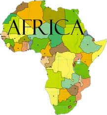
The second largest continent after Asia, Africa is almost completely surrounded by water, apart from the narrow point at which it joins on to Asia. The north of the continent is mostly hot, barren desert, edged with coastal areas that are cooler and wetter in winter.


Further south, the desert gives way to areas of flat grassland. The Equator runs right through the centre of Africa. The countries on or close to the Equator are dominated by the largest area of tropical rainforest outside South America. Here the climate is hot and wet.


The rainforest is home to many different plants and animals, including gorillas and chimpanzees. Many rivers weave their way through central Africa. To the east and south are large areas of open grassland scattered with trees, known as savanna. Animals such as elephants, zebra and wildebeest, roam the savanna, along with predators such as lions, wild dogs and hyenas.


AFRICAN PEOPLES


North of the Sahara desert, the people of Africa are mainly Arabs and Berbers, who follow the religion of Islam. South of the Sahara, most people are black. They follow a variety of religions. Much of Africa was at one time controlled by Europe, and today people of European descent still live there, mostly in the south.


Africa exports its natural resources of metals and oil, as well as crops such as coffee and cocoa. However, many African countries are poor compared to the rest of the world. Few have established manufacturing industries. Most people live in the countryside, and rely on producing only enough crops, or farming enough cattle to support their families. They suffer from frequent droughts, floods and periods of starvation. Wars between and within countries also threaten their lives.


SAHARA DESERT


The world’s largest desert, the Sahara stretches across an area of Northern Africa that is almost the size of the USA. It is constantly growing larger as the sparse grassland at its edges dies away. The Sahara is a hot desert, where rain may fail to fall for years on end. During the day, temperatures can reach over 50°C in the shade, but nights are often cold. There are areas of sand that often drift into large dunes, but much of the Sahara is made up of rocky ground and mountains.


Despite these harsh conditions, the Sahara desert is not without life. Animals that are specially adapted for life with little water and intense heat can survive there. Many take shelter in burrows during the day, coming out at night to feed.


People also live in the Sahara desert. Small towns are able to survive around oases in the desert. Groups of nomads also travel across the harsh landscape to trade in the town markets. For thousands of years, they carried their goods and supplies by camel, an animal that can cope extremely well with desert life. It also provided the nomads with milk and meat. Today motor vehicles are more often used to cross the desert.


Picture Credit : Google


WORLD ATLAS - AUSTRALIA


A part from a long range of mountains running down its eastern side, most of Australia is flat, hot and dry. It is rich in natural resources such as coal and minerals including gold, copper and iron. The vast interior, or outback, is mostly desert, or dry scrublands. To the east, this gives way to open grassland - stock-raising country, where Australia’s sheep and cattle ranches, or “stations”, are situated. With its millions of sheep, Australia is the world’s largest producer of wool.


Most Australians live around the coasts, where the climate is cooler and the land fertile. Crops such as wheat and tropical fruits are grown for export, and vineyards produce world-famous wines. A high proportion of people live in the largest cities, such as Sydney, Brisbane and Melbourne. The cities have modern manufacturing industries.


About 200 years ago, the British and other Europeans began to arrive on the shores of Australia. They routed many of the native Australians already living there, and seized their land. Today, much of Australia’s population is of European descent, although there are substantial numbers of immigrants from Asia. The small numbers of native Australians that remain are working to reclaim some of their land and sacred sites.


NEW ZEALAND


Like its neighbour, Australia, New Zealand is a prosperous country. It farms huge numbers of cattle and sheep, producing large quantities of wool, meat and dairy products for export. Its fertile land and warm climate also make it ideal for vineyards and fruit and vegetables. The power of New Zealand’s many rivers, and also the underground heat from volcanic activity on North Island, are harnessed through non-polluting electricity schemes.


The native peoples of New Zealand are the Maoris, who originally came from Polynesia. They still make up about nine per cent of the population, and have retained much of their culture and traditions.


Picture Credit : Google


WORLD ATLAS - JAPAN


Lying off the east coast of mainland Asia, Japan is made up of four large islands, where most of the population live, and thousands of smaller ones. The four main islands are Honshu, Hokkaido, Kyushu and Shikoku. Much of Japan is covered with mountains, some of them volcanic. It is also densely forested. Winter is cold in the north, but the south of the country has mild winters and hot summers.


With limited land available for farming, and a lack of natural resources, Japan has turned to industry and technology for its livelihood. Today, it is a leading producer of cars, ships and electronic goods such as computers, televisions and cameras. It is also a powerful financial centre. Most people live in the cities, several of which have a population of over one million. Their buildings are designed to withstand the earthquakes that frequently occur.


Picture Credit : Google


WORLD ATLAS - OCEANIA


Stretching across a vast region of the Pacific Ocean, Oceania is made up of the large island of Australia (almost a continent in itself) together with New Zealand, Papua New Guinea and thousands of small Pacific islands.


Much of Australia is covered with hot, dry desert and flat, open grassland known as the outback. Most people live in towns and cities near the coasts, especially the south coast. Papua New Guinea, in contrast, is a country of high mountains and dense rainforests. Many tribes of native peoples live in mountain valleys so isolated that they have only recently come into contact with the outside world.


New Zealand is made up of two islands, the north of which is warm and volcanic, while the south island is cooler, with mountains and forests. The grassy lowlands are fertile, and ideal for farming. The remote position of New Zealand, and also of Australia and Papua New Guinea, means that they are home to animals that are not found anywhere else in the world.


The Pacific islands are the remains of volcanoes that have erupted beneath the ocean. Some islands, such as Hawaii, still have active volcanoes. The islands are grouped together into nations. Some of these are independent, while others, such as New Caledonia, are colonies of European countries or the USA. Many Pacific islands are very beautiful, with rich vegetation and a warm climate. This makes them popular tourist destinations, and also, gives them plenty of fertile land for farming crops.


Picture Credit : Google


WORLD ATLAS - CHINA


The third largest country in the world, China also has the highest population - more than one-fifth of all the people in the world today. The west of the country is mountainous, with bleak deserts and grassland plains or steppes. The deserts are freezing cold in winter. The highest point is Mount Everest, which lies on the border between Tibet and Nepal. Tibet used to be an independent country, but has been occupied by China since the 1950s.


In contrast, the eastern part of China has a warm climate, with fertile soil and river valleys. Great rivers, including the Yangtse and the Huang He, or Yellow River, wind their way from the western mountains to the sea. The Grand Canal, the world’s longest waterway, stretches for 1790 kilometres. Most of the population of China lives in the east. China is a major producer of tea, wheat and sweet potatoes as well as rice, which is grown in the flat, flooded paddy fields of the south. Pigs and poultry are kept everywhere.


Many Chinese cities have populations of more than a million people. Most people live in apartment blocks. China has natural resources such as coal and oil, and also heavy industry such as steel and chemical plants. It is an important producer of textiles, clothing and electronics. Though many people in China are poor, it is a rapidly developing country.


MONGOLIA AND KOREA


Mongolia occupies the grassy plains between the mountains to the north and the Gobi desert to the south. Many people still live a nomadic life on the central plains. Mongolia has coal and oil resources.


North and South Korea are both mountainous and forested, but while North Korea has little contact with the outside world, and relies on enormous state-controlled farms, South Korea has thriving, modern industries and many trade links.


Picture Credit : Google


WORLD ATLAS - SOUTHEAST ASIA


The southeast corner of mainland Asia, together with thousands of islands further south, makes up the region of Southeast Asia. On the mainland are the mountainous, forested countries of Thailand, Laos, Vietnam and Cambodia. Great rivers flow through the region, creating fertile valleys where large quantities of crops such as rice and tropical fruits are grown. Thailand also has successful tourist and manufacturing industries. Cambodia, Vietnam and Laos have been devastated by war, although Vietnam now has a growing industrial economy.


Malaysia is made up of the mainland Malay Peninsula, and most of northern Borneo. Southern Borneo, together with other islands including Sumatra and Java, is part of Indonesia. The climate is hot and wet, with areas of dense rainforest that are home to many kinds of plants and animals. Malaysia and Indonesia are rich in natural resources such as oil, gas and rubber. They also have strong manufacturing industries.


North of Borneo are the Philippines, thousands of small islands, many of which are uninhabited. Although their country is rich in mineral resources, many people are obliged to leave to find work in other countries. Both the Philippines and Indonesia are frequently threatened by tropical storms, volcanoes and earthquakes.


The small countries of Singapore and Brunei are among the world’s rich countries. While Brunei has huge resources of oil and gas, Singapore is a worldwide centre of manufacturing and business.


Picture Credit : Google


WORLD ATLAS - SOUTHERN ASIA


The Indian subcontinent encompasses India, Pakistan, Bangladesh, Nepal, Bhutan and Sri Lanka. Much of the northern region is mountainous, with the Himalaya and Karakoram ranges forming a border with the rest of Asia. A region of desert covers eastern Pakistan and northeast India, bordering areas of more fertile land, where farmers grow rice and cotton. The Ganges valley is one of the most intensely cultivated regions in the world. Sri Lanka has large tea plantations, and is a popular tourist resort.


Southern Asia is home to many peoples, with thousands of different languages and several religions. But many people are also very poor. Most are farmers who rely on the monsoon rains to water their crops. They suffer badly when there are droughts or floods, especially in low-lying countries such as Bangladesh. Years of civil war have also added to the poverty in Afghanistan and Burma.


However, some Southern Asian countries are becoming more and more industrialized. India has an important manufacturing industry, producing textiles, clothing and machinery. Its large cities are overcrowded with people who have come from the countryside looking for work.


Picture Credit : Google


WORLD ATLAS - ASIA


Asia is the largest continent. The northern part is taken up entirely by Russia, where icy tundra and coniferous forests dominate the landscape. Further south are the barren grasslands, or steppes, of Central Asia. These merge into vast areas of desert that are bitterly cold in winter.


Much of southwest Asia, known as the Middle East, is also covered by desert, but this is hot, dry and often sandy. South of the world’s highest mountain range, the Himalayas, the countries of southern Asia have a monsoon climate. Long periods of hot, dry weather are followed by heavy rains. To the southeast, a peninsula reaches out towards the many islands of Indonesia, where important areas of dense tropical rainforest are found.


Large areas of Asia are virtually uninhabited, but Asia still has much the largest population of any continent. In the south and east, several countries have become wealthy from their rich reserves of oil or their successful technological industries. In many other countries, however, poverty is rife. Most people farm for a living, and are vulnerable to floods or droughts. Asian cities are growing larger as more and more people move in from the countryside to try to find work.


Picture Credit : Google


WORLD ATLAS - MIDDLE EAST


The countries of southwest Asia are known as the Middle East. Much of this region is covered with mountains or desert, and has a hot, dry climate. The most fertile areas are along the Mediterranean coast and the river floodplains of eastern Iraq. Here, crops such as cereals and citrus fruits can be grown.


Other Middle Eastern countries, such as Saudi Arabia, Kuwait and the United Arab Emirates, have become very wealthy despite their lack of water and mostly barren land. They have huge reserves of oil, which they export to the rest of the world.


Some Middle Eastern cities date back thousands of years. Many have a pattern of narrow, winding streets around a central market and mosque for worship. Outside Israel, a Jewish state, most people follow the religion of Islam, but there is also frequent conflict between religious and ethnic groups. Border and territorial disputes between countries have also led to wars in the Middle East.


Picture Credit : Google


WORLD ATLAS - RUSSIA


Stretching between two continents, Europe and Asia, Russia is the largest country in the world. Until 1991 it was part of the Soviet Union. Most of Russia’s population lives west of the Ural Mountains, in the European part, many in the big cities of Moscow and St. Petersburg. Also in this area lies a good part of Russia’s farmland, producing cereals and root crops.


East of the Ural Mountains is Siberia, a vast area of sparsely populated land. The climate is harsh, with frozen tundra in the north and thick coniferous forest, known as taiga, further south. The deepest lake in the world, Lake Baikal, is found in the south-east. Siberia is rich in coal, oil, gas and metal ores. The region has a small population, but a large number of different peoples.


Scattered around the fringes of the Arctic Ocean are a number of small communities. They herd reindeer or cattle, and use animal skins to keep warm as their ancestors did.


The Trans-Siberian Railway runs from Moscow across the southern part of Siberia. It is a vital link for people and industry between east and west. The longest line in the world, it takes eight days to travel.


Since the collapse of the Soviet Union, Russia, for all its natural mineral wealth, long-established industries and advanced technology, is struggling to develop its economy.


CENTRAL ASIA


Kazakhstan, Kyrgyzstan, Tajikistan, Turkmenistan and Uzbekistan are the Central Asian republics. Much of the region is desert and dry grassland, with mountains to the south. There are reserves of coal, gas and metal ores.


South of the Caucasus mountain range lie Georgia, Azerbaijan and Armenia. Their fertile land produces many crops, and also has reserves of oil and gas. The Caucasus contains many different ethnic groups and often experiences conflict.


Picture Credit : Google