Where is Dead Sea located?

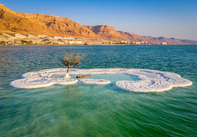
The Dead Sea is a large lake that borders Israel, Jordan, and the West Bank. It has the lowest land elevation on Earth, sitting 422 meters (1,385 feet) below sea level. The white "foam" that collects on the shores of the Dead Sea is actually salt.

The Dead Sea has the lowest elevation and is the lowest body of water on the surface of Earth. For several decades in the mid-20th century, the standard value given for the surface level of the lake was some 1,300 feet (400 metres) below sea level. Beginning in the 1960s, however, Israel and Jordan began diverting much of the Jordan River’s flow and increased the use of the lake’s water itself for commercial purposes. The result of those activities was a precipitous drop in the Dead Sea’s water level. By the mid-2010s, measurement of the lake level was more than 100 feet (some 30 metres) below the mid-20th-century figure—i.e., about 1,410 feet (430 metres) below sea level—but the lake continued to drop by about 3 feet (1 metre) annually.

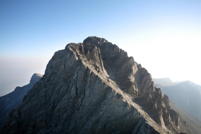
The Dead Sea region occupies part of a graben (a downfaulted block of Earth’s crust) between transform faults along a tectonic plate boundary that runs northward from the Red Sea–Gulf of Suez spreading centre to a convergent plate boundary in the Taurus Mountains of southern Turkey. The eastern fault, along the edge of the Moab Plateau, is more readily visible from the lake than is the western fault, which marks the gentler Judaean upfold.

In the Jurassic and Cretaceous periods (about 201 million to 66 million years ago), before the creation of the graben, an extended Mediterranean Sea covered Syria and Palestine. During the Miocene Epoch (23 million to 5.3 million years ago), as the Arabian Plate collided with the Eurasian Plate to the north, upheaval of the seabed produced the upfolded structures of the Transjordanian highlands and the central range of Palestine, causing the fractures that allowed the Dead Sea graben to drop. At that time the Dead Sea was probably about the size that it is today. During the Pleistocene Epoch (2,588,000 to 11,700 years ago), it rose to an elevation of about 700 feet (200 metres) above its modern level, forming a vast inland sea that stretched some 200 miles (320 km) from the H?ula Valley area in the north to 40 miles (64 km) beyond its present southern limits. The Dead Sea did not spill over into the Gulf of Aqaba because it was blocked by a 100-foot (30-metre) rise in the highest part of Wadi Al-?Arabah, a seasonal watercourse that flows in a valley to the east of the central Negev highlands.

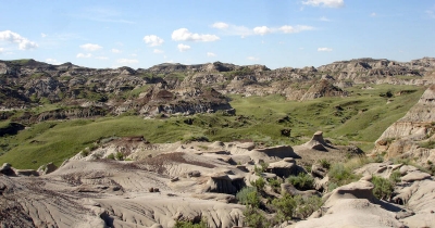
Beginning about 2.5 million years ago, heavy streamflow into the lake deposited thick sediments of shale, clay, sandstone, rock salt, and gypsum. Later, strata of clay, marl, soft chalk, and gypsum were dropped onto layers of sand and gravel. Because the water in the lake evaporated faster than it was replenished by precipitation during the past 10,000 years, the lake gradually shrank to its present form. In so doing, it exposed deposits that now cover the Dead Sea valley to thicknesses of between about 1 and 4 miles (1.6 and 6.4 km).

Credit :  Britannica 

Picture Credit : Google

Where is Mount Mckinley located?

Denali, also called Mount McKinley, highest peak in North America. It is located near the centre of the Alaska Range, with two summits rising above the Denali Fault, in south-central Alaska, U.S.

Denali’s official elevation figure of 20,310 feet (6,190 metres), established by the United States Geological Survey in September 2015, was the product of a thorough remeasurement of the mountain’s height conducted earlier that year using state-of-the-art equipment. The new value superseded the long-standing figure of 20,320 feet (6,194 metres) that had been the official elevation since the early 1950s. Earlier attempts to measure the mountain’s height had yielded different values. One such survey, conducted in 2010 using advanced radar technology, was made public in September 2013 and gave its elevation as 20,237 feet (6,168 metres). However, that measurement was subsequently determined to be inaccurate.

Denali lies about 130 miles (210 km) north-northwest of Anchorage and some 170 miles (275 km) southwest of Fairbanks in Denali National Park and Preserve. The mountain is essentially a giant block of granite that was lifted above Earth’s crust during a period of tectonic activity that began about 60 million years ago. It rises abruptly some 18,000 feet (5,500 metres) from Denali Fault at its base to the higher, more southerly of its two summits. The upper half of the mountain is covered with permanent snowfields that feed many glaciers, some surpassing 30 miles (48 km) in length.

Credit : Britannica 

Picture Credit : Google

Where are Galapagos Islands located?

Galapagos Islands are island group of the eastern Pacific Ocean, administratively a province of Ecuador. The Galapagos consist of 13 major islands (ranging in area from 5.4 to 1,771 square miles [14 to 4,588 square km]), 6 smaller islands, and scores of islets and rocks lying athwart the Equator 600 miles (1,000 km) west of the mainland of Ecuador. Their total land area of 3,093 square miles (8,010 square km) is scattered over 23,000 square miles (59,500 square km) of ocean. The government of Ecuador designated part of the Galapagos a wildlife sanctuary in 1935, and in 1959 the sanctuary became the Galapagos National Park. In 1978 the islands were designated a UNESCO World Heritage site, and in 1986 the Galapagos Marine Resources Reserve was created to protect the surrounding waters. The Charles Darwin Research Station on Santa Cruz (Indefatigable) Island promotes scientific studies and protects the indigenous vegetation and animal life of the Galapagos.

The Galapagos Islands are formed of lava piles and dotted with shield volcanoes, many of which are periodically active. The striking ruggedness of the arid landscape is accentuated by high volcanic mountains, craters, and cliffs. The largest of the islands, Isabela (Albemarle), is approximately 82 miles (132 km) long and constitutes more than half of the total land area of the archipelago; it contains Mount Azul, at 5,541 feet (1,689 metres) the highest point of the Galapagos Islands. The second largest island is Santa Cruz.

The climate of the Galapagos Islands is characterized by low rainfall, low humidity, and relatively low air and water temperatures. The islands have thousands of plant and animal species, of which the vast majority are endemic. The archipelago’s arid lowlands are covered by an open cactus forest. A transition zone at higher elevations is covered with a forest in which pisonia (a four o’clock plant) and guava trees dominate, and the moist forest region above the transition zone is dominated by a Scalesia forest with dense underbrush. The treeless upland zone is covered with ferns and grasses.

Credit :  Britannica 

Picture Credit : Google

Where is Ayers Rock located?

Uluru/Ayers Rock, giant monolith, one of the tors (isolated masses of weathered rock) in southwestern Northern Territory, central Australia. It has long been revered by a variety of Australian Aboriginal peoples of the region, who call it Uluru. The rock was sighted in 1872 by explorer Ernest Giles and was first visited by a European the following year, when surveyor William Gosse named it for Sir Henry Ayers, a former South Australian premier. It is the world’s largest monolith. (Mount Augustus [Burringurrah] in Western Australia is often identified as the world’s largest monolith, but, because it is composed of multiple rock types, it is technically not a monolith.)

Despite the seeming harshness of the climate, the landscape around the monolith supports a variety of flora and fauna. There are about 400 species of plants in the national park, including mulga trees (a type of acacia), desert oaks and desert poplars, and several types of eucalyptus, especially centralian bloodwoods (Corymbia opaca); shrubs, notably species of Grevillea; and dozens of types of wildflowers, including foxtails and myrtles. Wildlife includes mammals such as red kangaroos (Macropus rufus), a variety of rodents and small marsupials, and the rare rufus hare wallaby (Lagorchestus hirsutus); numerous reptiles and amphibians, particularly lizards such as geckos and skinks, snakes (including such highly poisonous varieties as the death adder), and the indigenous moloch (thorny devil); and some 175 species of birds, notably falcons, buzzards, budgerigars (a species of parakeet), and honeyeaters.

Uluru/Ayers Rock is one of Australia’s best-known tourist destinations. Most visitors arrive there via Alice Springs, about 280 miles (450 km) northeast by road, although there are scheduled flights to a small airport at Yulara, a community just north of the national park boundary. Yulara also has hotel, hostel, and camping accommodations, as well as restaurants and other guest services; there are no overnight facilities within the park. The park is accessible by road from Yulara, and a road connects the Uluru/Ayers Rock area with the Olgas formations. Hiking around the base of the rock is a popular activity, as is climbing up the rock itself. However, the local Aboriginal people have strongly encouraged people not to climb on it. A cultural centre near the base of the monolith has exhibits that introduce visitors to Aboriginal society and culture.

Credit : Britannica 

Picture Credit : Google

Where is White Cliffs of Dover located?

The famous White Cliffs of Dover stand guard at the Gateway to England. Millions pass through Dover each year on their journey to or from the continent. In some places over 300 feet high, the White Cliffs are a symbol of the United Kingdom and a reassuring sight to travellers. The Cliffs have been immortalised in song, in literature and in art.

On a clear day you can see right across from the Dover cliffs to the cliffs on the French coast at Cap Gris Nez, proof of the continuous strata of chalk.

Around seventy million years ago this part of Britain was submerged by a shallow sea. The sea bottom was made of a white mud formed from the fragments of coccoliths, which were the skeletons of tiny algae which floated in the surface waters of the sea. This mud was later to become the chalk. It is thought that the chalk was deposited very slowly, probably only half a millimetre a year, equivalent to about 180 coccoliths piled one on top of another. In spite of this, up to 500 metres of chalk were deposited in places. The coccoliths are too small to be seen without a powerful microscope but if you look carefully you will find fossils of some of the larger inhabitants of the chalk sea such as sponges, shells, ammonites and urchins.

Since the time of the chalk sea, the chalk has been lifted out of the water by movements of the earth's crust. Most of the shaping of the beautiful chalk downlands we see today took place during the last Ice Age. The latter part of the Ice Age also saw the invasion of chalk by the English Channel. The consequence of this was that Britain became an island.

Credit : Dover Museum

Picture Credit : Google

Where is Dinosaur Provincial Park located?

Dinosaur Provincial Park, public park located in the badlands of southeastern Alberta, Canada. The nearly 29-square-mile (75-square-km) park is best known for its extensive fossil beds, within which have been identified some 35 different species of dinosaurs from the Late Cretaceous Epoch (about 100 to 65 million years ago). There are also fossilized remains of Cretaceous fish, reptiles, and amphibians. The area, originally created as the Steveville Dinosaur Provincial Park in 1955, was designated a UNESCO World Heritage site in 1979 for its diversity of plant and animal life as well as for its paleontological value.

During the Late Cretaceous, the area of the modern park was a swampy river delta containing a dense subtropical forest of palms and giant redwoods. Over the course of time, silt deposited by the river became sedimentary rock that preserved dinosaur remains. Glaciers later carved out the badlands, exposing the fossil beds. The present-day landscape is intersected by Red Deer River and constitutes habitat considered part of an endangered riverine ecosystem. Willows and cottonwoods thrive along the river, while cacti and grasses grow in the arid badlands. Antelope and deer graze in these grassy regions, and the land also supports coyotes, rabbits, and more than 150 species of birds.

Dinosaur bones were discovered in the area as early as the 1880s, and three decades later large-scale excavations were begun by the fossil hunters Barnum Brown (1910–15) and Charles H. Sternberg (1911–17). Paleontologists have found skeletal remains in the rich fossil beds of each of the dinosaur families known to have existed in the Late Cretaceous. In 1985 the Royal Tyrrell Museum of Palaeontology opened in Drumheller, 60 miles (100 km) to the northwest, to facilitate the analysis and reconstruction of the dinosaurs; one of the museum’s displays is the partial skeleton of a Tyrannosaurus rex. The Royal Tyrrell Museum also operates a field station within the park to store and catalog bones from ongoing excavations. Work in the 1990s included the excavation of a nearly complete skeleton of Albertosaurus libratus, a member of the tyrannosaur group; two significant ceratopsian bonebeds; a complete skull of Centrosaurus apertus, a horned dinosaur; several ankylosaur skulls; a skeleton of the extinct ray-fish Myledaphus; and a multigeneric deposit of more than 1,500 bones representing dinosaurs, crocodilians, amphibians, pterosaurs, and birds.

Credit : Britannica 

Picture Credit : Google

Where is Mount Olympus located?

Mount Olympus is the highest mountain in Greece, located in the northeast of the country in the region of Thessaly about 100 km (60 miles) south west of the city of Thessaloniki. The mountain was the first area in Greece which was declared as a National Park in 1938.
The highest peak of Mount Olympus is Mytikas with 2,919 m (9,577 ft).

In Greek and Roman mythology the mountain is the residence of the twelve ancient gods. The gods live in ravines, “the mysterious folds of Olympus” according to Homer, there they have their palaces.
The Pantheon (today’s Mytikas) is their meeting place. On Mount Olympus there is the Plateau of the Muses, home to the goddesses of inspiration of literature, science, and the arts. And there is the mythical site of Leibethra, where Orpheus was buried. On the mountain's third highest summit (Stefani) the throne of the god of gods, the supreme ruler of the Olympians: Zeus (Jupiter), he is the god of the sky, the relevant authority for lightning and thunder, law, order, and justice. As the chieftain of the gods, he also assigns the various gods and goddesses their roles.

Credit : Nations Online 

Picture Credit : Google

Where is the Sahara located?

Sahara is the largest desert in the world. Filling nearly all of northern Africa, it measures approximately 3,000 miles (4,800 km) from east to west and between 800 and 1,200 miles from north to south and has a total area of some 3,320,000 square miles (8,600,000 square km); the actual area varies as the desert expands and contracts over time. The Sahara is bordered in the west by the Atlantic Ocean, in the north by the Atlas Mountains and Mediterranean Sea, in the east by the Red Sea, and in the south by the Sahel—a semiarid region that forms a transitional zone between the Sahara to the north and the belt of humid savannas to the south.

The Sahara is dominated by two climatic regimes: a dry subtropical climate in the north and a dry tropical climate in the south. The dry subtropical climate is characterized by unusually high annual and diurnal temperature ranges, cold to cool winters and hot summers, and two precipitation maximums. The dry tropical climate is characterized by a strong annual temperature cycle following the declination of the sun; mild, dry winters; and a hot dry season preceding variable summer rains. A narrow strip of the western coastal zone has a relatively cool, uniform temperature reflecting the influence of the cold Canary Current.

Credit :  Britannica 

Picture Credit : Google

Where is Grand Canyon located?

Grand Canyon, immense canyon cut by the Colorado River in the high plateau region of northwestern Arizona, U.S., noted for its fantastic shapes and coloration.

The Grand Canyon lies in the southwestern portion of the Colorado Plateau, which occupies a large area of the southwestern United States and consists essentially of horizontal layered rocks and lava flows. The broad, intricately sculptured chasm of the canyon contains between its outer walls a multitude of imposing peaks, buttes, gorges, and ravines. It ranges in width from about 175 yards (160 metres) to 18 miles (29 km) and extends in a winding course from the mouth of the Paria River, near Lees Ferry and the northern boundary of Arizona with Utah, to Grand Wash Cliffs, near the Nevada state line, a distance of about 277 miles (446 km); the first portion of the canyon—from Lees Ferry to the confluence with the Little Colorado River—is called Marble Canyon. The Grand Canyon also includes many tributary side canyons and surrounding plateaus.

Terrestrial plant and animal fossils are not abundant in the Grand Canyon’s sedimentary rocks because of the age of the rocks. Fossils are mostly of primitive algae and such marine species as mollusks, corals, trilobites, and other invertebrates.

Animal life in the Grand Canyon area today, however, is varied and abundant. Common mammals are the many varieties of squirrels, coyotes, foxes, deer, badgers, bobcats, rabbits, chipmunks, and kangaroo rats. In addition, the canyon region is home to a great many bird species, including raptors such as bald eagles and peregrine falcons and the rare California condor. Fish species include trout and (in the Little Colorado River) the rare humpback chub (Gila cypha).

Plant life is also varied. In the bottom of the canyon, where temperatures in the summer can reach a high of 120 °F (49 °C), are willows and cottonwoods, which require abundant water during the growing season. Drought-resistant plants include tamarisks, yuccas, agaves, and numerous species of cactus. Efforts have been made to eradicate stands of the invasive tamarisk. On the canyon rims, north and south, there is a wide assortment of plant life. Typical of the South Rim, which receives about 15 inches (380 mm) of precipitation annually, is a well-developed ponderosa pine forest, with scattered stands of piñon pine and juniper. Bush vegetation consists mainly of scrub oak, mountain mahogany, and large sagebrush. On the North Rim, which receives 26 inches (660 mm) of precipitation annually, are magnificent forest communities of ponderosa pine, white and Douglas fir, blue spruce, and aspen. Under less optimum conditions the plant life reverts to the desert varieties.

Credit : Britannica 

Picture Credit : Google

Where is Great Barrier Reef located?

Stretching for 1,429 miles over an area of approximately 133,000 square miles , the Great Barrier Reef is the largest coral reef system in the world. The reef is located off the coast of Queensland, Australia, in the Coral Sea.

The reef, which is large enough to be visible from space, is made up of nearly 3,000 individual reefs. Much of the Great Barrier Reef is a marine protected area, managed by the Great Barrier Reef Marine Park Authority of Australia.

The reef actually consists of some 2,100 individual reefs and some 800 fringing reefs (formed around islands or bordering coastlines). Many are dry or barely awash at low tide; some have islands of coral sand, or cays; and others fringe high islands or the mainland coast. In spite of this variety, the reefs share a common origin: each has been formed, over millions of years, from the skeletons and skeletal waste of a mass of living marine organisms. The “bricks” in the reef framework are formed by the calcareous remains of the tiny creatures known as coral polyps and hydrocorals, while the “cement” that binds these remains together is formed in large part by coralline algae and bryozoans. The interstices of this framework have been filled in by vast quantities of skeletal waste produced by the pounding of the waves and the depredations of boring organisms.

Forms of life include at least 450 species of hard coral as well as anemones, sponges, worms, gastropods, lobsters, crayfish, prawns, and crabs. More than 1,500 species of fishes and other vertebrates inhabit the reef. Some of the most common fishes include wrasses, damselfish, triggerfish, and angelfish, and larger species include rays and sharks (e.g., tiger sharks and whale sharks, the largest living fish). The reef is also home to six of the seven known species of sea turtles, more than a dozen sea snakes, and nearly two dozen species of birds.

Credit : Britannica 

Picture Credit : Google

Where is Niagara Falls located?

Niagara Falls is a group of three waterfalls at the southern end of Niagara Gorge, spanning the border between the province of Ontario in Canada and the state of New York in the United States.

Comprised of three waterfalls — American Falls, Horseshoe Falls and Bridal Veil Falls — Niagara Falls water stems from the upper Great Lakes and the river is estimated to be 12,000 years old. The wonder of the falls has intrigued many and has prompted daredevils to “conquer” the falls in various contraptions from wooden barrels to rubber balls.

Niagara Falls consists of two waterfalls on the Niagara River, which marks the border between New York and Ontario, Canada: the American Falls, located on the American side of the border, and the Canadian or Horseshoe Falls located on the Canadian side. To the right of the American Falls is a smaller waterfall that has been separated from the American Falls by natural forces, which is usually called Bridal Veil Falls.

It is estimated that 12,000 years ago when the falls were formed, the edge of the falls was as much as seven miles further down river than it is today. Until the 1950s, when the flow of water began to be controlled, the brink of the falls moved backward an estimated three feet every year because of erosion.

The water that runs over the falls comes from the Great Lakes. Ninety percent of the water goes over the Horseshoe Falls. Originally, as much as 5.5. billion gallons of water per hour flowed over the falls. Today the amount is controlled by the Canadian and American governments to slow erosion. In addition, some of the water is diverted to provide power for the United States and Canada, making Niagara Falls the largest source of electric power in the world.

The Horseshoe Falls are 170 feet high. The brink of the falls is approximately 2,500 feet from one side to the other. The American Falls are 180 feet high and 1,100 feet long.

The river below Niagara Falls averages 170 feet deep. Daredevils who go over the falls usually hit the bottom of the river before popping back to the surface.

Credit : History 

Picture Credit : Google

Petra city is carved into a cliff made of which natural material?

Petra is filled with spectacular tombs, monuments, and houses that were carved into the sandstone  cliffs. These elaborate structures were chiseled by hand out of the rose-red rocks, then covered with stucco and painted bright colors.

The people of Petra liked to show off their wealth and hired master builders to create these masterpieces. Starting from the top down, builders chiseled the detailed designs by hand right into the sandstone cliffs. The design of the massive columns, grand staircases, and classical statues show the influence of contact with Greece and Rome.

Winding roads, stairways, and water channels were also cut along the natural curves of cliffs and canyons.

But the most breathtaking "road" in the city wasn't carved by humans. The Siq , the narrow, winding gorge that led into Petra, is a natural wonder.

Credit : AMNH

Picture Credit : Google

The world's longest structure ever made by humans, the Great Wall stretches about how far?

Great Wall of China, Chinese (Pinyin) Wanli Changcheng or (Wade-Giles romanization) Wan-li Ch’ang-ch’eng (“10,000-Li Long Wall”), extensive bulwark erected in ancient China, one of the largest building-construction projects ever undertaken. The Great Wall actually consists of numerous walls—many of them parallel to each other—built over some two millennia across northern China and southern Mongolia. The most extensive and best-preserved version of the wall dates from the Ming dynasty (1368–1644) and runs for some 5,500 miles (8,850 km) east to west from Mount Hu near Dandong, southeastern Liaoning province, to Jiayu Pass west of Jiuquan, northwestern Gansu province. This wall often traces the crestlines of hills and mountains as it snakes across the Chinese countryside, and about one-fourth of its length consists solely of natural barriers such as rivers and mountain ridges. Nearly all of the rest (about 70 percent of the total length) is actual constructed wall, with the small remaining stretches constituting ditches or moats. Although lengthy sections of the wall are now in ruins or have disappeared completely, it is still one of the more remarkable structures on Earth. The Great Wall was designated a UNESCO World Heritage site in 1987.

Large parts of the fortification system date from the 7th through the 4th century BCE. In the 3rd century BCE Shihuangdi (Qin Shihuang), the first emperor of a united China (under the Qin dynasty), connected a number of existing defensive walls into a single system. Traditionally, the eastern terminus of the wall was considered to be Shanhai Pass (Shanhaiguan) in eastern Hebei province along the coast of the Bo Hai (Gulf of Chihli), and the wall’s length—without its branches and other secondary sections—was thought to extend for some 4,160 miles (6,700 km). However, government-sponsored investigations that began in the 1990s revealed sections of wall in Liaoning, and aerial and satellite surveillance eventually proved that this wall stretched continuously through much of the province. The greater total length of the Ming wall was announced in 2009.

Picture Credit : Google

At certain times of year, the sunset casts shadow on Chichen Itza Mayan pyramid, creating the appearance of what kind of animal slithering down its stairs?

El Castillo—in Spanish, “the castle”—looms at the center of Chichén Itzá, a 79-foot pyramid of stone. Also known as the Pyramid of Kukulkán, the structure embodies Mayan myth along with natural astronomical cycles.

The phenomenon that El Castillo is famous for occurs twice each year, at the spring and fall equinoxes. (In fact, the effect is viewable for a week before and after each equinox.) As the equinox sun sets, a play of light and shadow creates the appearance of a snake that gradually undulates down the stairway of the pyramid. This diamond-backed snake is composed of seven or so triangular shadows, cast by the stepped terraces of the pyramid. The sinking sun seems to give life to the sinuous shadows, which make a decidedly snaky pattern on their way down the stairs.

Using the patterns of light and shadow appearing on El Castillo throughout the year, the Maya could easily have tracked the seasons and marked these four annual solar events—the two solstices and two equinoxes. And so it seems the ancient Maya may have used this structure as, among other things, a calendar to signal appropriate times to plant, harvest, and perform ceremonies.

Credit : Exploratorium 

Picture Credit : Google

What is the name of the mountain on which the Christ the Redeemer statue stands?

Christ the Redeemer, Portuguese Cristo Redentor, colossal statue of Jesus Christ at the summit of Mount Corcovado, Rio de Janeiro, southeastern Brazil. Celebrated in traditional and popular songs, Corcovado towers over Rio de Janeiro, Brazil’s principal port city. The statue of Christ the Redeemer was completed in 1931 and stands 98 feet (30 metres) tall, its horizontally outstretched arms spanning 92 feet (28 metres). The statue has become emblematic of both the city of Rio de Janeiro and the whole nation of Brazil.

The statue, made of reinforced concrete clad in a mosaic of thousands of triangular soapstone tiles, sits on a square stone pedestal base about 26 feet (8 metres) high, which itself is situated on a deck atop the mountain’s summit. The statue is the largest Art Deco-style sculpture in the world.

In the 1850s the Vincentian priest Pedro Maria Boss suggested placing a Christian monument on Mount Corcovado to honour Isabel, princess regent of Brazil and the daughter of Emperor Pedro II, although the project was never approved. In 1921 the Roman Catholic archdiocese of Rio de Janeiro proposed that a statue of Christ be built on the 2,310-foot (704-metre) summit, which, because of its commanding height, would make it visible from anywhere in Rio. Citizens petitioned Pres. Epitácio Pessoa to allow the construction of the statue on Mount Corcovado.

Credit : Britannica

Picture Credit : Google