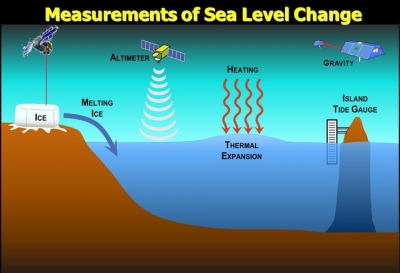
Tide gauge is among the oldest methods to measure sea level. A tide gauge is fitted with sensors and placed on piers. It continuously records the height of the surrounding water level. Water older tide-measuring stations used mechanical floats and recorders, modern monitoring stations use advanced acoustics and electronics. Sea level is also measured from space using laser altimeters, which determine the height of the sea surface by measuring the return speed and intensity of a laser pulse directed at the ocean. The higher the sea level, the faster and stronger the return signal is.
You can see that getting an accurate reading (for example, down to the millimeter level) is extremely difficult. Satellites are now used as well, but they suffer from many of the same problems. Scientists do the best they can, using extremely long time spans, to try to figure out what the sea level is and whether or not it is rising. The general consensus seems to be that the oceans rise about 2 millimeters per year.
Picture Credit : Google