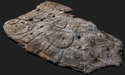
According to media reports in April 2021, a Bronze-Age stone unearthed in France was confirmed to be the oldest three-dimensional map in Europe. The five-ft-by-6.5-ft slab, first uncovered in 1900 and forgotten, was found again in a cellar in a castle in 2014. Archaeologists who studied patterns engraved on the 4,000-year-old stone said they believe the markings were the map of an area in western Brittany.
After analysing marks and engravings on the stone, the researchers suspected it could be a map.
The “presence of repeated motifs joined by lines” on its surface suggested it depicted an area of Finistere, a study in the Bulletin of the French Prehistoric Society said.
The researchers say the indentations are a 3D representation of the River Odet valley, while several lines appear to depict the area’s river network.
Geo-location revealed the territory represented on the slab bears an 80% accuracy to an area around an 18 mile-long stretch of the river.
“This is probably the oldest map of a territory that has been identified,” Dr Clement Nicolas from Bournemouth University, one of the study’s authors, told the BBC.
“There are several such maps carved in stone all over the world. Generally, they are just interpretations. But this is the first time a map has depicted an area on a specific scale.”
Dr Nicolas said the map may have been used to mark a particular area.
“It was probably a way to affirm the ownership of the territory by a small prince or king at the time,” he said.
“We tend to underestimate the geographical knowledge of past societies. This slab is important as it highlights this cartographical knowledge.”
Credit : BBC
Picture Credit : Google


