What are the interesting facts about the Qutub Minar and other monuments in the Qutb Complex?


The Qutb complex in Delhi contains buildings and monuments from the Delhi Sultanate era. Amongst these is the Qutub Minar, built as a victory tower by Qutb-ud-din Aibak, who was once the Sultan of Delhi. The tower commemorates the victory of the Delhi Sultanate over the Hindu kings. Several monuments were added to the complex later by his successors and future rulers. Today, the complex is a popular tourist spot in the capital and a UNESCO World Heritage Site.


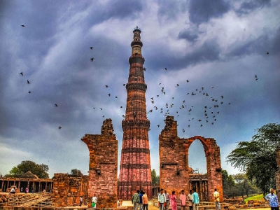
1. Tallest brick minaret


Standing at 72.5 metres, the Qutub Minar is the tallest brick minaret in the world. It has a base diameter of 14.3 metres which reduces to 2.7 metres at the peak. The Minaret of Jam in Afghanistan is the next tallest brick monument at 62 metres. Interestingly, the Qutub Minar is said to have been inspired by the Minaret of Jam.


2. No more climbing to the top


There are 379 steps that lead to the top of the Qutub Minar. It was once allowed for the public to climb the stairs and catch a glimpse of the city from the top. However, on December 4. 1981, a power failure caused a blackout at the staircase, leading to a stampede. Nearly 300 to 400 people were inside when the blackout happened and in the rush to the exit. 47 people, mostly school children, were killed. Ever since, no one has been allowed to climb the monument.


3. The oldest mosque


The Quwwat-ul-Islam Mosque, which is part of the Qutb complex was commissioned by Qutb-ud-din-Aibak. It was the first mosque to be built in Delhi after the Islamic conquest of India. The mosque is one of the oldest mosques in the country and the oldest surviving example of Ghurid architecture in the Indian subcontinent.


4. Khilji's incomplete dream


Emperor Alauddin Khilji of the Khilji dynasty enlarged the Quwwat ul-Islam Mosque during his reign. Post this, he wished to build a minaret of his own called the Alai Minar. This was to be double the size of the Qutub Minar. The construction of this minar was however abandoned after his death in 1316, and the 24.5 metre high first storey core of the minar still stands among the ruins of the Qutb complex.


5. The iron pillar


The Iron Pillar of Delhi is part of the Quth complex. It was constructed by emperor Chandragupta II and was erected elsewhere before being moved to its present location. The pillar is famous for the rust-resistant composition of metals used in its construction. Till date, the pillar has not corroded.


Picture Credit : Google


What makes the Port Arthur Historic Site famous?


The Port Arthur Historic Site is an open-air museum in Australia’s Tasman Peninsula. It is a part of the Australian Convict Sites, a World Heritage Site consisting of 11 former penal sites built during the 19th and 20th centuries. Australia had been a British colony at the time. Located along the coastal strip, these sites are an important part of Australia’s history and culture. Port Arthur became a UNESCO World Heritage Site in 2010 as a part of the Australian Convict Sites.


Port Arthur was named after George Arthur, lieutenant governor of Van Diemen’s Land. It has around 30 buildings, ruins and restored homes dating back to the early 19th century. Though Port Arthur began as a timber station, it became a colony for convicts from 1830 to 1877. Nearly 12,500 prisoners had served their sentences-here. One of the most horrific events related to this site is the Port Arthur Massacre of 1996, when a mass shooter named Martin Bryant killed 35 people and left 25 injured. Port Arthur gets around 250,000 visitors every year, making it one of the most popular historical sites in Australia.


Picture Credit : Google


Why is it said that the Greater Blue Mountains Area is unique?


The Greater Blue Mountains Area in Blue Mountains of New South Wales, Australia is a 25,51,730-acre national park. The site has eight protected areas. There are many valuable examples of evolutionary adaptation present here. The aboriginal heritage sites and post-European settlements add to the cultural importance of the park. The site is managed by the Australian government and the state of New South Wales.


Most of the park consists of temperate Eucalyptus forest. The 1500 and more plant species found here include many rare plants. The flora of the Greater Blue Mountains Area shows the different stages in the evolution of Australia’s famous gum trees. In 1994, Wollemi pine, also known as dinosaur tree or living fossil, which was believed to be extinct, was found in this site. The diverse geographical features found in the park include sandstone cliffs, slot canyons and waterfalls.


Picture Credit : Google


What are the special features of the Purnululu National Park?


The Purnululu National Park is a 350-million-year- vow old site located in East Kimberly region of Western Australia. The Aboriginals have been protectors of this land for 40,000 years.


The park has orange and black striped karst sandstone domes called the Bungle Bungles Range. The range, also known as Bungle Bungles, is often compared to a large beehive. They make a striking image, rising 250 metres above the surrounding savanna grassland. Bungle Bungles was unknown to the outside world until 1983. It is now one of the most popular tourist attractions of the region.


Purnululu was declared a World Heritage Site in 2003. Since then, the areas next to the park including the Purnululu Conservation Park and the Ord River Regeneration Reserve have also been declared as special areas by the government of Western Australia.


Picture Credit : Google


Why is it said that the Kakadu National Park is a representation of Australia's aboriginal culture?


Australia’s biggest National Park, Kakadu, has been continuously inhabited by Aboriginal people from 20,000 to 40,000 years ago. This cultural site also has waterfalls, rainforests, wetlands and exotic wildlife. The park covers 20,000 square kilometres, which is roughly half the size of Switzerland. It has 5000 art sites giving proof of thousands of years of aboriginal culture. The Ranger uranium mine is surrounded by the park. This is one of the most productive uranium mines in the world. The Kakadu National Park was designated a UNESCO World Heritage Site in 1981.


Picture Credit : Google


What is the significance of the Royal Exhibition Building?


The Royal Exhibition Building in Melbourne, Victoria, Australia is the oldest remaining exhibition pavilion. It was built in 1879-80 for the Great Exhibition of 1880. The building showcases the prosperity of Victoria in the 1870s. The same building had also housed the Commonwealth Parliament in 1901.


Though many parts of the Royal Exhibition Building were destroyed at various times during the twentieth century, its Great Hall survived. The structure, including large galleries and high domes, was restored in the 1990s.


The location continues to be used for trade shows, fairs and other events. The international flower and garden show is one of the annual events held in the Great Hall. In 2004, it became the first Australian building to join the list of UNESCO World Heritage Sites.


Picture Credit : Google


Why Fraser Island is called an unusual island?


Fraser Island is the largest sand island in the world. It is protected as a part of the Great Sandy National Park. The name of the island had been Great Sandy Island for a short period. Then the present name was adopted from the stories of a woman named Eliza Fraser who survived a shipwreck on the island.


The island is filled with the most unusual natural phenomena. For instance, it is the only place on Earth where rainforests grow on sand dunes, rising to more than 200 metres. Half of the perched lakes in the world can also be found here. These are formed when depressions on dunes are permanently filled with rainwater. Fraser Island is home to the purest strain of dingoes in Eastern Australia.


Humans have lived on Fraser Island for nearly 5000 years. Explorer James Cook sailed by the island in 1770 and Matthew Flinders landed near the northern tip of the island in 1802. Added to the UNESCO World Heritage List in 1992, the island is a popular tourist destination. In addition to the spectacular scenery, it is also a great spot to watch female humpback whales and their babies.


Picture Credit : Google


Why is the Sydney Opera House one of the most photographed buildings in the world?


The opera house in Port Jackson or Sydney Port of New South Wales, Australia is an iconic building with a roof made of sail-shaped shells. This unique structure makes it one of the most photo-graphed buildings in the world. The design of the Opera House was chosen out of 233 designs received as a part of the Opera House international design competition conducted in 1956. The winning design was submitted by Jorn Utzon of Denmark who was given prize money of £5000. The Australian architectural team led by Peter Hall constructed the building. Initially estimated to cost 7 million Australian dollars, the structure’s final cost of construction was nearly 102 million, which was mainly paid for by the State Lottery. The opera house formally opened on 20th October 1973.


There are multiple performance venues in the Sydney Opera House. 1500 performances are conducted here every year, which are attended by over 1.2 million people.


The Sydney Opera House is located on Bennelong Point, named after Woollarawarre Bennelong. He was a senior Aboriginal man of the Eora clan when the British colonisers came to Australia in 1788.


The Sydney Opera House was added to the UNESCO list of World Heritage Sites in 2007. The building is managed by the Sydney Opera House Trust of the New South Wales state government.


Picture Credit : Google


What makes Australia special? What is the significance of the Great Barrier Reef in Australia?


The continent of Australia includes mainland Australia, Tasmania and the island of New Guinea. Though New Zealand is often mistaken to be a part of the Australian continent it is actually a part of Zealandia, a continental crust that is almost completely underwater.


Spread across 344,400 square kilometres, Australia’s Great Barrier Reef is the largest coral reef system and the biggest living structure on earth. It is so large that it can be seen from outer space. UNESCO designated the Great Barrier Reef as a World Heritage Site in 1981. It is also one of the seven natural wonders of the world.


The reef is located in the Coral Sea near the coast of Queensland in Australia. It is home to an astonishing variety of marine plants and animals. Ancient sea turtles, reef fish, 134 species of sharks and rays are some of the sea animals found here. The reef also has at least 400 different hard and soft corals and a wide variety of seaweeds. The Great Barrier Reef marine park protects a large part of the reef from human impact. However, climate change, mass coral bleaching, dumping of sludge and cyclic population outbreaks of the crown-of-thorns starfish are some of the environmental concerns faced by the Reef.


Picture Credit : Google


What is the significance of Twyfelfontein?


Twyfelfontein, designated in 2007, is the first UNESCO World Heritage Site of Namibia. Located in northwest Namibia’s Kunene Region, this site has over 5000 individual petroglyphs or rock engravings. Until Namib Sand Sea was designated in 2013, Twyfelfontein had been the only World Heritage Site in Namibia.


Twyfelfontein contains a spring with slopes of sandstone Table Mountains on both sides. This place receives very little rainfall and experiences a wide range of temperatures. Humans have lived in this site for 6000 years. It was first inhabited by hunter gatherers and later by Khoikhoi herders. There are over 2500 rock carvings and a few rock paintings in Twyfelfontein indicating that the inhabitants had used it as a place of worship and to conduct rituals of shamanism.


There are many engravings depicting animals like elephants, rhinos, giraffes and lions but these animals are no longer found in the area. Twyfelfontein’s connection with the coastal area located 100 km away is evident by the engraving of a sea lion.


The site became a National Monument in 1952 and was designated a natural reserve in 1986. By the time it received protection as a natural reserve, many petro-glyphs of Twyfelfontein had been damaged or removed.


Picture Credit : Google


What is the role of Lake Malawi in the study of evolution?


The Lake Malawi National Park in Malawi, south eastern Africa, is the first freshwater national park in the world. Located at Cape Maclear, towards the southern end of Lake Malawi, this National Park was made to protect fish and aquatic habitats. The Malawi government has made laws to protect the park and its management is under the Department of National Parks and Wildlife.


Hundreds of species of endemic aquatic animals live in these waters. The fish called mbuna, found abundantly in these waters is an important example of biological evolution. Lake Malawi is not connected to other water bodies. As a result of this isolation, its fishes have evolved into many different forms and species.


The mountains of the park are filled with animal and birds. Animals like baboons, antelope, hyrax and birds such as fish eagles, cormorants and hamerkops are found in the Lake Malawi National Park. It was designated a UNESCO World Heritage Site in 1984.


Picture Credit : Google


What makes the Serengeti National Park a prominent natural heritage site?


The Serengeti National Park is a large grassland range and an acacia woodland savanna in Tanzania. It is the only remaining place in Africa where large scale land-animal migrations still occur. The park was established in 1951 and covers an area of 14,763 square kilometres. The Serengeti National Park is located at the heart of the Serengeti Ecosystem which includes the Ngorongoro conservation area and the Maasai Mara National Reserve which borders Kenya. The park is home to threatened or endangered species like black rhinoceros, elephant, wild dog and cheetah and to herds of wildebeest, gazelles and zebras.


The Serengeti National Park was added to the NESCO World Heritage I in 1981. Increased tourism, poaching, wildfires and inadequate monitoring of resources are some of the challenges faced by the National Park. Water is also a concern in the management of the park. Though water sources are available during rainy season, the only perennial river is the Mara, which flows through the park.


Picture Credit : Google


What are the features of the Stone Town?


The Stone Town of Zanzibar, Tanzania combines elements from different cultures of Africa, the Arab region, India and Europe. UNESCO designated this East African city as a World Heritage Site in 2000.


The buildings and layout of the town are still preserved in its true form. The narrow winding streets and large seafront mansions of Stone Town reflect the cultural impact made by hundreds of years of trade between Asia and Africa.


The houses in Zanzibar have intricately carved wooden doors. Often, they would be fitted with brass studs showing the influence of Indian tradition. The Stone Town has also gone down in history as the place which marked the end of slave trade. Tourism in this Swahili coastal town is a main source of income for Tanzania. The new parts of the Stone Town are called Ng’ambo, meaning ‘the other side’ in Swahili.


Picture Credit : Google


What is the significance of Memphis and its Necropolis: The Pyramid Fields from Giza to Dahshur?


Memphis and its Necropolis: The Pyramid Fields from Giza to Dahshur is a burial site that shaped the culture and history of Egypt. Located on the west bank of the River Nile, these pyramids are well- known for their outstanding construction methods.


The Pharaohs of Egypt believed that they would become gods after their death. To prepare for the afterlife, they built temples for the gods and huge pyramid tombs filled with treasures for themselves. The pyramids would be filled with things that each ruler needs to guide and sustain him in the next world. The pyramids of Giza in Northern Egypt are the most popular among these. They were one of the Seven Wonders of the Ancient World.


Pharaoh Khufu started the first Giza pyramid project in 2550 BC. The Great Pyramid he built is the largest in Giza, rising 147 metres above the rocky plateau. Pharaoh Khafre, the son of Khufu, built the second pyramid at Giza in 2520 BC. This included the limestone monument called the Sphinx which has the body of a lion and the head of a pharaoh.


Picture Credit : Google


What makes the old town of Ghadames special?


The city of Ghadames is located in Libya. The white buildings of Ghadames standing in contrast to the dark desert gave it the name, the ‘Pearl of the Desert.’ Ghadames was designated a UNESCO World Heritage Site in 1986.


The buildings of this traditional settlement are made of mud. This keeps the heat out during the day and retains warmth during the cold desert nights. Another special feature of the buildings in Ghadames is their structure. The first floors are used for storage while families live on the next floor. Interestingly, the rooftops of all 1300 houses in Ghadames are connected to each other. This is probably due to certain religious beliefs.


People do not live in Ghadames anymore but the Libyan government has made efforts to make it a tourist attraction and a source of income for people living in nearby areas.


Picture Credit : Google