Which is the America’s biggest river?
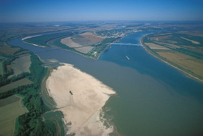
The Mississippi is about 3,760 kilometres long. With its two huge tributaries, the Missouri and the Ohio, it drains a vast area, emptying the water from thirty-one states and two Canadian provinces into the Gulf of Mexico. The enormous delta of the Mississippi starts in Louisiana, about 400 kilometres from the sea. At this place an arm of the river flows away from the main course and becomes the river Atchafalaya. Beyond this point the Mississippi opens out like a fan and develops several mouths when it reaches the sea.
The Mississippi divides the United States into two clear-cut regions. In the east lie the well-watered lands which were once covered in forests but are now intensively farmed; in the west lie the prairies which are bordered by dry, desert regions, on the slopes of the Rocky Mountains. Up to the point where it meets the Ohio River, the Mississippi follows a steep downward course and flows between rocky banks. Once it has reached the flat land of the plains, it meanders and flows very slowly. Often the surrounding land is lower is than the river itself and at these places strong ramparts and flood barriers have been built, but it has not always been possible to escape the disastrous floods that happen when the river bursts its banks. Large boats can sail up the Mississippi as far as New Orleans which is about 160 kilometres from the delta; smaller ships can go as far as Baton Rouge.
The Mississippi was discovered by Hernando de Soto in May 1541. It source, however, remained a mystery until 1832 when Henry Rowe Schodcraft found it is a small lake in Minnesota, which he named Itasca from the Latin veritas caput (true head).
Picture Credit : Google