A pointer to the predominant colour of many of its building, which Indian city is called the Pink City?


Known as the “Pink City of India” due to its distinctive pink coloured buildings, Jaipur is the largest city in the state of Rajasthan and one of India’s most stunning cities.


You may be wondering why it is called the “Pink City,” and this is all down to Maharaja Sawai Ram Singh who had the whole city painted pink in 1876, to entice Prince Albert and Queen Victoria to visit Jaipur as part of their tour of India, as pink was considered the colour of hospitality at the time.


There is so much to see in Jaipur and it has an amazing variety of palaces, forts, temples, monuments, museums, arts and crafts, and various market places to explore.


The city is known for its beauty, and it is unique in its straight-line planning. Its buildings are predominantly rose-coloured, and it is sometimes called the “pink city.” The chief buildings are the City Palace, part of which is home to the royal family of Jaipur; Jantar Mantar, an 18th-century open-air observatory that was designated a UNESCO World Heritage site in 2010; Hawa Mahal (Hall of Winds); Ram Bagh palace; and Nahargarh, the Tiger Fort. Other public buildings include a museum and a library. Jaipur is the seat of the University of Rajasthan, founded in 1947.


The city is surrounded by fertile alluvial plains to the east and south and hill chains and desert areas to the north and west. Bajra (pearl millet), barley, gram (chickpeas), pulses, and cotton are the chief crops grown in the region. Iron ore, beryllium, mica, feldspar, marble, copper, and garnet deposits are worked. In addition to Amer, other nearby attractions include Sariska National Park to the northeast.


Picture Credit : Google


Gotham, the Big Apple, the City that Never Sleeps, are among the many nicknames of which American city?


New York City is known by many nicknames—such as “the City that Never Sleeps” or “Gotham”—but the most popular one is probably “the Big Apple.” How did this nickname come about? Although uses of the phrase are documented in the early 1900s, the term first became popular in the 1920s when John J. Fitz Gerald, a sports writer, started a column about horse racing called “Around the Big Apple.” However, it wasn’t until a tourism campaign in the 1970s that the nickname came to be synonymous with New York City.


The most populous city in the U.S. also goes by the name Gotham, which was first used by Washington Irving in an 1807 issue of his literary magazine about the legends of an English village named Gotham.

New York City is frequently shortened to simply "New York", "NY", or "NYC". New York City is also known as "The City" in some parts of the Eastern United States, in particular New York State and surrounding U.S. states. Other monikers have taken the form of "Hong Kong on the Hudson" or "Baghdad on the Subway", references in different cases to the city's prominence or its immigrant groups.


Picture Credit : Google


As it was a centre of the cotton industry in the 19th Century, which city in England was earlier nicknamed Cottonopolis?


Cottonopolis was a 19th-century nickname for Manchester, as it was a metropolis and the centre of the cotton industry.


Early cotton mills powered by water were built in Lancashire and its neighbouring counties. In 1781 Richard Arkwright opened the world's first steam-driven textile mill on Miller Street in Manchester. Although initially inefficient, the arrival of steam power signified the beginning of the mechanisation that was to enhance the burgeoning textile industries in Manchester into the world's first centre of mass production. As textile manufacture switched from the home to factories, Manchester and towns in south and east Lancashire became the largest and most productive cotton spinning centre in the world using in 1871, 32% of global cotton production. Ancoats, part of a planned expansion of Manchester, became the first industrial suburb centred on steam power. There were mills whose architectural innovations included fireproofing by use of iron and reinforced concrete.


The number of cotton mills on Manchester peaked at 108 in 1853. As the numbers declined, cotton mills opened in the surrounding towns, Bury, Oldham (at its zenith the most productive cotton spinning town in the world, Rochdale, Bolton (known as "Spindleton" in 1892) and in Blackburn, Darwen, Rawtenstall, Todmorden and Burnley. As the manufacturing centre of Manchester shrank, the commercial centre, warehouses, banks and services for the 280 cotton towns and villages within a 12-mile radius of the Royal Exchange grew. The term "Cottonopolis" came into use in about 1870.


The commercial centre of Cottonopolis was the exchange's trading hall. The first of Manchester's exchanges was built in the market place by Sir Oswald Mosley in 1727 for chapmen to transact business. It was subsequently re-built three times. Thomas Harrison built an exchange in the Greek Revival style between 1806 and 1809. After it opened, membership was required and trading was not restricted to textiles. Its early members were the owners of mills and warehouses, but later business was conducted by their agents and managers. Harrison's exchange was enlarged between 1847 and 1849 by Alex Mills. After a visit in 1851, Queen Victoria granted the exchange the title the Manchester Royal Exchange. The third exchange, designed by Mills and Murgatroyd, opened in 1874. It was built in the Classical style with Corinthian columns and a dome. The Royal Exchange was lavishly re-built by architects Bradshaw Gass & Hope in 1914–21 and at the time had the largest trading room in the world. Its vast hall was 29.2 metres high and had an area of 3683 square metres. The exchange had a membership of up to 11,000 cotton merchants who met every Tuesday and Friday to trade their wares beneath the 38.5-metre high central glass dome. It was badly damaged in World War II and ceased operation for cotton trading in 1968.


Picture Credit : Google


Which Indian city is called the Maximum City and the City of Dreams, among others?


Mumbai, the capital city of Maharashtra is called the “city of dreams” or “Mayanagri” as they call. It has gained this epithet over the years not just because it offers limitless opportunities for the Indian citizens across the states, but also for people across the borders.


Now it would seem that his writerly evocation has been borne out by the revelation that Mumbaikars work the maximum hours in the world, The Price And Earnings 2018 report by the Swiss investment bank UBS avers that at an average of 3,314.7 hours a year, Mumbaikars work longer than denizens of 77 cities around the world, which certainly bears out its claim to be the ‘City that Never Sleeps’. But it does nothing to burnish its reputation of being the City of Dreams considering the report also reveals Mumbaikars have to work the maximum to earn enough to afford everything from a haircut to a top-end smartphone as it ranks just above Cairo at the bottom in terms of average hourly earnings, with Geneva at the top.

Parisians, the report revealed, put in only half as many working hours as Mumbaikars but take a month off on average. Mumbaikars, however, take a mere 10 days off annually, only marginally more than Beijing, Los Angeles and Hanoi residents. The inhabitants of Lagos take the fewest leaves—a suspiciously meagre six six days—but then practically every day is a holiday there obviously as they work only an average of 609 hours annually. Going by these numbers, maximum work and minimum play could very well turn Mumbai into Dull City.


Picture Credit : Google


Why is Himalayas such an important mountain range of Asia?


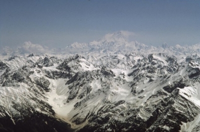
Covering an area of nearly six lakh sq.km., and spanning many regions, including India. Nepal, Bhutan, and Tibet, the Himalayas is one of the youngest mountain ranges in the world. Home to the world’s highest peak Mount Everest, it hosts several other high peaks too. Due to the different altitudes and climatic conditions within the vast expanse of the region, the vegetation is varied too. It spans everything from deciduous forests and alpine forests to meadows and scrubland. Many rivers and glaciers in the Himalayas too have a major influence in the shaping of the landscape.


Wildlife


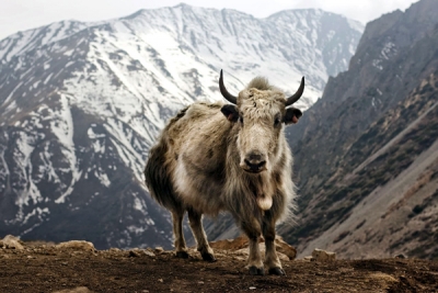
The diversity in the flora of the Himalayas also means it nurtures a wide variety of birds, animals, reptiles, and amphibians. Red panda, snow leopard, clouded leopard, Himalayan tahr, Himalayan black bear, Himalayan marmot, Himalayan yak, and langur, are among the animals that can be spotted in the region. Birds that can be found here include bulbuls, barbets, finches, kingfishers, flycatchers, buntings, cuckoos, thrushes, owls, pigeons, flowerpeckers, quails, woodpeckers, warblers, tits, larks and eagles. The Himalayan monal is one of the most colourful birds of the region.


Lifeline


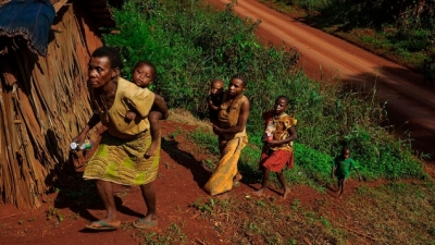
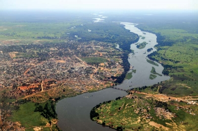
The Himalayas has been closely tied to the lives of people in Asia, and the mountain range is revered in several cultures. It is home to millions of people, and supports the livelihood of many more. Due to the altitude and location, the region plays an important role in the climate of many countries, including India. Several important rivers such as the Indus, the Ganges, and the Brahmaputra originate in the Himalayas. Melting snow, glaciers, and rainfall feed many of these perennial rivers, taking care of the water needs of millions of people across many countries. These rivers leave their nutrient-rich deposits as they flow, giving rise to fertile soil - just perfect for cultivation - across many regions. The forests of the mountain range not just host many types of wildlife but also ably support the growth of medicinal plants and timber, offer grazing grounds for cattle, in addition to several forest produce. The Himalayas is also an important place for tourists and pilgrims.


Threats


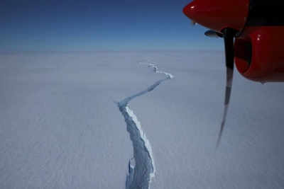
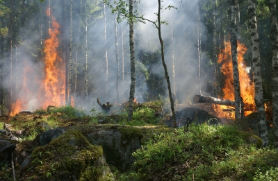
Climate change: Even though some of the areas in the Himalayas are remote, they are being affected by climate change too. Cold temperatures in most regions in the range have warmed up faster than in many parts of the world. As a result, glaciers and permafrost are melting faster. Even weather patterns have fluctuated wildly, triggering more natural disasters. This could mean dry spells, especially when farmers need water or unprecedented floods. These events affect landscapes, livelihoods, and lives too.


Human presence: While mountaineering can boost tourism in any country, it can bring with it several disadvantages too. Mount Everest in Nepal is a classic example of this. Already hit by climate change the peak is packed with mountaineers during the climbing season. Which means there's mounds of rubbish and garbage strewn around the place. Oxygen cylinders, cans, tom tents and ropes, and human waste make a bulk of the rubbish. Sadly, due to the expenses that could be incurred, sometimes the bodies of some dead climbers are left behind too. While there have been many calls to control the number of people climbing it and what they leave behind a lasting and concrete solution to the problem has remained elusive.


Territorial disputes: Since the mountain range spans many countries, "territorial disputes" can affect ongoing projects that study the region. Among these are international collaborations on research related to climate change in the mountain range. Diplomacy issues can last for a short period or extend into years, and both do affect precious work taken up to analyse the region.


Picture Credit : Google


How big is the iceberg that broke off Antarctica?


Did you know that a giant iceberg, more than twice the size of Mumbai, broke off from Antarctica's Brunt Ice Shelf late in February 2021? It wasn't entirely unexpected as scientists with the British Antarctic Survey (BAS) were expecting it for years.


How did it form?


The "North Rift crack, as it is called, is the third major chasm in the last decade to tear across the Brunt ice Shelf (an ice shelf is a large floating platform of ice that forms when a glacier flows down to a coastline and onto the ocean surface). After a major crack formed on the shelf in November 2020, it continued to grow until the iceberg broke off in dramatic fashion on February 26.


Even though such a breaking off is entirely normal and part of how the Antarctic ice shelves work, the North Rift is rather special owing to its size. This iceberg, in fact, has an estimated size of about 1,270 sq.km., more than twice the size of even a huge city like Mumbai (603.4 sq.km.).


Glacier vs iceberg


When large pieces of ice breaks off a glacier, ice calving, or iceberg or glacier calving, takes place. Thus, while glaciers are huge masses of ice that move slowly over landforms, an iceberg refers to the pieces of ice that have broken off either from glaciers or ice shelves and are now floating in open water.


According to a BAS statement, this ice split likely happened due to a natural process and there is no evidence suggesting that climate change had a role to play.


Glaciological structure of this vast floating ice shelf, however, is very complex and predicting the impact of such calving events is rather difficult.


Picture Credit : Google


How can forest fires be food for forests?


Forest fires cause such terrible destruction that it seems impossible they can do anything but harm to a forest. In forests that are carefully maintained by foresters this may be true. Foresters thin the trees regularly. They clear away dead wood and brushwood that might slow the growth of trees. And they plant saplings to grow into future trees. A forest fire in one of these managed forests can be disastrous.


Out in the wild, things are different. There nature has to manage the forest by itself. Under these circumstances fire can be a great help. A forest fire burns up dead wood and brush-wood to clear the ground for new growth. It has also been discovered that certain trees only release their seeds at very high temperatures. In fact, these trees need to heat of a forest fire before they drop their seeds to start new trees growing.


Picture Credit : Google


Why does the Leaning Tower of Pisa lean?


It was never intended to. That is why one of architecture’s big blunders is one of the world’s biggest tourist attractions. They both came about because of the tower’s foundations – or the lack of them. The tower is fifty-five metres tall but the foundations work began, the ground beneath started to give way. That was in 1173. The ground has been giving way slowly ever since. By the time building work finished, parts of the upper structure had been changed from the plans to counteract the leaning. That was in the late fourteenth century, and the changes must have helped. For over six hundred years Pisa’s famous landmark has been teetering on the brink of collapse. The reason it has not smashed to the ground is that it still has not passed its centre of gravity. Bits of masonry fall off now and then, and recently the tower has been closed to the public.


Now historians and engineers are scratching their heads wondering if they can stop the leaning and preserve the tower for another eight hundred years or more.


Picture Credit : Google


Where to find the world’s highest lake?


Of all the great lake that lie within the various continents the highest above sea level is Lake Titicaca which is situated in a vast, high plateau on the Andes between Peru and Bolivia. The lake is 3,811 metres above sea level which is about 1,000 metres lower than the summit of Mont Blanc. It has an area of 8,285 square kilometres and is divided into two by the Strait of Tiquina. The whole lake is 178 kilometres long and is very deep (370 metres). A number of narrow strips of land put out into the lake from the shore and from broad stretches of sheltered water where very tall reed forests grow. The local persons use these reeds to make boats. They also use the reeds to make big rafts which they load with soil and convert into floating gardens that produce beans, peppers, marrows, potatoes and other vegetables.


The entire region round Lake Titicaca is fairly well populated because the climate is mild and good for farming. The clear waters of the lake contain many kinds of fish.


Picture Credit : Google


Where arrowroot is produced?


Pharmaceutical companies specializing in the manufacture of baby foods import large quantities of a light but nutritious flour known as arrowroot. This flour is obtained from the Maranta arundinacea, a beautiful herbaceous plant originally from the tropical regions of America. Today the arrowroot plant is also grown in India and parts of Africa.


The nutritive parts of the Maranta are found in the large underground roots or rhizomes. These have a high starch content, as well as some protein and salts, and are prepared in different ways as food by the natives of the region.


The Maranta also has another fine feature; a magnificent clump of shiny leaves that makes the plant very ornamental. This clump of leaves is a common feature in all the plants of this family which includes some species.


Picture Credit : Google


Where to find the world’s highest capital city?


At the foot of the soaring peak of Mount Illampu (6,550 metres) and Mount Illimani (6,459 metres) on the Andes mountain range, stands, the city of La Paz, the capital of Bolivia, founded by the Spaniards in 1548.


Situated on a high plateau a little south of Lake Titicaca, this city of almost 900,000 inhabitants rises to a height of 3,831 metres, the highest capital city in the world. But it is not Bolivia’s highest city. Oruro for example, which has almost 140,000 inhabitants, is 3,715 metres above sea level. There are even higher inhabited places: the village of Chacaltaya, lost in the mountains of the Andes, is 5,130 metres above sea level which is higher than the summit of Mont Blanc.


At such altitudes the air is very thin and contains less oxygen, but the Indians can live and work in these conditions without suffering too much. For thousands of years they have been used to living at great altitudes and their bodies have become adapted to the severe climate of the Andes. As a result of breathing in the thin air they have developed large chests to extract as much oxygen as possible from the air.


Bolivia has no sea coast and its territory is almost completely covered by mountains. These include high mountain chains in the west and a number of high plateau, most of them arid and all of them about 4,000 metres above sea level. In the east the land slopes gently away downwards to the immense river basin of the Amazon.


Picture Credit : Google


Where to find the world’s highest railways?


In Peru the trains climb up the Andes Mountains to a height of 4,816 metres. This is the railway line that starts at Callao on the Pacific coast and goes to La Oroya: it is the highest railway line in the world.


The railway line from Rio Mulato to Potosi reaches a height of just over 4,787 metres, almost as high as Mont Blanc, Europe’s tallest mountain. The highest railway line in Europe is at the Jungfrau in Switzerland and reaches a height of just over 3,454 metres.


On these South American lines the trains set out at sea level and reach great heights so rapidly that nurses travel on them to help the passengers with oxygen masks if they feel ill as a result of the rapid change in air pressure and the thinness of the air. The railways across the Andes provide vital links between the lowland regions, but the cost of construction and maintenance is very great.


Picture Credit : Google


Where is the ‘Roof of the World’?


The highest mountain in the world in the Himalayas: it is Mount Everest. For hundreds of years nobody succeeded in reaching the summit. The people of Tibet called are Chomolungma, meaning ‘father of mountains’, and believed that strange wild creatures wandered about the mountain’s perpetual snows.


Many people thought it would be impossible to measure or climb Mount Everest. The British, who ruled India until after the Second World War, established an office in the 1800s to survey the mountain and measure it. The man who had the idea to start the office was George Everest and he also wanted to measure all the other mountains in the Himalayas. After much work the task was completed in 1852. The height was finally calculated as 8,840 metres (later established more precisely as 8,848 metres). The mountain was named after Everest in 1863. Another century passed before the peak of Everest was finally reached. In 1953 Edmund Hillary, a New Zealander, and Sherpa Tenzing, a skilled mountaineer of India, climbed to the summit. Hillary and Tenzing had to wear oxygen masks to help them breathe in the thin air. The two climbers planted the flags of Britain, Nepal, India and the United Nations on the peak on which man had never before set foot.


Picture Credit : Google


Where the pygmies live?


The broad band of dense forests that cover the equatorial zone of Africa are scattered here and there by clearings where small tribes of pygmies live. The pygmies are the smallest people in the world and are descended from an ancient race that once inhabited Africa. Today the pygmies live much as they have always done for thousands of years and still have very primitive conditions. They are afraid of the white man and try to remain isolated from the rest of the world. Occasionally they visit Bantu villages on the edge of the forests to the animals they have caught for tools and arrowheads.


Many scientists believe the pygmies are descended from an ancient human stock that was once widespread throughout Africa. Pygmies are now confined to the forests but there is proof that at one time they loved over a wider region. For example, Homer once described the terrifying battle between dwarf men and cranes, and Herodotus said the pygmies lived in the Libyan desert and were driven south by other invading peoples. Aristotle, too, referred to pygmies as inhabitants of the marshy regions round the source of the river Nile.


There were pygmies at the court of the pharaohs of Egypt where they proved to be skilful dancers and jugglers. Egyptian records show that 4,500 years ago pygmies were inhabiting some of the areas they still occupy today. Apart from these people who are now reduced to living in very difficult conditions in the forests.


Picture Credit : Google


From where do the Nile rises?


The nineteenth century was the age of great explorations of Africa when, one by one, the secrets of the Dark Continent were revealed. One of the mysteries that drove so many explorers to Africa was that which surrounded the source of the river Nile, probably the longest the river Nile, probably the longest river in the world, that flows for 6,690 kilometres through forests and deserts.


It was John Speke, a British explorer, who discovered the sources of the Nine. Speke was born in 1827 and served in the Indian army. He was thirsty when he made his great discovery.


Speke set out from Zanzibar accompanied by Richard Burton. The two men headed for central Africa by way of Lake Tanganyika. A few months later, in 1859, Speke arrived alone at a great lake which he named Victoria in honour of the British monarch. Speke had the feeling that the Nile began somewhere in the region. In 1862 he travelled along the west bank of Lake Victoria together with his fellow-countryman James Grant and discovered a river, the turbulent lake. For Speke there were no more doubts: from that river, named the Kageera, came the waters which first formed the lake and then the Nile. Speke telegraphed London that the source of the Nile had been found. He was right and the great mystery had been solved.


Picture Credit : Google