Two years after Indian independence, which city was replaced by Bhubaneswar as Odisha’s capital?


Bhubaneswar replaced Cuttack as the capital on 19 August 1949, 2 years after India gained its independence from Britain. 


Notably, the capital of the then British-ruled Orissa Province was Cuttack, which was vulnerabile to floods and suffered from space constraints. Thus on 30 September 1946, a proposal to move the capital to a new capital was introduced in the Legislative Assembly of the Orissa Province. After the Independence of India, the foundation of the new capital was laid by India’s first Prime Minister Jawaharlal Nehru on 13 April 1948.


Accordingly, Bhubaneswar replaced Cuttack as the capital on 19 August 1949, 2 years after India gained its independence from the British Raj.


The modern city, now with a smart city tag since 2016, was designed by the German architect Otto Königsberger in 1946. Along with Jamshedpur and Chandigarh, it was one of modern India’s first planned cities.


Bhubaneswar and Cuttack are often referred to ‘Twin Cities of Odisha’. The metropolitan area formed by the two cities had a population of 1.7 million in 2011.

Bhubaneswar is categorised as a Tier-2 city. An emerging information technology (IT) and education hub, Bhubaneswar is one of the country’s fastest-developing cities.


Picture Credit : Google


What is another name of Goa’s capital Panaji?


Panaji is the state capital of Goa. The city is also known as Panjim. Panaji with a population of 40,017 (2011 census), is the biggest city in north Goa, and the third biggest city in the state after Vasco da Gama and Margao. It is on the southern banks of the Mandovi River. However, the greater Panaji metropolitan area also has a beachfront location with the Arabian Sea. It is the peninsula of the Mandovi where you will see floating casinos and cruise boats. Panjim is 27.8 kilometers from the Goa International Airport at Dabolim.


According to census report of 2011 India, approximately 114,405 people reside in Panaji metro city. Among them the male person compromise a population of 59,379 and rest 55,026 are female. Maximum of them survive with the profession of fishing. Now a day’s tourism is another source of income by the inhabitants of Panaji. Usually, maximum citizen of Panaji use Konkani as primary spoken language. But, some other languages like Urdu, Marathi, Kannada, Hindi and English are also used by a marginal.


People of Panaji mainly belong to Hindu and Christian Religion. But, some other religions like, Muslim, Buddhist, Jains, Sikh, etc also live with marginal. Goans celebrate lots of fair and festivals throughout the year in the city. Most popular festival of Panaji is first day of New Year or Fontainhas celebration. Some other attractive festivals of the city are the Holi (festival of color), Narkasur parade before the festival Diwali, Bonderam, Festival, Christmas, Easter, Sao Joao Festival, Shigmotsav, St. Francis Day, Feast of Three Kings, Ganesh Chaturthi, Goa Carnival and Good Friday.


The main transportation hub is across the “Patto Bridge” over the Rua de Ourem creek at the Kadamba Bus Station. From this Bus station buses take off regularly to other Goan cities like Margao, Vasco da Gama, Mapusa , Ponda and other towns in Goa and to neighboring states. The nearest train station is Karmali, near Old Goa.


Typical of a Goan town, Panaji is built around a church facing a prominent square. The town has some beautiful Portuguese Baroque style buildings and enchanting old villas. The riverside, speckled with brightly whitewashed houses with wrought iron balconies, offers a fine view.


Picture Credit : Google


Which South Indian Union Territory and its capital share the same name?


Puducherry, original name Putucceri, formerly (until 2006) Pondicherry, also spelled Pondichéry, union territory of India. It was formed in 1962 out of the four former colonies of French India: Pondicherry (now Puducherry) and Karaikal along India’s southeastern Coromandel Coast, surrounded by Tamil Nadu state; Yanam, farther north along the eastern coast in the delta region of the Godavari River, surrounded by Andhra Pradesh state; and Mahe, lying on the western Malabar Coast, surrounded by Kerala state. The territory’s capital is the city of Puducherry in the Puducherry sector, just north of Cuddalore.


The original name of the territory, Putucceri, is derived from the Tamil words putu (“new”) and ceri (“village”). The French corrupted this to Pondichéry (English: Pondicherry), by which it was called until its name was officially changed to Puducherry in 2006. Area 190 square miles (492 square km). Pop. (2011) 1,244,464.


The Union Territory of Puducherry consists of four small unconnected districts: Puducherry district (293 km2 or 113 sq mi), Karaikal district (161 km2 or 62 sq mi) and Yanam district (20 km2 or 7.7 sq mi) on the Bay of Bengal and Mahé district (9 km2 or 3.5 sq mi) on the Laccadive Sea, covering a total area of 483 km2 (186 sq mi). Puducherry and Karaikal have the largest areas and population, and are both enclaves of Tamil Nadu. Yanam and Mahé are enclaves of Andhra Pradesh and Kerala respectively. Its population, as per the 2011 Census, is 1,244,464.


Some of Puducherry's regions are themselves amalgamations of non-contiguous enclaves, often called "pockets" in India. The Puducherry region is made of 11 such pockets, some of which are very small and entirely surrounded by the territory of Tamil Nadu. Mahé region is made up of three pockets. This unusual geography is a legacy of the colonial period with Puducherry retaining the borders of former French India.


All four regions of Puducherry are located in the coastal region. Five rivers in Puducherry district, seven in Karaikal district, two in Mahé district and one in Yanam district drain into the sea, but none originates within the territory.


Picture Credit : Google


Which Union Territory’s capital is Silvassa?


Dadra and Nagar Haveli is a district of the Indian union territory of Dadra and Nagar Haveli and Daman and Diu in western India. It is composed of two separate geographical entities: Nagar Haveli, wedged between Maharashtra and Gujarat and 1 km to the northwest, the smaller enclave of Dadra, which is surrounded by Gujarat. Silvassa is the administrative headquarters of Dadra and Nagar Haveli.


The climate is typical of the region. Summers are hot, with the mean temperatures in May typically rising into the low 90s F (mid-30s C). Annual rainfall averages about 120 inches (3,050 mm), most of it falling between June and September.


Farming is the chief occupation and is largely practiced by the indigenous people, most of whom live in rural areas. Much cultivation is done on terraced land. Rice and ragi (also called finger millet) are the major food crops. Wheat and sugarcane are also grown. A dam and reservoir on the Daman Ganga River in neighbouring Gujarat has extended irrigation in the territory significantly. Timber production is mainly centred on the valuable native teak.


Dadra and Nagar Haveli came under the rule of Portugal in the late 18th century. The Marathas ceded Nagar Haveli to the Portuguese in 1783 as compensation for a Portuguese vessel that their navy had destroyed. Two years later Portugal acquired Dadra, which became a kind of fief. After India achieved independence in 1947, nationalists in Goa—the oldest Portuguese possession in India—sought to break away from Portugal; their first successes were the seizure of Dadra on the night of July 21, 1954, and their capture of Nagar Haveli two weeks later. A pro-Indian administration was formed in these enclaves, and on June 1, 1961, Dadra and Nagar Haveli requested accession to the Indian union. Although the Indian government had already acknowledged the incorporation of the two areas after their liberation from the Portuguese, their status as a single union territory was made official on Aug. 11, 1961.


Picture Credit : Google


Which is the capital of Maharashtra’s winter?


Nagpur is the winter capital of the state of Maharashtra, a fast growing metropolis and third largest city in Maharashtra after Mumbai and Pune. With a population of 46,53,570 (2011) Nagpur Metropolitan Area is the 13th largest urban conglomeration in India. It has also recently been ranked as the cleanest city and the second greenest city of India . In addition to being the seat of annual winter session of Maharashtra state assembly “Vidhan Sabha”, Nagpur is also a major commercial and political center of the Vidarbha region of Maharashtra, and is also famous throughout the country as “Orange City” for being a major trade center of oranges that are cultivated in the region. In addition, the city also derives political importance from being the headquarters for the RSS and an important location for the Buddhist movement.


Nagpur is the seat of the annual winter session of the Maharashtra state assembly. It is a major commercial and political centre of the Vidarbha region of Maharashtra. In addition, the city derives unique importance from being an important location for the Dalit Buddhist movement and the headquarters for the Hindu nationalist organisation RSS. Nagpur is also known for the Deekshabhoomi, which is graded an A-class tourism and pilgrimage site, the largest hollow stupa among all the Buddhist stupas in the world.


It is famous for Nagpur oranges and is sometimes known as the Orange City for being a major trade center of oranges cultivated in large part of the region. It is also called the Tiger Capital of India or the Tiger Gateway of India as many tiger reserves are located in and around the city and also hosts the regional office of National Tiger Conservation Authority. The city was founded in 1703 by the Gond King Bakht Buland Shah of Deogarh and later became a part of the Maratha Empire under the royal Bhonsale dynasty. The British East India Company took over Nagpur in the 19th century and made it the capital of the Central Provinces and Berar. After the first re-organisation of states, the city lost its status as the capital. Following the informal Nagpur Pact between political leaders, it was made the second capital of Maharashtra.


Picture Credit : Google


Tripura’s capital Agartala is located very close to the border of which neighbouring country?


Tripura, state of India, It is located in the northeastern part of the subcontinent. It is bordered to the north, west, and south by Bangladesh, to the east by the state of Mizoram, and to the northeast by the state of Assam. 


Agartala offers some outstandingly beautiful palaces, gardens, hills, temples and lakes. Perfection is the word for the architectural monuments of the city. The red government buildings are in contrast against the remarkably usually white old British buildings that are still in existence and in use. Some of the monuments have been selected as UNESCO world heritage sites.


It was Maharaja Krishna Chandra Manikya Bahadur, of Manikya Dynasty, who shifted the capital of Swadhin Tripura to Agartala in the 19th century. The earlier capital was Rangamati in south Tripura. It was shifted to old Agartala which was called ‘Haveli’. However, frequent invasions by Kuki’s and also to maintain communication with British Bengal, the Maharaja shifted his capital from Old Haveli to New Haveli (present Agartala) in 1849. During the British Raj, Agartala was the capital of the former ‘Hill Tippera’ state.


During the reign of Maharaja Bir Chandra Manikya (1862), Agartala Municipality was formed. In the 1940s the town was planned and re-constructed properly with new roads, markets and buildings.


Picture Credit : Google


Which city is capital of Chhattisgarh?


Chhattisgarh, state of east-central India. It is bounded by the Indian states of Uttar Pradesh and Jharkhand to the north and northeast, Odisha (Orissa) to the east, Telangana (formerly part of Andhra Pradesh) to the south, and Maharashtra and Madhya Pradesh to the west. Its capital is Raipur. Area 52,199 square miles (135,194 square km).


Naya Raipur would be India's fourth planned city after Chandigarh, Ahmedabad, and Bhubaneswar and has been constructed in phases incorporating world class architecture and design. Naya Raipur is also planning as the business, cultural and educational hubs of the Indian state Chhattisgarh. Greater Raipur is an urban agglomeration comprising the city of Raipur along with the new city of Naya Raipur and the industrial city of Bhilai-Durg. Raipur was a city of Indian state Madhya Pradesh, before Chhattisgarh was formed on 1st November 2000.


Raipur also serves as the administrative headquarter of Raipur District. Raipur District is bordered by Bilaspur by the North, Bastar & Orissa by the South, Raigarh & Orissa by the East and the Durg to the West. The district is divided into two major divisions, namely, the Chhattisgarh plain and the Hilly Areas. Raipur City is situated at the center of Raipur District. It covers an area of 180 sq. km. and it maintains a height of 298.16 meters above mean sea level. According to the census report 2011, the city has a population of 1,010,087. As on 2016, Raipur is the 45th largest populous metropolis in India with an approximate population of 1,456,406.


Once, Raipur was a part of the Dakshina Kosala Kingdom, later it was a part of the Maurya Kingdom and the capital of the Haihaya kings who controlling the traditional forts of the Chhattisgarh for a long time. The town of Raipur has been in existence since the 9th century. Archaeological evidence and ruins of the fort can be seen in the southern part of Raipur city, which have historically important in the ancient Indian History.


Picture Credit : Google


Which State’s capital was earlier called Madras?


Chennai, formerly Madras, city, capital of Tamil Nadu state, southern India, on the Coromandel Coast of the Bay of Bengal. At the time of its formation in 1950, it included the whole of present-day Tamil Nadu (except Kanyakumari district), Coastal Andhra, Rayalaseema, the Malabar region of North and central Kerala, and Bellary, South Canara. Coastal Andhra and Rayalaseema were separated to form Andhra State in 1953, while South Canara and Bellary districts were merged with Mysore State, and Malabar District with the State of Travancore-Cochin to form Kerala in 1956. Post State Reorganization in 1956, the remaining Madras State was renamed to Tamil Nadu, meaning "Tamil country" on January 14, 1969.


After Indian Independence, the Madras Presidency became the Madras Province on 15 August 1947. On 26 January 1950, it was formed as Madras State by the Government of India. As a result of the 1956 States Reorganisation Act, the state's boundaries were re-organized following linguistic lines. The state was finally renamed Tamil Nadu on 14 January 1969 by C.N.Annadurai, Chief Minister.


Over the years, it became a matter of linguistic pride to reclaim the names of cities in the vernacular rather than hang on to the names previous colonial administrators left cities with. These were looked at as an unwanted legacy of colonial rule.


The new name Chennai was derived from the name Chennaipattanam, a town near Fort St. George which the British built in 1639. There are two theories about the name Chennaipattanam. According to the first, the name Chennaipattanam was taken from the name of the Telegu king Damarla Chennappa Nayakudu Nayaka, from whose father they acquired the town in 1639. The second theory is that Chennai is named after the Chenna Kesava Perumal Temple, since the word Chennai means face in Tamil, the temple is considered to be the face of the city.


Picture Credit : Google


In 2017, which city was announced as Himachal Pradesh’s second capital?


On 19 January 2017, Chief Minister Virbhadra Singh declared Dharamshala as the second capital of Himachal Pradesh state, making Himachal Pradesh the third state of India with two capitals after Jammu and Kashmir and Maharashtra.


Dharamshala is a municipal corporation city in the upper reaches of the Kangra Valley and is surrounded by dense coniferous forest consisting mainly of stately Deodar cedar trees.The suburbs include McLeod Ganj, Bhagsunag, Dharamkot, Naddi, Forsyth Ganj, Kotwali Bazar (the main market), Kaccheri Adda (government offices such as the court, police, post, etc.), Dari, Ramnagar, Sidhpur, and Sidhbari (where the Karmapa is based). This place is also famous for its Himachal Pradesh Cricket Association Stadium (2003), which offers opportunities to the youth of state to prepare for their future in the game. The McLeod Ganj town, lying in the upper reaches, is known worldwide for the presence of the Dalai Lama. On 29 April 1959, the 14th Dalai Lama (Tenzin Gyatso) established the Tibetan exile administration in the north Indian hill station of Mussoorie. In May 1960, the Central Tibetan Administration (CTA) was moved to Dharamshala, making it the centre of the Tibetan exile world in India. Following the 1959 Tibetan uprising there was an influx of Tibetan refugees who followed the 14th Dalai Lama. His presence and the Tibetan population have made Dharamshala a destination for Indian and foreign tourists, including students studying Tibet.


Picture Credit : Google


What was the ancient name for Bihar’s capital Patna?


One of the oldest continuously inhabited places in the world, Patna was founded in 490 BCE by the king of Magadha. Ancient Patna, known as Patliputra or Pataliputra, was the capital of the Magadh Empire through Haryanka, Nanda, Mauryan, Shunga, Gupta and Pala dynasties.


Patliputra really saw its pinnacle during the Maurya period when it became one of the largest cities in the world. As per the Greek diplomat, traveller and historian Megasthenes, during the Mauryan Empire, it was among the first cities in the world to have a highly efficient form of local self-government.


Extensive archaeological excavations have been made in the vicinity of modern Patna. Excavations early in the 20th century around Patna revealed clear evidence of large fortification walls, including reinforcing wooden trusses. Now we know that after the post-Palas decline, it was Sher Shah Suri (1538–1545) who revived Pataliputra and renamed it Pa?na.


The first accepted references to the place are observed more than 2500 years ago in Jain and Buddhist scriptures. Recorded history of the city begins in the year 490 BCE when Ajatashatru, the king of Magadh, wanted to shift his capital from the hilly Rajgriha to a more strategically located place to combat the Licchavi of Vaishali. He chose a site on the bank of the Ganges and fortified the area which developed into Patna.


From that time, the city has had a continuous history, a record claimed by few cities in the world. During its history and existence of more than two millennia, Patna has been known by different names: Pataligram, Pataliputra, Palibothra, Kusumpur, Pushpapura, Azimabad, and the present-day Patna. Gautam Buddha passed through this place in the last year of his life, and he had prophesied a great future for this place, but at the same time, he predicted its ruin from flood, fire, and feud.


Picture Credit : Google


Why is China’s new dam a cause for concern?


What is the course of the river Brahmaputra?


The Brahmaputra (called Yarlung Tsangpo in China) is one of the longest rivers in the world. Starting in the Himalayas in Tibet it enters India in Arunachal Pradesh, then passes through Assam, Bangladesh, and empties into the Bay of Bengal. The Brahmaputra, a perennial river, is the lifeline for communities living along its banks. They use it for irrigation, fisheries and inland water transport, In its lower course, the river is both an advantage and a disadvantage. On the one hand, it deposits huge quantities of fertile alluvial soil suitable for agriculture, but on the other, due to geographical and climatic conditions, it causes periodical disastrous floods in Assam and Bangladesh.


Where is China planning to build the dam?


The dam is to be built on the river in Medog county, where it drops by 2,000 metres, making it an ideal place to harness hydropower. This region is located in the Tibet Autonomous Region, governed by China.


Why is China building it?


The proposal to build a dam on Yarlung Tsangpo featured in China's 14th Five Year Plan announced in 2020. According to the Chinese officials, the hydroelectric project in the Medog county is part of the country's renewable energy generation initiatives and that it will help China achieve carbon neutrality by 2060 and also pave way for development in the Tibet Autonomous Region.


In 2010, China began construction of small dams along the mainstream of the Yarlung Tsangpo, two of them have already been completed and at least three are under construction, according to reports. The proposed one is the largest of them all.


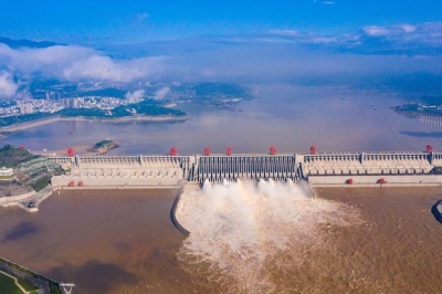
How big is this project?


The new dam could help generate up to 60 gigawatts of power three times that of central China's Three Gorges Dam, which has the largest installed hydropower capacity in the world now. The new dam could provide 300 billion kWh of dean, renewable and zero carbon electricity annually. The power generated would help Beijing meet its clean energy goals and strengthen water security, according to Yan Zhiyong, chairman of the Power Construction Corporation of China.


What will be its impact on India?


Agriculture


Such a huge dam could hold back massive amount of silt carried by the river (silty soil is more fertile than other types of soil and it is good for growing crops.) This could affect farming in the areas downstream.


Water resources


The construction of dams upstream will have a significant effect on areas downstream. China has claimed that it is building a run of the river hydropower project, which do not involve storage or diversion of the waters of the Brahmaputra (Run of the river hydroelectric systems are hydroelectric systems that harvest the energy from flowing water to generate electricity). However, experts say it could still reduce water flow downstream, especially during the dry season.


India is also worried about the release of water during the monsoons, when northeastern states such as Assam experience floods. If China released water from the dam, it could be disastrous for an already inundated Assam.


Water as a weapon?


Being an upstream area, China has a dear advantage in building dams and other infrastructure to store or divert the flow of the river system


There is the potential to significantly change the flow rate during times of standoff between the countries. India has agreements with China that require the latter to share hydrological data of the river during monsoon season between May and October. The data is mainly of the water level of the river to alert downstream areas in the event of floods. However, during the 2017 Doklam border standoff between India and China, China stopped communication of water flow levels from its dams. Though data sharing resumed in 2018, India has reasons to believe that China may withhold data.


Seismological impact


The Himalayan region is vulnerable to earthquakes and other seismic activities. The sheer size of the infrastructure projects undertaken there poses a significant threat to the populations living downstream


Ecological impact


Several species of flora and fauna are endemic to this part of the world and some of them are critically endangered. The ecosystem in the Himalayan region is already on the decline. The glaciers have been retreating due to climate change. Deforestation soil erosion and landslides are some of the other issues here. The combined dam plans of China and India (See net question) could have disastrous consequences in this ecologically sensitive zone.


What is India's response?


India has urged China to ensure that the interests of downstream states are not harmed by any activity in upstream areas. Meanwhile, India is considering building a 10 gigawatts (GW) hydropower project in the Dibang valley in Arunachal Pradesh, to mitigate the adverse impact of the Chinese dam.


Picture Credit : Google