How much freshwater do we have?


There's a good reason our planet is called "the water planet- nearly two-thirds of it is covered in water. To quantify it further, that's more than 300 million cubic miles of water. That's quite adequate for humans, isn't it? Well, not really. Because, 97% of it is in the oceans - salty, undrinkable and not usable for cooking or raising crops. Oh, so we have just 3%? Well, not even that much. Because about 2.5% of that is trapped in glaciers, ice caps, the atmosphere, and soil or is inaccessible because it lies very deep under the Earth's surface. So that leaves us - over seven billion humans (and wildlife!) - with less than 0.5%. Do you know how little that is? A report says that if all the water in the world can be equated to 100 litres, then all the freshwater we have access to is about half-a-teaspoon! Our drinking and cooking water sources are groundwater, freshwater lakes, rivers, etc Though water can be seen as a renewable resource, the demand for freshwater has been slowly outdoing how much is replenished naturally, especially through the likes of rain. This is indicative not just of imbalance and a changing planet but also of potential global health and political crisis. That wars could be fought over water may not be a problem of a distant future. Which is why there has been consistent and loud calls for water conservation and recycling universally. The impact of water shortage has been showing, and when the problem becomes even more acute it will affect not just humans but also the plants and animals in it and most importantly, our planet itself as a whole.


Picture Credit : Google


Why is Bengali not in the list of classical languages of India?


At present there are 6 languages which are marked as classical language in India.


  • Tamil (declared in 2004)

  • Sanskrit (2005)

  • Kannada (2008)

  • Telugu (2008)

  • Malayalam (2013)

  • Oriya (or Odia) (2014)


The reason why Bengali is not in this list is - Bengali has been derived from Magadhi-Apabhransha which is again derived from Sansrit-Prakrit. Unlike the classic languages which predates bengali and are more of a direct language.


According to information provided by the Ministry of Culture in the Rajya Sabha in February 2014, the guidelines for declaring a language as ‘Classical’ are:


“(i) High antiquity of its early texts/recorded history over a period of 1500-2000 years;


(ii) A body of ancient literature/texts, which is considered a valuable heritage by generations of speakers;


(iii) The literary tradition be original and not borrowed from another speech community;


(iv) The classical language and literature being distinct from modern, there may also be a discontinuity between the classical language and its later forms or its offshoots.”


Bengali does not satisfy all the criteria mentioned above.


Credit : Quora


Picture Credit : Google


Do airliners fly over the Himalayas?


Not only the Himalayas but planes don't fly directly over the Pacific ocean too. They instead choose alternative paths for flying even if they have to cover a longer distance.(ie. flight paths are curved towards the pole instead of a straight line across the Pacific).


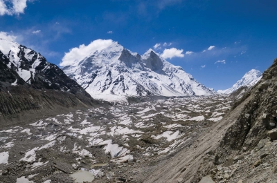
So first and the foremost reason is the height of Himalayas.


If we talk about the Himalayas, all the peaks of Himalayas is more than 20,000 feet high which are not suitable for the commercial airplanes to fly as they fly over 30,000 feet to avoid all weather related disturbances whose centre is stratosphere. In stratosphere no weather related disturbances occur and it’s the most suitable for the airplanes to fly.


There are also other important reasons :-


No scope for emergency landing.


They avoid flying over the Pacific Ocean and opt for curved routes because the curved routes are safer as airlines then fly over the land than the ocean. Therefore they spend less time over the ocean, allowing for emergency landings. Emergency landing is done on a flat land. Moreover the Himalayan regions are also not safe for emergency landings as the region has no flat surfaces. Additionally the risk factor also increases as there are mountains everywhere.


2. All weather related events occur in troposphere and the height of troposphere ranges upto 20 km from lithosphere. In troposphere the weather is not suitable for the airplanes to fly because changing weather patterns have a negative impact on the flight of airplanes and there are chances of occurrence of unfortunate events.


3.Another important reason why commercial airplanes don’t fly over the Himalayas is that the Indian Air Force and the People’s Liberation Army Air Force conduct training sessions in the region. They restrict commercial airlines from flying above them.


4. There is also a risk of oxygen running out in these areas as airlines usually have only 20 min of emergency oxygen. So in a situation where the supply runs out, the flight must descend to at least 10,000 feet to replenish oxygen, which is known as Drift Down Procedure. But in Himalayas, descending to 10,000 feet is suicide.


5. They have to overcome the weather related disturbances and there is also scarcity of oxygen. Additionally on the peaks of the Himalayas, air turbulence is also abnormal which affects the speed of airplanes and even the passengers may face discomfort due to the scarcity of oxygen.


6. The Himalayan region is scarcely populated due to which Navigation Radar Service can be barely found and the pilots face difficulties in establishing a connection with the ground and in case of any emergency the pilot will not be able to seek any help due to poor Navigation Radar Service. So the pilots find it better to opt for alternative instead of flying over the Himalayas and the Pacific Ocean.


7. And this one is interesting :(Flat maps)


The main reason flight don’t go over the Pacific Ocean is because curved routes are shorter than straight routes.


Flat maps are confusing as the earth itself isn’t flat.


As a result the straight routes don’t offer the shortest distance. You can verify this by conducting a small experiment using a globe. Identify two locations such as the US and the Middle Asia, and then connect a piece of string directly between these two areas to mimic a straight route. Use a marker to highlight the distance . Then similarly measure a curved path. Assuming that you followed the above mentioned steps correctly, you will discover that the curved route is physically shorter than the straight route.


If you are still not convinced here is another logical reason :


Airplanes follow a geodesic curve while flying. Geodesic means the shortest distance between the points in terms of constant velocity. If there is an airport where you have to reach and the airplane hops at one airport on the way, then there is also an airport nearby with the same distance from your destination. All airplane routes are planned based on this geodesic curve but the Himalayan region and the Pacific Ocean region lacks airports.


So now you must be having a clear idea that it is not a mystery that airplanes do not fly over the Himalayas and the Pacific Ocean but it is the scientific reasons which make it impossible and doesn’t allow airplanes to fly over the Himalayan and the Pacific region.


Credit : Quora


Picture Credit : Google


What is the oldest undisturbed, untouched forest in the world?


Mount Lico, a mountain in Northern Mozambique, Africa, stands at approximately 1,100 meters with up to 700 meters of sheer rock walls, making it difficult for humans to climb; who aspires to climb a 1,100 meter mountain anyway, when you can climb higher mountains at more relative ease?


Mount Lico supports an old-growth rainforest atop its peak:


It’s not exactly untouched: in 2018 a team of researchers and expert mountaineers visited the forest (detected for scientific reasons by Google Earth) for exploration*. They encountered small animals that may or not be known to science thus far (including a new species of butterfly). Curiously, they also noticed mysterious clay pots placed near a mountaintop stream that they assume were left there for ceremonial reasons. The most conclusive perception of the forest, given all news reports, is that the forest has been largely untouched, un-accessed and thankfully undisturbed for a very long time.


Credit : Quora


Picture Credit : Google


What are some interesting facts about different country flags?


Here are some interesting facts about the flags of different nations of the world :


1. The flag of Niger is very similar to that of India. The only difference is, there is an Ashok Chakra in the Indian flag and the flag of Niger contains an orange circle.


2. The Flags of the Republic of Ireland and Ivory Coast are identical tricolours except for the order of the colours is reversed.


3. Saudi Arabia’s flag is manufactured with reverse sides. The sword points to the left, in the direction of the script.


4. The Afghan and Cambodian Flags hold the distinction of being the only two flags in the world to feature a building in their design.


5. The Flag of the Czech Republic was identical to the Flag of Poland, so a blue triangle was added at the hoist to the Czech flag.


6. The current flag of the United States was designed by 17-year-old Robert Heft, as part of a school project. He received a grade of B-.


7. The flags of Monaco & Indonesia are identical except in dimension (the flag of Monaco is narrower).


8. The flags of Romania & Chad differ only in the shade of blue they use.


9. The flag of Libya from 1977 to 2011 was the only plain flag in the world.


10. Nepal is the only country with a non-quadrilateral flag.


11. The Flag of Pakistan has set the World Record 3 times. On 15 February 2014, 29040 people gathered in a stadium in Lahore to form the world’s largest flag comprising of humans, which was certified by Guinness World Records.


Credit : Google


Picture Credit : Google


Which river flows in the Mudumalai Tiger Reserve?


The Moyar river flows downstream into the Mudumalai Tiger Reserve and is the natural line of division between Mudumalai and Bandipur Sanctuary.


The Western Ghats Nilgiri Sub-Cluster of 6,000 Km2, including all of Mudumalai National Park, is under consideration by the UNESCO World Heritage Committee for selection as a World Heritage Site.


A variety of habitats ranging from Tropical Evergreen forest, Moist mixed deciduous, Moist Teak forest, Dry teak forest, Secondary grass lands, Shrubs and Swamps exists here.


There is a high diversity of animal life in the park with about 50 species of fishes, 21 species of amphibians, 34 species of reptiles, 200 species of birds and 50 species of mammals.


The park is ideal home to several endangered and vulnerable species including Elephant, Tiger, Gaur, Leopard, Deer, Wild dog etc.  There are about 200 species of birds in the park, including White rumped vulture, Long billed vulture, Red crest, Mynas, Parakeets, Owls etc.


Mudumalai National Park is located in the Nilgiris district of the state of Tamil Nadu. Mudumalai National Park is a part of Mudumalai Wildlife Sanctuary.


Mudumalai National Park is situated at the tri-junction of the three southern states of Tamilnadu, Kerala, and Karnataka.


The Sanctuary shares its boundaries with the states of Karnataka and Kerala.


Picture Credit : Google


Which river flows into neighbouring Tamil Nadu before draining into the sea at Poompuhar?


Cauvery water enters Tamil Nadu from Karnataka at Dabhakuzhi near Biligundulu in Dharmapuri district and the river endures rampant pollution from Mettur till the time it enters the sea in Poompuhar.


Cauvery is pumped from a place 100 km away from Bengaluru, making it Asia’s costliest water. The city receives about 1,390 million litres per day (MLD) water, and sewage of an equal amount or more is generated. The Bangalore Water Supply and Sewerage Board has 24 sewage treatment plants capable of treating only about 760 MLD. Remaining sewage flows directly into the lakes.


auvery’s tributaries, Noyyal and Bhavani, carry a considerable amount of pollution. The Noyyal is as good as dead due to effluents released by more than 700 dyeing units in Tiruppur. From Karur to Tiruchirapalli, the river flows at its broadest and is called Akanda Cauvery. Here, the river is put to severe stress due to rampant sand mining, which goes unabated till date despite numerous strictures by the Madras High Court.


Though the polluted water undergoes some natural cleaning process by the time it reaches the Delta region, letting of sewage and dumping of garbage and hospital waste into the river pollute it further, making the water unfit for drinking and sometimes even for irrigation.


Activists allege that the industries in the Cauvery belt release untreated effluents into the river during the night to escape the wrath of local people. The paper mill owned by the Tamil Nadu government near Karur is also a major cause for 

water pollution in the area and activists allege the factories on the banks of the river consume more water than they are allowed to pump.


Picture Credit : Google


In which state does the Rushikulya River flow?


The Rushikulya River is one of the major rivers in the state of Odisha and covers entire catchment area in the districts of Kandhamal and Ganjam of Odisha. The river flows from the Daringbadi hill station in Kandhamal district. In the Ganjam district it flows through Surada, Dharakote, Asika, Pitala, Purusottampur, Taratarini, Pratappur, Alladigam, Brahmapur, Ganjam and the Chhatrapur block. The river is 165 km long with a total catchment area of 7700 km2.


A number of large scale industries have been set up in the basin. Among them are Grasim Industries Ltd-Ganjam Chemical Division (formerly Jayashree Chemical Ltd). Aska Co-operative Sugar Industries Ltd. Nuagam, Aska Spinning Mills, Monorama Chemical Works Ltd., Orissa Tubes Pvt. Ltd., etc. There are about 3360 numbers of small scale industries of different categories mainly food and allied, forest & wood based, rubber and plastic products and glass and ceramics. There is enough scope for setting up forest based industries. The basin is rich in mineral wealth. The major economic minerals are clay, limestone, manganese, sand talc, black sand and grinding materials.


Picture Credit : Google


From which country does the Himalayan River Manas flow into India?


The river flows through Bhutan in a south-west direction between two ranges of the Lower Himalayas in V-shaped gorges and enters into Assam in India into the south-central foot hills of the Himalayas.


The river valley has two major reserve forest areas, namely the Royal Manas National Park (43,854 hectares (108,370 acres), established in 1966) in Bhutan and the contiguous Manas Wildlife Sanctuary (391,000 hectares (970,000 acres) in 1955 increased to 95,000 hectares (230,000 acres) in December 1985) encompassing Project Tiger reserve, an elephant reserve and a biosphere reserve, which constitutes a UNESCO World Heritage Site declared in December 1985.


The Manas River drains 41,350 square kilometres (15,970 sq mi) of eastern Bhutan and northeast India. It has three major branches: the Drangme Chhu, Mangde Chhu, and Bumthang Chhu that cover most of eastern Bhutan, with the Tongsa and Bumthang valleys also forming part of its catchment. The area drained in Bhutan territory is 18,300 km2 and is bound by the geographical coordinates 26.217°N 90.633°E. A part of the main stem of the river rises in the southern Tibet before entering into India at Bumla pass at the northwestern corner of Arunachal Pradesh.


Out of the large catchment of the river valley, protected or reserved areas have been specifically demarcated, both in Bhutan and India, which are declared national parks or sanctuaries. The two reserved forest and wild life areas cover an area of 9,938.54 square kilometres (3,837.29 sq mi), which account for about 24% of the total catchment area of 41,350 square kilometres (15,970 sq mi) of the Manas river valley; brief details are provided.


Picture Credit : Google


Which river is largely referred to as Tsangpo throughout its upper case?


The Brahmaputra called Yarlung Tsangpo in Tibet, Siang/Dihang River, in Arunachal Pradesh and Luit, Dilao in Assam, is a trans-boundary river which flows through Tibet, India and Bangladesh. It is the ninth largest river in the world by discharge, and the 15th longest.


The BrahmaputraRiver originates in the Chemayungdung mountain ranges which nearly sixty miles south-east of Mansarovar lake in the MountKailash range in Southern Tibet at an elevation of 5300 m.A spring called Tamchok Khambab spills from the glaciers which later gather breath and volume to become the Tsangpo, the highest river in world.


Apart from the name Tsangpo, the Brahmaputra is also known by its Chinese name, Yarlung Zangbo in Tibet.  There are several tributaries of Tsangpo in Tibet. Before entering India, the river passes Pi (Pe) in Tibet and suddenly turns to the north and northeast and cuts a course through a succession of great narrow gorges between the mountain Gyala Peri and Namjabarwa (Namcha Barwa) in a series of rapids and cascades.


In India the total basin area of BrahmaputraRiver is 197 316 sq. km. which 5.9% of the total geographic area of the country. In India the river is spread over states of Arunachal Pradesh, Assam, West Bengal, Meghalaya, Nagaland and Sikkim.


Picture Credit : Google


The Harappan civilization flourished around which river valley?


The Harappan civilization was located in the Indus River valley. Its two large cities, Harappa and Mohenjo-daro, were located in present-day Pakistan’s Punjab and Sindh provinces, respectively. Its extent reached as far south as the Gulf of Khambhat and as far east as the Yamuna (Jumna) River.


Before the excavation of these Harappan cities, scholars thought that Indian civilization had begun in the Ganges valley as Aryan immigrants from Persia and central Asia populated the region around 1250 BCE. The discovery of ancient Harappan cities unsettled that conception and moved the timeline back another 1500 years,situating the Indus Valley Civilization in an entirely different environmental context.


The Indus River Valley Civilization is considered a Bronze Age society; inhabitants of the ancient Indus River Valley developed new techniques in metallurgy—the science of working with copper, bronze, lead, and tin. Harappans also performed intricate handicraft using products made of the semi-precious gemstone Carnelian.


Picture Credit : Google


On which river bank is the Taj Mahal situated?


 The Taj Mahal was built on the banks of the river Yamuna, between 1631 and 1643, by the Mughal emperor Shah Jahan as a mausoleum for his beloved wife Arjumand Banu Begum, who was also known by the title Mumtaz Mahal. 


The Taj Mahal was designated as a UNESCO World Heritage Site in 1983 for being "the jewel of Muslim art in India and one of the universally admired masterpieces of the world's heritage". It is regarded by many as the best example of Mughal architecture and a symbol of India's rich history. The Taj Mahal attracts 7–8 million visitors a year and in 2007, it was declared a winner of the New 7 Wonders of the World (2000–2007) initiative.


The Taj Mahal incorporates and expands on design traditions of Persian and earlier Mughal architecture. Specific inspiration came from successful Timurid and Mughal buildings including the Gur-e Amir (the tomb of Timur, progenitor of the Mughal dynasty, in Samarkand), Humayun's Tomb which inspired the Charbagh gardens and hasht-behesht (architecture) plan of the site, Itmad-Ud-Daulah's Tomb (sometimes called the Baby Taj), and Shah Jahan's own Jama Masjid in Delhi. While earlier Mughal buildings were primarily constructed of red sandstone, Shah Jahan promoted the use of white marble inlaid with semi-precious stones. Buildings under his patronage reached new levels of refinement.


Picture Credit : Google


Which is the last Indian State the Himalayan River Ganges enters before flowing into Bangladesh and eventually into the Bay of Bengal?


 West Bengal is the last Indian state that the Ganges enters, and, after it flows into Bangladesh, the Mahananda River joins it from the north. In West Bengal in India, as well as in Bangladesh, the Ganges is locally called the Padma. The westernmost distributaries of the delta are the Bhagirathi and the Hugli (Hooghly) rivers, on the east bank of which stands the huge metropolis of Kolkata (Calcutta). The Hugli itself is joined by two tributaries flowing in from the west, the Damodar and the Rupnarayan. As the Ganges passes from West Bengal into Bangladesh, a number of distributaries branch off to the south into the river’s vast delta. In Bangladesh the Ganges is joined by the mighty Brahmaputra (which is called the Jamuna in Bangladesh) near Goalundo Ghat. The combined stream, there called the Padma, joins with the Meghna River above Chandpur. The waters then flow through the delta region to the Bay of Bengal via innumerable channels, the largest of which is known as the Meghna estuary.


The rivers in the West Bengal area are sluggish; little water passes down them to the sea. In the Bangladeshi delta region, the rivers are broad and active, carrying plentiful water and connected by innumerable creeks. During the rains (June to October) the greater part of the region is flooded to a depth of 3 or more feet (at least 1 metre), leaving the villages and homesteads, which are built on artificially raised land, isolated above the floodwaters. Communication between settlements during that season can be accomplished only by boat.


Picture Credit : Google