What is the history of Mudejar Architecture of Aragon?


The Mudejar architecture of Aragon is centred in the autonomous community of Aragon in Spain. It consists of three provinces, namely Huesca, Teruel and Zaragoza. Known for its Mudejar art, a type of ornamentation and decoration used in the Iberian Christian kingdoms, the buildings in Aragon started following this style in the 12th century. Most of these buildings can be found in the valleys of the Ebero, Jalon and Jiloca. Some of the buildings in the city together represent the architectural form in the UNESCO World Heritage list.


Mudejar art


The Mudejar art emerged as an architectural style in the 12 the Century in the Liberian peninsula. The style evolved as a result of Jewish, Muslim and Christian cultures living side by side in medieval Spain. The art form is influenced by Islamic tradition but also reflects contemporary European styles, particularly the Gothic.


The materials used to construct the buildings in Aragon were typical of Islamic art. These include brick, ceramics, plaster, and wood. The ten buildings which are part of the UNESCO Heritage site, have decorative motifs from a variety of traditions including Byzantine, Greco-Roman, Sassanid, Berber, Seljuq and Visigoth.


Most of these monuments have rhombus-shaped mouldings called seqba, stars, interlaced and angled brick freezes, and multi-grooved arches, with elements of construction characteristic of Islamic art such as alfiz panels, decorative eaves and lattice work.


What made it to the list?


A total of ten buildings constitute the Mudejar Architecture of Aragon. Each of these buildings is unique in terms of design, though they are all based on one architectural style. The first manifestations of the Aragonese Mudejar have two origins – one maintained Islamic ornamental tradition in the Aljaferia Palace, and the other is the tradition of developing Romanesque architecture using brickwork instead of masonry. Examples of this kind of Mudejar architecture can be found in the churches of Daroca whose construction began in stone in the 12th Century but finished in the 13th Century with Mudejar brick panels.


The buildings


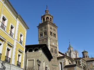
  1. Tower, roof and dome of the Cathedral of Saint Mary of Mediavilla, also known as the Teruel Cathedral. This is a Roman Catholic Church dedicated to St. Mary.

  2. Tower and church of San Pedro, also known as San Pedro Church. This is a 14th Century church and a 13th Century bell tower in Teruel.

  3. Tower and church of San Martin, built in 1316, and renovated in the 16th Century.

  4. Tower and church of The Savior, also known as the Tower of the church of San Salvador, a Mudejar bell tower and a church.

  5. Apse, cloister and tower of Colegiata de Santa Maria, or the Collegiate church of St Mary Major, a Mudejar-gothic style, Roman Catholic church.

  6. Parish church of Santa Tecla, a church-fortress in the Aragonese Mudejar style.

  7. Church of Saint Mary in Tobed, a church-fortress in the Aragonese Mudejar style.

  8. Mudejar remains of the Palace of Aljaferia, a fortified medieval palace, and the only conserved testimony of a large building of Spanish Islamic architecture.

  9. Tower and Parish church of San Pablo, a Gothic-Mudejar church.

  10. Apse, parish and dome of La Seo, also known as the Cathedral of the Savior of Zaragoza, is a Roman Catholic cathedral in Zaragoza.


Picture Credit : Google


What is the story of our Indian scripts?


The Phonetic Phoenicians


When early forms of writing first developed in different parts of the works humans drew picture symbols to show what they observed in real life. So each symbol represented one object. The Egyptian Hieroglyphs, the Mesopotamian Cuneiform, and the Indus Valley script were all ‘pictorial’ scripts. This meant that to read or write, people had to learn lots and lots of symbols, which was very difficult and took a lot of time.


Around 1500 BC, the ancient Phoenicians, an ancient sea-faring, trading civilization based around what is now Lebanon, came up with a system of writing that would change the world! Symbols were now used for sounds rather than actual words. These sounds became alphabets, which didn’t mean anything by themselves, but could be used as building blocks to form an unlimited number of words. Even unknown words could be spelled out as people now knew how to pronounce them. All cultures which came in contact with this immediately adopted this revolutionary concept, and created their own ‘phonetic’ alphabets.


However, the Chinese alphabet remains pictorial. So while writers of most languages of the world have to learn, and focus only on building their vocabulary, the average Chinese person today has to learn, by heart, between 3,000 and 50,000 characters just to be able to read her language!


The Greeks and Roman scripts became the base for the European language scripts used today. The Hebrews* and Arabs modified Phoenician differently and created their own scripts, including the Aramaic script, which was adopted as the official script of the Persian Empire. With the Persian conquests of the Indus area in the 6th century BC, the Aramaic script came to India.


Origin of Indian scripts


In India, the Harappan script was by then a long forgotten mystery. After a gap of thousands of years, the earliest inscriptions are from the Mauryan period, in the Hathigumpha in Orissa, and the Ashokan edicts in the 3rd century in a script called Brahmi. Interestingly, Emperor Ashoka’s very first edict, carved into a rock near Kandahar around 260 BC, was written exclusively in Aramaic and Greek!


However, Brahmi and other scripts had probably been gradually evolving for a long time in India and it is just that the oldest ones we have found are from the Maurayan period, as they started carving things into durable stone, rather than writing on wood or paper.


Brahmi would become the mother of all South Asian and most South-East Asian scripts – around 15 of them – from Hindi to Punjabi to Bengali to Tamil to Burmese, Thai and Tibetan!


Variations in Brahmi


Like languages, scripts also change across different regions. Brahmi quickly started getting regional variations. Around the 1st century, there was a distinct split between Northern Brahmi and Southern Brahmi , which diverged more and more over time. Northern Brahmi evolved into all the north Indian scripts we have today, like Gurmukhi, Devanagari, Marathi, Bengali and so on. Southern Brahmi gradually morphed into the Old Kannada, Pallava grantha and Vattelutu scripts, which gave rise to modern Tamil, Telugu, Kannada and Malayalam.


The South-East Asian Connection


The Pallava dynasty ruled a large swathe of southern India around the 3rd-9th centuries AD. In their time, a script called Pallava Grantha was used. The Pallavas developed strong trading ties with many countries in South-East Asia, and not just goods, but Indian culture, religion, mythology and even the script spread to countries like modern Burma, Indonesia, Thailand Cambodia and Vietnam. All of their scripts come from Pallava Grantha!


Vowels and Consonants


Have you ever wondered why, in English, vowels are written as separate letters, but in Indian scripts, the vowels are added to the top, bottom or side of the consonants> this is special feature of all Brahmic scripts. While it makes learning to write a bit more complicated, it is at least less complicated than Semitic languages like Arabic and Hebrew…which simply don’t have vowel sounds! Readers of those languages have to guess what the word is while reading the paragraph!


Picture Credit : Google


What is the history of Roman Walls of Lugo in Spain?


About the site


Built in the latter part of the third century to defend the Roman town of Lucus (now, Lugo), the Roman Walls of Lugo are one of the finest examples of late Roman fortification is Western Europe. Situated in the region of Galicia in north-western Spain, these walls contain the city of Lugo, the world’s only city that is completely surrounded by ancient Roman walls. Stretching about two km around the city, these fortifications were added to the UNESCO World Heritage List in 2000. Most of the original structure remains intact.


The walls


The walls of the fortification are faced with stones such as slate and granite, and the core of the wall is a combination of gravel, pebbles and Roman stone recycled from demolished buildings. The heights of the walls vary between eight and 12 metres, with a width of about four metres stretching to seven metres at some points.


The walls contain 85 external towers, ten gates, four staircases and two ramps which provide access to the walkway along the top of the walls.


When they were first built, each of the towers contained access stairs leading from the intervallum (the clearing between the walls and the city) to the walkway. Of these, 21 stairways have been discovered so far.


The gates


A total of ten gates are present along the fortifications. Five of these are from the Roman times, while the remaining were added in 1853 to accommodate the town’s expanding population. The best preserved gates are the Porta Falsa and the Porta Mina. Porta Mina still has its original vaulted arch set between two towers.


The towers


Of the original 85 towers, 49 are intact and the remaining have partially survived. Built at irregular intervals along the walls of the fortification, the towers are two-storeyed and are mostly semicircular. A few of them are rectangular. A mix of materials was said to be used to construct the tower. Most often, the base of the tower was built in dressed granite, with the remainder in slate.


The fortification today


Over the years renovation work has been carried out on the fortification. Most part of the original layout and features such as towers, battlements, stairways, the modern and original gates, and a moat have been retained.


Today, a walkway over the walls allows visitors to stroll the entire length of the fortification, and a popular festival called Arde Lucus is held every year to celebrate the city’s Roman past.


Picture Credit : Google


Which are the important artefacts of Mohenjo Daro?


Several artefacts and relics were unearthed during the excavation of Mohenjo Daro by archaeologists. Most of these are preserved and on display at the National Museum, New Delhi. Some of the notable artefacts discovered are:


The Dancing Girl


Dating back to 2,500 BC, this is one of the rarest artefacts found the world-over. The artifact depicts a woman who looks like she is dancing. Hence, the name ‘Dancing Girl’. The bronze statue suggests two important facts about the Indus Valley Civilisation – the artists knew metal blending and casting, and the civilisation had dance and other performing arts as modes of entertainment.


Mother Goddess idol


Discovered in 1931 by Hohn Marshall, this terracotta idol was made between 2700 and 2100 BC. According to archaeologists, the figurine suggests the Mother Goddess cult was wide-spread during the days of the Indus Valley Civilisation.


The Priest King


Discovered in 1927, and sculpted around 2,500 BC, this is a statue of a seated male with a neat beard, pierced ears, and a fillet around his head. He also wears a clock and an armband. The statue, which is 17.5 cm tall, is made of soapstone.


Though there is no evidence of a king or a priest having ruled Mohenjo Daro, archeologists dubbed this figure the ‘Priest King’.


Pashupati Seal


Engraved between 2500-2400 BC, this artefacts is considered one of the most significant Indus finds. It is a seal which bears the image of Shiva, suggesting the existence of a Shiva-cult during the Indus civilization. The seal is engraved on a chip of steatite, a soft stone which is decay-resistant.


Present state


Many archaeologists believe that not must is being done to protect the ruins. The faces challenges from rising temperatures, which sometimes soar over 46 degrees Celsius. Salt from the underground water table is also said to be damaging the ruins.


More than the weather and time, archaeologists believe that it is fight against militancy and neglect by people that will lead to the eventual disappearance of the ruins.


Picture Credit : Google


What is the history of Mohenjo Daro?


The ancient city


Situated in the modern-day Larkana district of Sindh province in Pakistan, Mohenjo Daro was ince a thriving city of the Indus Valley Civilisation. Built around 2,500 BC Mohenjo Daro meaning mound of the dead, is considered one of the world’s earliest well-planned cities. It was abandoned in the 19th Century BC with the decline of the Indus Valley Civilisation. It was rediscovered in the 1920s by an officer at the Archaeological Survey of India.


Following its discovery, several excavations have been carried out at the site, with only-third of the city’s area of 240 hectares excavated so far. The excavations have revealed evidence of art, religion, customs and administrative abilities of the Indus Valley Civilisation, along with the city’s excellent drainage system.


The site was added to the World Heritage Site list in 1980 by UNESCO for being the most ancient and best-preserved urban ruin in the Indus Valley and bearing testimony to the Indus civilization.


Architecture and layout


The city of Mohenjo Daro had been carefully planned. Spread across 240 acres, it is believed that the city once housed nearly 40,000 people. Its layout has rectilinear buildings on a grid plan and an elaborate drainage system. Most of the buildings in Mohenjo Daro were build of fired and mortared brick, with some incorporating sun-dried mud-brick and wooden superstructures.


The site consists of several mounds, which archaeologists believe grew organically over the centuries as platforms and walls were constantly built for the houses. The Great Bath, water light pool, and one of the major constructions in Mohenjo Daro, sites on the tallest mound in the city. Many believe that the Great Bath is the closest structure that Mohenjo Daro has to a temple. Next to the Great bath is the Great Hall or Great Granary, with wall divisions and air ducts.


The city had a central marketplace with a large central well. Most of the houses contained a bathing area with a drainage system. They also had inner courtyards and some were two-storeyed.


Picture Credit : Google


What is the history of the Whale Sanctuary of El Vizcaino?


A serial property on the Pacific Coast of the central part of Mexico Baja California Peninsula, the Whale Sanctuary of EL Vizcaino comprises two coastal lagoons – Laguna Ojo de Liebre and Laguna San Ignacio. The site includes the wetlands, marshes, dunes, halophytes, mangroves and desert habitats surrounding the lagoons. Spanning nearly 400,000 hectares, the World Heritage Site is part of the much larger El Vizcaino Biosphere Reserve, Mexico’s largest protected area. The lagoons of El Vizcaino are recognised as the world’s moat important place for the breeding and reproduction of the once endangered Eastern subpopulation of the North Pacific Grey Whale.


The ideal spot


Every year between December and March, many Grey whales come to the sanctuary from the oceans of Alaska to breed. Nearly half the population of gray whales found in the world today is believed to have been born in this sanctuary.


One of the major reasons for the whales making their way here is the high temperature and saline concentration of the lagoon waters, which make it ideal for newborn calves to learn how to float and swim. The shallow waters of the lagoon also help the calves learn how to feed themselves. This is why the sanctuary is known as “The Whales’ Cradle”.


The return of the grey whales


While the current population of the grey whale is estimated to be about 20,000, there was a time when the species was on the verge of extinction. The population had come down to just 200 in the beginning of the 20th Century due to overhunting, including in this very sanctuary. However, due to the local government’s strict protection policy as well as the accreditation of El Vizcaino as a biosphere reserve and later as a World Heritage Site, the grey whales have returned and improved in numbers.


A sanctuary to many others


The lagoons of the sanctuary are home to numerous other marine mammals such as the bottlenose dolphin, California sea lion, blue whale and the harbor seal. Four species of endangered marine turtles can also be found in the lagoon. These are the leatherback, green, hawksbill, and olive ridley turtles. The shallow waters of the lagoon serve as an important habitat and nursery for a large number of fish, crustaceans, and other forms of life. Many breeding as well as migratory bird species such as the brant goose depend on the lagoons and their surrounding habitats.


Picture Credit : Google


What is the history of Harappan civilization?


Princess Enheduanna, daughter of the great king Sargon of Akkad in Mesopotamia, paced about impatient for the latest shipment from Meluha. She wanted a new dress made of ultra-fine cotton, printed with a striking pattern of blue, red and yellow, or maybe a slightly thicker cotton, striped blue and cream. She had heard they even had this really fine soft wool that you could actually draw through a ring. But their jewellery was simply the best! She had her heart set on a long necklace of carved carnelian and gold.


Chic clothes


Meluha was what the Mespotamians called the ancient Harappan civilization. So how did ancient Harappans dress?


The most common fabric was, of course cotton, which was native to India. It was woven thick, or fine and gauze-like. It was used in its natural colour, or dyed in many shades – a rich blue with indigo, red with the madder plant, or yellow with turmeric. Patterns were often created by weaving – fabric woven in coloured solid stripes, or with different colours in warp and weft, creating a shimmery look like the still used Khes material in Punjab. The fabrics were also printed in patterns using many colours, similar to Ajrakh printing in Gujarat today. The shawl in the famous statue of the Priest King is an example of fabric printed in such a pattern. Clothes could be embroidered or studded with buttons made of terracotta, ivory, and if you were rich, gold sequins!


They also used wool, both coarser varieties from sheep, and finer varieties similar to Pashmina and Shatoosh. Native Indian varieties of silk like Tussar have been found, as have hemp and jute fibres. Most garments seem to have been unstitched and draped in various patterns, similar to those worn in much of India today.


Woman wore short knee-length skirts, or longer ones that reached their calves. Men wore something which looked sort of like a dhoti. Some would also drape a fabric over their upper halves. Men wore turbans or conical caps.


Even animals were dressed well – often covered with blankets to protect them from the cold or insects. Painted deigns on some terracotta figurines suggest that some of these blankets may have been embroidered or woven with patterns. Think of the brightly festooned camels and elephants you see in India today!


Seem like a lot of what we do today harks back to the Harappans!


Hip Hairdos


Woman had very elaborate hair styles – with braids, buns, ringlets or left loose. They also used really small beads (1 man) to bead up their hair (like an afro possibly!) They would use kajal made from antimony, face powders and other cosmetics and used burnished copper mirrors to view themselves. Mehendi was also grown.


Jazzy jewellery


The Indian passion for jewellery is a long standing one it seems, as both Harappan men and women wore a lot of it! Men wore head bands, bead necklaces and bangles, while women draped themselves with bangles, earrings, rings, anklets, belts, pendants, chokers and necklaces of all lengths…phew!


The jewellery was made of gold, silver, ivory, gemstones, or if you were not so rich, shell, bones or even mud (terracotta)! Hundreds of clay bangles have been found – painted in different colours. They would often be worn to cover the entire arm, like the famous dancing girl statue, and still worn by some tribal people in Rajasthan.


One of the crafts that the Indus people had really mastered was that of bead-making. The beads were made from semiprecious stones such as steatite, agate, camelian, lapis lazuli, other materials such as shell and terracotta, and even some from gold, silver and copper.


Bead-making was time consuming as the drilling and polishing had to be done carefully by hand (no electricity!) and people who were able to afford these beads would have been well-off. In fact, a belt was found with thirty six very long camelian bedas, each of which would have taken a skilled craftsman about two weeks to make. So thirty six beads represent the full time work of more than a year, and we can be sure that the owner of the belt would have been very rich indeed. Imitation goods is by no means a modern business, and for the not so well off, the Indus Valley bead-makers also produced imitation beads out of baked terracotta and painted them red to resemble camelian beads.


The Harappas acquired gold by trade from Mesopotamia, by panning it from the banks of the Indus River, or from the mines in Kolar in South India, by bartering with the local Neolithic tribal people. In fact, the tribal people may have been slightly short-changed in these transactions as cheao steatite paste beads, which were made from the waste stone powder generated while seal making, have been found near this region. Of course all these fabulous Indian products were exported as far as Mesopotamia!


Picture Credit : Google


Which civilization flourished in North Africa at the same time as the Harappans?


The Indus Valley Civilisation (IVC) was a Bronze Age civilisation in the northwestern regions of South Asia, lasting from 3300 BCE to 1300 BCE, and in its mature form from 2600 BCE to 1900 BCE. Together with ancient Egypt and Mesopotamia, it was one of three early civilisations of the Near East and South Asia, and of the three, the most widespread, its sites spanning an area stretching from northeast Afghanistan, through much of Pakistan, and into western and northwestern India. It flourished in the basins of the Indus River, which flows through the length of Pakistan, and along a system of perennial, mostly monsoon-fed, rivers that once coursed in the vicinity of the seasonal Ghaggar-Hakra river in northwest India and eastern Pakistan.


The Indus civilisation is also known as the Harappan Civilisation, after its type site, Harappa, the first of its sites to be excavated early in the 20th century in what was then the Punjab province of British India and now is Pakistan. The discovery of Harappa and soon afterwards Mohenjo-daro was the culmination of work beginning in 1861 with the founding of the Archaeological Survey of India during the British Raj. There were however earlier and later cultures often called Early Harappan and Late Harappan in the same area; for this reason, the Harappan civilisation is sometimes called the Mature Harappan to distinguish it from these other cultures. By 2002, over 1,000 Mature Harappan cities and settlements had been reported, of which just under a hundred had been excavated, However, there are only five major urban sites Harappa, Mohenjo-daro (UNESCO World Heritage Site), Dholavira, Ganeriwala in Cholistan, and Rakhigarhi. The early Harappan cultures were preceded by local Neolithic agricultural villages, from which the river plains were populated.


Picture Credit : Google


Dholavira is in which state?


Dholavira is an archaeological site at Khadirbet in Bhachau Taluka of Kutch District, in the state of Gujarat in western India, which has taken its name from a modern-day village 1 kilometre (0.62 mi) south of it. This village is 165 km (103 mi) from Radhanpur. Also known locally as Kotada timba, the site contains ruins of an ancient Indus Valley Civilization/Harappan city.


The site was discovered in 1967-68 by J. P. Joshi, of the Archaeological Survey of India (ASI), and is the fifth largest of eight major Harappan sites. It has been under excavation since 1990 by the ASI, which opined that "Dholavira has indeed added new dimensions to personality of Indus Valley Civilisation." The other major Harappan sites discovered so far are Harappa, Mohenjo-daro, Ganeriwala, Rakhigarhi, Kalibangan, Rupnagar and Lothal.


The acropolis and the middle town had been furnished with their own defence-work, gateways, built-up areas, street system, wells, and large open spaces. The acropolis is the most thoroughly fortified and complex area in the city, of which it appropriates the major portion of the southwestern zone. The towering "castle" stands is defended by double ramparts. Next to this stands a place called the 'bailey' where important officials lived. The city within the general fortifications accounts for 48 ha (120 acres). There are extensive structure-bearing areas which are outside yet integral to the fortified settlement. Beyond the walls, another settlement has been found. The most striking feature of the city is that all of its buildings, at least in their present state of preservation, are built of stone, whereas most other Harappan sites, including Harappa itself and Mohenjo-daro, are almost exclusively built of brick. Dholavira is flanked by two storm water channels; the Mansar in the north, and the Manhar in the south.


Picture Credit : Google


Which native Indian tree, sacred to the Hindus and particularly to the Buddhists, was also important in the Harappan civilization?


The worship of trees was widespread. The Pipal tree was considered most sacred. One of the seals shows a god standing between the branches of a people tree and the god was being worshipped by a devotee on his knees. The discovery of a large number of seals with papal trees engraved on them suggests that this tree was considered sacred, same as some nowadays Hindu do.


People also worshipped animals such as the bull, buffalo and tiger. The worship of mythical animals is evident from the existence of a human figure with a bull's horns, hoofs and a tail. Besides animals, these people also worshipped the Sun, the Fire and the Water.


The people of Indus Valley disposed of their dead either by burial or by cremation. They buried their dead together with household pottery, ornaments and other articles of daily use. Even when they cremated the dead, they preserved the ashes of the bodies in clay urns. Both these practices show that people believed in life after death.


The existence of public baths suggests that people believed in ritual bathing. The religious beliefs such as the worship of Shiva, animals and trees, show that the religious beliefs of the Indus Valley people were the foundation on which the modern day Hinduism grew up.


Picture Credit : Google


Which Harappan site north of Delhi is the largest city discovered so far?


Rakhigarhi encompasses a set of seven mounds, and there are many more settlement mounds in the immediate vicinity. Not all of them were occupied at the same time. Depending on which mounds to include, the estimates of the size of Rakhigarhi have been given variously as between 80 and 550 hectares. In January 2014, the discovery of additional mounds resulted in it becoming the largest Indus Valley Civilization site, overtaking Mohenjodaro (300 hectares) by almost 50 hectares, resulting in almost 350 hectares.


The size and uniqueness of Rakhigarhi has drawn much attention of archaeologists all over the world. It is nearer to Delhi than other major sites, indicating the spread of the Indus Valley Civilization east across North India. Much of the area is yet to be excavated and published. Another related site in the area is Mitathal, which is still awaiting excavation.


In May 2012, the Global Heritage Fund, declared Rakhigarhi one of the ten most endangered heritage sites in Asia. A study by the Sunday Times, found that the site is not being looked after, the iron boundary wall is broken, and villagers sell the artefacts they dig out of the site and parts of site are now being encroached by private houses.


Picture Credit : Google


Which was the main metal used for tools and weapons by the Harappan civilization?


Harappan objects were made of stone, Shell, and metal. Copper and bronze were used to make tools, weapons, ornaments, and vessels. Gold and silver were used to make ornaments and vessels. Harappans also made stone seals. They made pots with beautiful black designs. Bricks were so well made that they had seemed to have lasted for thousands of years and were laid in an interlocking pattern which made the walls strong. About a hundred and fifty years ago, many of these bricks were taken away by engineers.


People built one or two-story houses on either side of the roads with rooms built around a courtyard. The Harappan city had a well-planned drainage system where every house had a drain connected to the street drains which further were connected to the bigger drains. The drains were also covered with the stone slabs that were laid in straight lines along with inspection holes for the cleanup purpose.


Picture Credit : Google


Why did the Berlin Wall come down in 1989?


The Wall and attempts to cross it


Willi Seifert, commander of the GDR’s interior troops was tasked with erecting the barrier. Constructed in August 1961, the Berlin Wall was actually two walls separated by a heavily guarded, mined corridor of land known as the “death strip”. There was also around 50km of heavy wire mesh, existing cemetery walls and house facades that made up part of the Wall. The entire length of the Wall was 163 km.


Lined with nearly 300 watchtowers, the Wall was under the constant surveillance of the East German border guards. They were authorized to shoot at anyone attempting to cross the Wall.


Several attempts were made by people to cross over the Berlin Wall. It claimed the lives of at least 140 people. The most public incident of the attempt to cross over was that of Peter Fetcher. Peter and his friend, both teenagers, sprinted across no-man’s land near a border crossing-point nicknamed Checkpoint Charlie on August 17, 1962. While his friend made it over, 18-year-old Peter was shot in the back and collapsed. As western photographers pleaded with the guards to rescue the teen, the guards refused to help.


Amidst the lull, there were several East Germans who managed to cross the Wall using different ways. While some used sports cars and armoured trucks, some dug tunnels and built a hot air balloon.


The fall of the Wall


Things started to deteriorate for the Eastern bloc in the 1980s with the start of an energy crisis and political struggle within the bloc. Rising civil unrest also put pressure on the East Germany government. However, what started the downfall of the GDR was the fall of the Iron Curtain between Hungary and Austria. The opening of that border led to several East Germans migrating to West Germany through Hungary. However, this attempt was quickly blocked, but East Germans began to camp at West German embassies across the Eastern bloc and refused to return. Meanwhile, demonstrations began within East Germany in full swing.


East Germany was pressured to relax some of its regulations on travel to West Germany. On November 9, 1989, at a pressconference to announce the same, East German spokesman Gunter Schabowski announced that East Germans would be free to travel into West Germany, starting immediately. However, he failed to clarify that some regulations would still apply. This led to the western media reporting that the border had been opened, leading to large crowds gathering at either side of the checkpoints. Eventually, passport checks were abandoned and people crossed the border unrestricted.


The Berlin Wall had fallen, and this fall marked the beginning of the unification of Germany, which took place on October 3, 1990.


Picture Credit : Google


What is the history of Berlin Wall?


A guarded concrete wall that physically and ideologically divided Germany’s capital, the Berlin Wall stood tall between 1961 and 1989.


Construction of the Wall commenced on August 13, 1961 by the German Democratic Republic (GDR) to ensure people from East Germany did not emigrate to West Germany. The Wall finally fell on November 9, 1989 after East Germany declared all the crossing points along the wall open.


Backdrop to the building of the Wall


In 1949, a war-torn Germany formally split into two independent nations – the Federal Republic of Germany and the German Democratic Republic – with the FDR allied to the western democracies led by the U.S. and the GDR allied to the Soviet Union led by Russia. These superpowers had growing geopolitical tension between them, in what is today known as the Cold War. The city of Berlin, was at the centre of this heated split, with one part under the Eastern bloc and the remaining three with the West under the U.S, Britain and France.


Why was the Wall built?


Free flow of people between the two parts was allowed through Berlin as East Germany had sealed its mainland border from the West along the Elbe river and the mountains of Harz with barbed wire and fire zones.


As time passed, many people from East Germany migrated to the West in search of better jobs and infrastructure.


One in six people fled from the East to the West. This irked the GDR as its economy was deeply affected due to this ‘brain drain’. Thus, in a bid to halt this migration, East German communists were given the permission by Moscow to close the border and build a physical barrier along it.


With information from their informers in the western part that the West will not react, East German Police, in a top-secret operation, established a human cordon along the border with West Berlin. The border forces then went on to build a solid breeze-block wall trapped with barbed wire, from what was earlier just provisional wire-mesh fences.


Picture Credit : Google


What do the scrolls contain? What are the challenges in unwrapping these scrolls?


The scrolls are believed to contain mostly Greek philosophy. They may also provide insights into the lives of ancient Romans.


The hot ash and gases from the volcanic eruptions have charred and carbonized the scrolls, turning many into impenetrable log-like cylinders. The scrolls are also too fragile to unfurl and various attempts at unrolling the scrolls and deciphering the texts over the last 270 years, have mostly failed. Many scrolls have been damaged in the process.


Further, in the Herculaneum scrolls, the script has been written with carbon ink, unlike many ancient texts that were written with metal-based inks. The use of carbon ink is one of the main reasons these scrolls have evaded deciphering. Unlike metal-based inks, its density is similar to that of the carbonized papyrus on which its sits, and therefore appears invisible in X-rays.


Other challenges: Even if a scroll is successfully opened, the original ink – exposed to air – would begin to fade. In addition, this form of unrolling often leads to pages getting stuck together or damaged.


Scientists use the X-ray beam at Diamond Light Source and a virtual unwrapping software to detect the carbon ink on the scrolls. The technology is similar to a CT scanner where one would take a three-dimensional image of a person and then examine different organs.


Scientists will shine very intense light through the scroll, which will deliver three-dimensional images on the other side. From that, a three-dimensional image of the text will be constructed. The idea is to read the text in a non-destructive manner. But the digital scan is only the first step in the decoding process.


The research team is building a machine-learning algorithm that will go through the digital scan of the scrolls to detect evidence of ink. The text will have to be later deciphered.


Picture Credit : Google