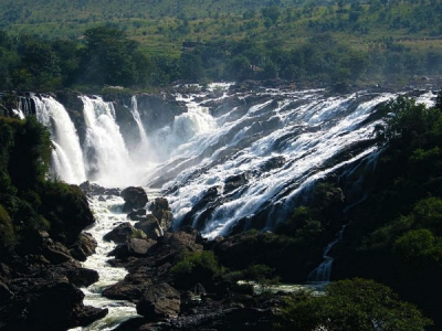
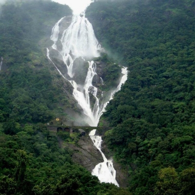
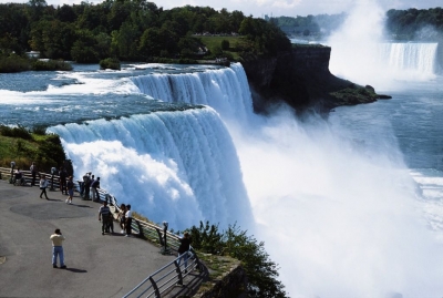
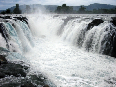
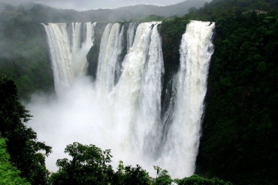
Is a waterfall a river?


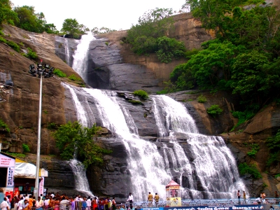
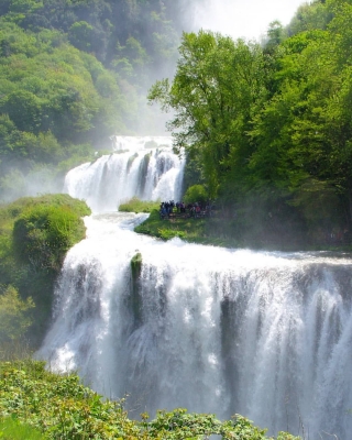
A waterfall is a river or other body of water's steep fall over a rocky ledge into a plunge pool below. Waterfalls are also called cascades.


Often, waterfalls form as streams flow from soft rock to hard rock. This happens both laterally (as a stream flows across the earth) and vertically (as the stream drops in a waterfall). Many waterfalls in an area help geologists and hydrologists determine a region's fall line and underlying rock structure.


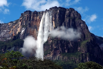
Waterfalls are also classified by height. Angel Falls, the world’s tallest waterfall, plummets 979 meters (3,212 feet) into a remote canyon in a rain forest in Venezuela. The water, from the Gauja River, often does not reach the bottom. The fall is so long, and so steep, that air pressure is stronger often than the water pressure of the falls. The water is turned to mist before it reaches the small tributary below.


Picture Credit : Google


In which river does Shivanasamudra Falls originate?


The Shivanasamudra Falls is on the Kaveri River after the river has found its way through the rocks and ravines of the Deccan Plateau and drops off to form waterfalls. The island town of Shivanasamudra divides the river into twin waterfalls. 


Shivanasamudra Falls is a waterfall in Chamarajanagar District of the state of Karnataka, India. It is situated along the river Kaveri, which forms here the boundary to the Mandya, and is the location of one of the first hydro-electric power stations in Asia, which was set up in 1902.The project was designed by Diwan Sheshadri Iyer.


The Gaganachukki waterfalls are best viewed from the Shivanasamudra watch tower. Most of the pictures showing the twin waterfalls are taken from that location. There is another approach to the Gaganachukki falls from the Darga Hazrath Mardane Gaib (Imam Ali). Despite warnings being posted, people climb down the rocks and attempt to view the waterfalls from behind/top, resulting in many fatal accidents. It is 139 km (86 mi) from the city of Bangalore.


Picture Credit : Google


Peraruvi, Aintharuvi, Shenbagadevi Falls and Thenaruvi are part of which famous waterfall in Tamil Nadu?


Courtallam falls is not just one but a set of nine falls settled close to each other in the Tirunelveli district of Tamil Nadu. They are named as Peraruvi (Main Falls), Aintharuvi (Five Falls), Thenaruvi (Honey Falls), Chithirai Aruvi, Puli Aruvi (Tiger Falls), Shenbagadevi Falls, Pazhaya Aruvi (Old Falls), Puthu Aruvi (New Falls) and Pazhathotta Aruvi (Fruit Garden Falls). Besides, what adds more charm to the panoramic surroundings are the Western Ghats and the Chittar river where these famous waterfalls find their home.


Coutrallam Falls is located in Western Ghats to the South of Coutrallam town and to the north of Coutrallam Lower, the first lake in the descent of Chittar. It is located 5 km (3.1 mi) from the nearest town Tenkasi and 59 km (37 mi) from the nearest city Tirunelveli. The place is frequented by animals like Tiger and Panther, which are frequently spotted in the route from Coutrallam Falls to Papansam as both are located close to Kalakkad Mundanthurai Tiger Reserve.


The falls receives its waters during the South-west monsoon from May to September, but the maximum amount of rainfall is received during the North-east monsoon during October to December. The Kutralanathar Temple is located close to the main falls. The falls is usually frequented by devotees of the Papanasanathar Temple, who take a holy dip in the falls before visiting the temple. The falls is also frequented by tourists to Sabarimala during the November - December season in a religious circuit in the region and Agasthiyar Falls.


Picture Credit : Google


Which is the tallest human made waterfall in the world?


The Cascata delle Marmore is an ancient artificial waterfall with a total height of 165 meters makes it the tallest man-made waterfall in the world.


It appears to have been created by the Romans as a means of mitigating perceived health risks from wetlands formed by the source of the waterfall, the river Velino.


The waterfall consists of three discrete sections with the topmost the tallest part at around 83 meters. It is located in the Italian region of Umbria, just under 8km from Terni. 


Most of the time, the water in the canals above the falls is diverted to a hydroelectric power plant, so the flow in the falls themselves is heavily reduced. Piediluco Lake, above the falls, is used as a reservoir for the power plant. The Galleto power plant, built in 1929, is architecturally interesting. Its capacity is about 530 MW. To control the operation of the power plant, and to satisfy tourists, the falls are turned on according to a set schedule, achieving a spectacular effect at full flow.


Picture Credit : Google


In which national park in October, 2019 11 elephants died while trying to save each other after a baby elephant fell from a waterfall?


Six elephants died while trying to save each other after a baby elephant fell from a waterfall in a Thai national park, officials said.


Staff at Khao Yai National Park, about 85 miles northeast of Bangkok, found the roughly 3-year-old baby elephant drowned on Saturday. Five more dead elephants also were discovered at the bottom of Haew Narok Waterfall, according to the Thailand Department of National Parks, Wildlife and Plant Conservation.


Elephants are sympathetic animals that have been known to help each other when they are distressed. They also show something resembling grief when one of their own dies.


Khao Yai is Thailand's third-largest national park. Haew Narok, the park's tallest waterfall, has three tiers that total about 492 feet. Elephants are common nearby.


Picture Credit : Google


Which is the largest waterfall in Kerala?


Athirappilly Falls, is situated in Athirappilly Panchayat in Chalakudy Taluk of Thrissur District in Kerala, India on the Chalakudy River, which originates from the upper reaches of the Western Ghats at the entrance to the Sholayar ranges. It is the largest waterfall in Kerala, which stands tall at 80 feet. 


The 145 kilometres (90 mi) long Chalakudy River, originates in the Anamudi mountains of the Western Ghats[2] and flows through the Vazhachal Forest toward the Arabian Sea. The river initially runs smoothly but becomes more turbulent as it nears Athirapilly. At Athirappilly Falls, the water surges around big rocks and cascades down in three separate plumes. Below the falls, the river remains turbulent for about 1 kilometre (0.62 mi) until it reaches Kannamkuzhi. Then it calms and flows smoothly until reaching the dam at Thumburmuzhi.


Daily jungle safari trips are organized by Thrissur District Tourism Promotion Council with Athirappilly Destination Management Council from Chalakudy to Malakkappara.


Picture Credit : Google


Which waterfall in India literally means Sea of Milk?


One of the most scenic waterfalls in India, Dudhsagar literally means ‘Sea of Milk’. Though perennial, the beauty of the waterfall increases multi-fold during the rainy season. Dudhsagar Waterfall is situated inside the Bhagwan Mahavir wildlife sanctuary in Sanguem district of Goa close to the border with Karnataka. It is about 60 km from state capital Panaji.


The roads leading to the waterfall, maintained by the Goa Forest Department, remain closed during the monsoon and open in October. Trekking to the waterfall is the most popular activity and passes through steep mountain terrain. Jeep safari is also popular with tourists. There are four routes to reach the waterfall. The most adventurous trek starts from Kuveshi village. It is not allowed during monsoon as it requires cross the Mandovi River. The 10 km long route passes through thick jungle.


Legend has it that a beautiful princess lived in the forest on the edge of the King's palace grounds. She enjoyed bathing in a lake nearby and ritually drank sweetened milk from a Golden Jug upon finishing with her bath. One day while enjoying her jug of milk she found herself being watched by a handsome prince standing amongst the trees. Red with embarrassment at her inadequate bathing attire, the Princess poured the jug of milk in front of her to form an improvised curtain to hide her body, while one of the maids rushed to cover her with a dress.


The sweetened milk cascades down the mountain slope to this day as tribute to the virtue and modesty of the Princess.


Picture Credit : Google


Which waterfall features in the film “Harry Potter and the Goblet of Fire”?


Recognize this waterfall? That’s because it appears in the Harry Potter and the Goblet of Fire film while Harry battles the Hungarian Horntail during the first task of the Triwizard Tournament. The Steall Falls, near Fort Williams in the UK, is so popular with walkers that it now needs repairs to its surface due to erosion. On average, 40,000 people a year climb the 393 ft. path up the falls.


Repairs will involve a helicopter because it will be the easiest way to drop necessary materials down on the path. This need and methods used for repair will mean closure for the path and road through Glen Nevis when work needs to be completed on the aerial section.


Goodman also stated, “The trail retains that feel of wildness that people of all ages love.” His statement certainly reflects the popularity of the waterfall and the need to repair the landmark for future climbers.


Picture Credit : Google


Which two countries does the Niagara Falls straddle?


Niagara Falls is a geological wonder and one of the most famous waterfalls in the world. Straddling the border between the United States and Canada, it has been a popular tourist attraction for over 200 years, as well as a major source of hydroelectric power.  


When Niagara Falls formed, it was about 7 miles (11 km) downstream from where it is today. Even now, erosion continues to push the falls farther upstream at a rate of about a foot a year. By some estimates, the river will erode back to Lake Erie in about 50,000 years, cutting through an escarpment and through soft shale and beginning to drain Lake Erie. 


Native Americans settled in the area between A.D. 1300 and 1400, according to Niagara Falls Info. One of the first native tribes called themselves the Onguiaahra, which French explorers turned into "Niagara." Also among the earlier settlers was an Iroquois group, the Atiquandaronk, who were called the "Neutrals" by French explorers because of the tribe's peacekeeping efforts between neighboring warring tribes.


Picture Credit : Google


Horseshoe Falls, American Falls and Bridal Veil Falls collectively make up which popular waterfall?


Niagara Falls in Canada is a collective name given to three waterfalls, namely Horseshoe Falls, American Falls, and Bridal Veil Falls, on the River Niagara along the border of US state of New York and the Canadian province of Ontario. 


Niagara Falls is a collective name given to three separate waterfalls situated on the River Niagara on the border between US state of New York and Canada’s Province of Ontario. The main waterfall, the Horseshoe Falls, lies on the US-Canada border while the American Falls and Bridal Veil are the territories of the USA.


The largest waterfalls of the Niagara Falls is the Horseshoe Falls, which has an average flow rate of 225000 Cubic Feet per second, making it the largest waterfall in North America by flow rate. Over 90% of River Niagara flows into this fall while only 10% goes to the other two combined.


The best time of the day to visit the Niagara Falls, especially during the peak, is just after the opening timing when people are still yet to come or just before the closing time when most people have left.


Picture Credit : Google


The Zamberi river is situated on the border of which two countries?


The 2,574-kilometre-long river (1,599 mi) arises in Zambia and flows through eastern Angola, along the north-eastern border of Namibia and the northern border of Botswana, then along the border between Zambia and Zimbabwe to Mozambique, where it crosses the country to empty into the Indian Ocean.


By far the most notable feature of the Zambezi River is the mighty Victoria Falls – one of the Seven Natural Wonders of the World and World Heritage Site. Not to be disregarded, other well-known falls over which the river cascades are the Chavuma Falls in north-west Zambia, and widely inaccessible Ngonye Falls in western Zambia.


The Kariba Dam (or Lake Kariba) in Zimbabwe, and the Cahora Bassa Dam in Mozambique are both man-made dams constructed to provide hydroelectic power to Zambia and Zimbabwe, and Mozambique and South Africa respectively. 200km from Victoria Falls, Kariba is the world largest man-made lake – 226km long and up to 40km in several places. Cahora Bassa, on the other hand, is an arch dam with a length of 171m and a maximum width of 303m.


Due to the fact that the Zambezi River runs through many game reserves and national parks, it provides sustenance to a diverse array of game, birdlife and fish species. Wildlife to be spotted on a game drive along its banks, or a cruise within its waters include elephant, hippos, crocodiles, water buck, buffalo, zebras, and even lion.


Picture Credit : Google


Why is Hogenakkal named so?


The name Hogenakkal is derived from Kannada words hoge, meaning “smoke” and kal meaning “rock,” because the mist created when the water lands at the bottom of the falls makes it look as if the rocks are smoking.


In the western part of Tamil Nadu in India, the Kaveri River tumbles over rocks to create Hogenakkal Falls. Sometimes called the “Niagara Falls of India,” Hogenakkal Falls is dwarfed in size and strength by the Niagara, but it offers an impressive view nonetheless. The Hogenakkal Falls are formed where the river cuts through the rocky terrain on the border between the two states. The falls are made up of a number of individual waterfalls, which range from about 15 feet to 65 feet tall. 


This place has many waterfalls on the river cauvery. Hogenakkal is a hamlet situated in Tamil Nadu bordering Karnataka.


The 15 km descent from Pennagaram to Hogenakkal snakes through very interesting terrain. In these lands, one can see villages with lush fields of mulberry, fodder for busy silkworms, and the broad-leaved though often scraggy castor. On the outskirts of the rural settlements en route are their fascinating guardian deities, often referred to as Aiyanars. Made of terracotta or plastered brick, these giant figures are brightly colored and generally depict fearsome and mustachioed warriors. But exceptions to this excessively macho rule are also seen at some places.


Picture Credit : Google


In which river does Jog Falls originate?


Jog Falls is a waterfall on the Sharavati river located in the Western Ghats in Siddapur taluk of Uttara Kannada district and its viewpoint is in Sagara taluk, Shimoga district. It is the second highest plunge waterfall in India The Jog Falls are located 18 miles (29 km) upstream from Honavar at the river’s mouth on the Arabian Sea. As it plunges 830 feet (253 metres) into a chasm, the river splits into four cascades known as the Raja, or Horseshoe; Roarer; Rocket; and Ranee (“Queen”), or La Dame Blanche (“The White Lady”). A leading scenic attraction, the falls can be observed from bungalows on either bank of the river. A large hydropower project has been developed at Jog, downstream.


Many smaller waterfalls make an appearance in this area. Even if the main waterfall is completely hidden by mist, which does occur, you are likely to catch a glimpse of the other seasonal waterfalls. The nearby district of Uttara Kannada has plenty of waterfalls too. Sharavathi Valley Viewpoint, Linganamakki Dam, and Muppane backwaters are a few other attractions near Jog Falls. The green paddy fields, tree canopies, and undulating terrain in and around Jog provide an experience which no movie can recreate.


Picture Credit : Google


Why is the Angel Falls named so?


The waterfall has been known as the Angel Falls since the mid-20th century; they are named after Jimmie Angel, a US aviator, who was the first person to fly over the falls. Angel's ashes were scattered over the falls on 2 July 1960.


The common Spanish name Salto Ángel derives from his surname. In 2009, President Hugo Chávez announced his intention to change the name to the purported original indigenous Pemon term ("Kerepakupai Vená", meaning "waterfall of the deepest place"), on the grounds that the nation's most famous landmark should bear an indigenous name. Explaining the name change, Chávez was reported to have said, "This is ours, long before Angel ever arrived there ... this is indigenous land." However, he later said that he would not decree the change of name, but only was defending the use of Kerepakupai Vená.


Picture Credit : Google


In which country will you find the Angel Falls – the highest waterfall in the country?


Angel Falls, Spanish Salto Ángel, also called Salto Churún Merú, waterfall in the Guiana Highlands in Bolívar state, southeastern Venezuela, on the Churún River, a tributary of the Caroní, 160 miles (260 km) southeast of Ciudad Bolívar. Angel Falls in Venezuela is the world's tallest waterfall, with a total height of 3212 feet (979 meters). This total height includes a single uninterrupted drop of 2648 feet (807 meters), plus 564 feet (172 meters) of steep cascades and smaller drops downstream from the main falls.


Angel Falls was named for James Angel, an American pilot, who in 1933 was the first aviator to fly over the falls. Within a few years, Angel's story of a "mile-high waterfall" had been widely publicized through stories and trivia items in popular media. This occurred before the height of the falls was properly measured and before the name Angel Falls was in popular use


Angel falls has been in its current location for thousands of years. It will remain there until gravity pulls another block of the highly fractured sandstone away from the mountain. The block will fall to the ground and explode into a catastrophic rain of rock. The river will flow without interruption, but the position of the waterfall will change.


Picture Credit : Google