Which forest is home to the largest number of wild Asiatic lions?


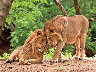
One of the very few places in the world for spotting lions in the wild, the Gir forest is home to the largest number of wild Asiatic lions. Located in southern Gujarat, the region was first declared a reserve forest, and eventually granted the status of a sanctuary in 1965. The Gir National Park and Wildlife Sanctuary is a dry scrubland spanning 1,400 sq.km. Around half of the forested area of the park is teak. The other half mostly has broad leaf and evergreen trees. The entire region is covered with dry deciduous forests, acacia scrub and grassland, and fed by rivers and reservoirs. Dominated by vegetation ideal for fauna, it is no surprise that over 250 species of birds are found in and around the area. This includes a whole variety from teals, kingfishers, nightjars and swifts to eagles, vultures, harriers, ibises and the oriental white-eye. While the lion is the most popular inhabitant of the Gir forest, the region also hosts the leopard, hyena, wild boar, spotted deer, nilgai, jackal, jungle cat, honey badger, porcupine etc. and reptiles such as Indian cobra and the marsh crocodile.


An unusual journey


The last time a tiger roamed Gujarat’s forest was in 1992. However, that changed in February 2019 when a school teacher saw a tiger crossing a road and took a photo on a phone. Having a big cat back in Gujarat was a huge moment of ecological victory. While the image went viral, the forest department got into action – camera traps were set up. Within a week, the tiger was spotted again; it was a young male. The same one that had started its journey from Ratapani Wildlife Sanctuary in neighbouring State Madhya Pradesh back in 2017. When it reached Gujarat, it had travelled about 300 km, one of the longest journeys for tiger. The hope was that the tiger could eventually reach Gir forest, where it would settle in a conductive environment full of prey. However, the tiger died within weeks – of starvation. When it roamed the forests in Gujarat, the State became the only one to host the lion, the tiger and the leopard. That joy turned out to be short-lived. However, the tiger also left behind hope that someday someone else from his species would follow him and perhaps ensure that the joy lasts forever.


Lion deaths


On June 10, 2020 Prime Minister Narendra Modi tweeted that “Population of the majestic Asiatic Lion, living in Gujarat’s Gir forest, is up by almost 29% Geographically, distribution area is up by 36%.” While this was comforting news, a report released by the government around the same time wasn’t. it said that as many as 92 lions had died in Gujarat’s Asiatic Lion Landscape (ALL) since January 2020. ALL includes Gir National Park and Sanctuary, among a few other regions. These numbers are worrying, especially due to the canine distemper virus (CDV) outbreak that occurred in 2018. The virus infection had claimed the lives of more than 20 lions in Gir forest division in a matter of weeks. While the 92 lions “reportedly died of unnatural causes” this year, the State government has denied the presence of CDV.


Picture Credit : Google


According to the latest report from the government, which tiger reserve has recorded the highest tiger density in the country?


Uttarakhand’s Corbett Tiger Reserve (CTR) has reported the highest tiger density among India’s 50 reserves with 14 tigers per 100 sq km, followed by Kaziranga, Nagarhole and Orang tiger reserves, according to the 656-page report ‘Status of Tigers Co-predators and Prey in India’, released by Union environment minister Prakash Javadekar on Tuesday on the eve of Global Tiger Day.


Corbett Tiger Park was the first to come under the Project Tiger initiative and also the oldest national park in India. As per the current tiger counting Jim Corbett Tiger Reserve sheltering a healthy population of tigers and other rare species of plants and a diverse variety of fauna including crested serpent eagle,Himalayan black bear and great Indian elephants.


According to All India Tiger Estimation Report 2018 released by Prime Minister Narendra Modi in July last year in July, there are 442 tigers in Uttarakhand. 


The population of India's national animal in the hill state has registered an increase from 178 in the year 2006, 227 in 2010, 340 in 2014 and 442 in 2018.


Picture Credit : Google


What is a landslide?


A landslide is the movement of a mass of rock, debris, or earth down a slope. Events such as heavy rainfall, earthquake and volcanic eruption can trigger a landslide, but they are not the only causes. More often than not, it is a combination of factors that lead to landslides. Geologists call landslides a type of “mass wasting,” which means any slope movement of soil and rock. The surface gets worn away as a result. Landslides could pose major hazards to people and property.


Underwater landslides resulting from factors such as earthquake are common too. These are called submarine landslides, which in turn can lead to tsunamis.


Geological factors


Landslides occur when the slope undergoes some processes that change its condition from stable to unstable. These could be due to geology and human activity. The geological factor concerns the material that forms the slope and the land. Some material with a loose, open sediment structure will weaken if they are disturbed or flooded with water. Absence of vegetation (or loss of it due to fire or drought), erosion and physical and chemical weathering are some of the geological factors that lead to landslides.


Human activities


Human activities such as deforestation (removal of deep-rooted vegetation), cultivation, building of roads and structures (without adequate grading of slopes), mining and blasting can destabilise or weaken a slope. Irrigation and vibration from machinery or traffic can also increase the risk of landslides.


Hazards can be mitigated by restricting or even removing populations from areas with a history of landslides and by restricting certain types of land use.


Picture Credit : Google


WORLD ATLAS - NORTHERN AFRICA


The northern half of Africa stretches down from the fertile coast bordering the Mediterranean Sea, through vast areas of desert and savanna, into the forests of the west and central Africa. Apart from the Atlas Mountains, the Ethiopian Highlands and Saharan ranges, much of the region is a level plateau.


In the far north of Africa, the countries bordering the coast benefit from natural resources of oil and gas. They also rely on tourism and the manufacture of textiles and carpets. The population is mostly Arabs. Berbers, an ancient native people, live in the uplands of Morocco.


South of the Sahara, agriculture is the primary industry of many countries. Rivers such as the Nile, Niger and Senegal provide essential water with which to irrigate crops. However, in many countries such as Mauritania and Mali, drought is a recurrent problem. In the driest areas, nomadic cattle-herders travel vast distances in search of good grazing.


There are many different peoples living in Northern Africa. Conflict between them often leads to long and devastating wars. The combination of war, drought and widespread poverty has led to terrible famines in Ethiopia and Sudan.


West Africa has a wetter climate, and crops such as coffee, bananas, cocoa, groundnuts and citrus fruits are grown. For many years, timber has been an important product of countries such as the Cote d’Ivoire, but this was carried out at such a rate that vast areas of the forest have now disappeared. Mining of oil and metal ores is a rich resource, but due to poor government and frequent wars, many countries are still impoverished.


Many people in Northern Africa live in small towns or villages, producing just enough food and goods for themselves. Others crowd into the cities, looking for work. They often have to live in very poor conditions on the outskirts of the city.


Picture Credit : Google


WORLD ATLAS - SOUTHERN AFRICA


The Congo basin covers much of central Africa. Here, the mighty Congo River winds through dense rainforest, where animals such as the rare mountain gorilla and a host of bird species live.


 To the south and east are high plateaux, with a cooler, drier climate. Much of the land is flat grassland, called savanna, where animals such as giraffes, elephants and lions roam. In the southwest, the savanna gives way to areas of hot, dry desert. In the east, deep valleys, high volcanic mountains and huge lakes have formed along a split in the Earth’s crust, known as the Great Rift Valley.


Southern Africa is rich in natural resources such as oil, metals (particularly copper and gold) and diamonds. Mining is therefore a vitally important industry. Tourism is also important to the savanna regions, where large national parks have been set up to protect the wildlife. In the eastern highlands, crops of tea and coffee are grown for export. Cattle are farmed for their meat and dairy products.


Outside South Africa and the Copper Belt (southern Congo and northern Zambia), large industrial areas are scarce. Countries such as Angola and Mozambique, with fertile land and rich resources, are nevertheless poverty-stricken due to years of civil war. Many people are farmers, and produce only enough food for themselves.


There are many hundreds of different tribal groups in Southern Africa, with many different languages and customs. Violent clashes between rival groups are frequent. In the worst affected regions, millions of people have fled to neighbouring countries to escape the conflicts.


Picture Credit : Google


WORLD ATLAS - AFRICA


The second largest continent after Asia, Africa is almost completely surrounded by water, apart from the narrow point at which it joins on to Asia. The north of the continent is mostly hot, barren desert, edged with coastal areas that are cooler and wetter in winter.


Further south, the desert gives way to areas of flat grassland. The Equator runs right through the centre of Africa. The countries on or close to the Equator are dominated by the largest area of tropical rainforest outside South America. Here the climate is hot and wet.


The rainforest is home to many different plants and animals, including gorillas and chimpanzees. Many rivers weave their way through central Africa. To the east and south are large areas of open grassland scattered with trees, known as savanna. Animals such as elephants, zebra and wildebeest, roam the savanna, along with predators such as lions, wild dogs and hyenas.


AFRICAN PEOPLES


North of the Sahara desert, the people of Africa are mainly Arabs and Berbers, who follow the religion of Islam. South of the Sahara, most people are black. They follow a variety of religions. Much of Africa was at one time controlled by Europe, and today people of European descent still live there, mostly in the south.


Africa exports its natural resources of metals and oil, as well as crops such as coffee and cocoa. However, many African countries are poor compared to the rest of the world. Few have established manufacturing industries. Most people live in the countryside, and rely on producing only enough crops, or farming enough cattle to support their families. They suffer from frequent droughts, floods and periods of starvation. Wars between and within countries also threaten their lives.


SAHARA DESERT


The world’s largest desert, the Sahara stretches across an area of Northern Africa that is almost the size of the USA. It is constantly growing larger as the sparse grassland at its edges dies away. The Sahara is a hot desert, where rain may fail to fall for years on end. During the day, temperatures can reach over 50°C in the shade, but nights are often cold. There are areas of sand that often drift into large dunes, but much of the Sahara is made up of rocky ground and mountains.


Despite these harsh conditions, the Sahara desert is not without life. Animals that are specially adapted for life with little water and intense heat can survive there. Many take shelter in burrows during the day, coming out at night to feed.


People also live in the Sahara desert. Small towns are able to survive around oases in the desert. Groups of nomads also travel across the harsh landscape to trade in the town markets. For thousands of years, they carried their goods and supplies by camel, an animal that can cope extremely well with desert life. It also provided the nomads with milk and meat. Today motor vehicles are more often used to cross the desert.


Picture Credit : Google


WORLD ATLAS - AUSTRALIA


A part from a long range of mountains running down its eastern side, most of Australia is flat, hot and dry. It is rich in natural resources such as coal and minerals including gold, copper and iron. The vast interior, or outback, is mostly desert, or dry scrublands. To the east, this gives way to open grassland - stock-raising country, where Australia’s sheep and cattle ranches, or “stations”, are situated. With its millions of sheep, Australia is the world’s largest producer of wool.


Most Australians live around the coasts, where the climate is cooler and the land fertile. Crops such as wheat and tropical fruits are grown for export, and vineyards produce world-famous wines. A high proportion of people live in the largest cities, such as Sydney, Brisbane and Melbourne. The cities have modern manufacturing industries.


About 200 years ago, the British and other Europeans began to arrive on the shores of Australia. They routed many of the native Australians already living there, and seized their land. Today, much of Australia’s population is of European descent, although there are substantial numbers of immigrants from Asia. The small numbers of native Australians that remain are working to reclaim some of their land and sacred sites.


NEW ZEALAND


Like its neighbour, Australia, New Zealand is a prosperous country. It farms huge numbers of cattle and sheep, producing large quantities of wool, meat and dairy products for export. Its fertile land and warm climate also make it ideal for vineyards and fruit and vegetables. The power of New Zealand’s many rivers, and also the underground heat from volcanic activity on North Island, are harnessed through non-polluting electricity schemes.


The native peoples of New Zealand are the Maoris, who originally came from Polynesia. They still make up about nine per cent of the population, and have retained much of their culture and traditions.


Picture Credit : Google


WORLD ATLAS - JAPAN


Lying off the east coast of mainland Asia, Japan is made up of four large islands, where most of the population live, and thousands of smaller ones. The four main islands are Honshu, Hokkaido, Kyushu and Shikoku. Much of Japan is covered with mountains, some of them volcanic. It is also densely forested. Winter is cold in the north, but the south of the country has mild winters and hot summers.


With limited land available for farming, and a lack of natural resources, Japan has turned to industry and technology for its livelihood. Today, it is a leading producer of cars, ships and electronic goods such as computers, televisions and cameras. It is also a powerful financial centre. Most people live in the cities, several of which have a population of over one million. Their buildings are designed to withstand the earthquakes that frequently occur.


Picture Credit : Google


WORLD ATLAS - OCEANIA


Stretching across a vast region of the Pacific Ocean, Oceania is made up of the large island of Australia (almost a continent in itself) together with New Zealand, Papua New Guinea and thousands of small Pacific islands.


Much of Australia is covered with hot, dry desert and flat, open grassland known as the outback. Most people live in towns and cities near the coasts, especially the south coast. Papua New Guinea, in contrast, is a country of high mountains and dense rainforests. Many tribes of native peoples live in mountain valleys so isolated that they have only recently come into contact with the outside world.


New Zealand is made up of two islands, the north of which is warm and volcanic, while the south island is cooler, with mountains and forests. The grassy lowlands are fertile, and ideal for farming. The remote position of New Zealand, and also of Australia and Papua New Guinea, means that they are home to animals that are not found anywhere else in the world.


The Pacific islands are the remains of volcanoes that have erupted beneath the ocean. Some islands, such as Hawaii, still have active volcanoes. The islands are grouped together into nations. Some of these are independent, while others, such as New Caledonia, are colonies of European countries or the USA. Many Pacific islands are very beautiful, with rich vegetation and a warm climate. This makes them popular tourist destinations, and also, gives them plenty of fertile land for farming crops.


Picture Credit : Google


WORLD ATLAS - CHINA


The third largest country in the world, China also has the highest population - more than one-fifth of all the people in the world today. The west of the country is mountainous, with bleak deserts and grassland plains or steppes. The deserts are freezing cold in winter. The highest point is Mount Everest, which lies on the border between Tibet and Nepal. Tibet used to be an independent country, but has been occupied by China since the 1950s.


In contrast, the eastern part of China has a warm climate, with fertile soil and river valleys. Great rivers, including the Yangtse and the Huang He, or Yellow River, wind their way from the western mountains to the sea. The Grand Canal, the world’s longest waterway, stretches for 1790 kilometres. Most of the population of China lives in the east. China is a major producer of tea, wheat and sweet potatoes as well as rice, which is grown in the flat, flooded paddy fields of the south. Pigs and poultry are kept everywhere.


Many Chinese cities have populations of more than a million people. Most people live in apartment blocks. China has natural resources such as coal and oil, and also heavy industry such as steel and chemical plants. It is an important producer of textiles, clothing and electronics. Though many people in China are poor, it is a rapidly developing country.


MONGOLIA AND KOREA


Mongolia occupies the grassy plains between the mountains to the north and the Gobi desert to the south. Many people still live a nomadic life on the central plains. Mongolia has coal and oil resources.


North and South Korea are both mountainous and forested, but while North Korea has little contact with the outside world, and relies on enormous state-controlled farms, South Korea has thriving, modern industries and many trade links.


Picture Credit : Google


WORLD ATLAS - SOUTHEAST ASIA


The southeast corner of mainland Asia, together with thousands of islands further south, makes up the region of Southeast Asia. On the mainland are the mountainous, forested countries of Thailand, Laos, Vietnam and Cambodia. Great rivers flow through the region, creating fertile valleys where large quantities of crops such as rice and tropical fruits are grown. Thailand also has successful tourist and manufacturing industries. Cambodia, Vietnam and Laos have been devastated by war, although Vietnam now has a growing industrial economy.


Malaysia is made up of the mainland Malay Peninsula, and most of northern Borneo. Southern Borneo, together with other islands including Sumatra and Java, is part of Indonesia. The climate is hot and wet, with areas of dense rainforest that are home to many kinds of plants and animals. Malaysia and Indonesia are rich in natural resources such as oil, gas and rubber. They also have strong manufacturing industries.


North of Borneo are the Philippines, thousands of small islands, many of which are uninhabited. Although their country is rich in mineral resources, many people are obliged to leave to find work in other countries. Both the Philippines and Indonesia are frequently threatened by tropical storms, volcanoes and earthquakes.


The small countries of Singapore and Brunei are among the world’s rich countries. While Brunei has huge resources of oil and gas, Singapore is a worldwide centre of manufacturing and business.


Picture Credit : Google


WORLD ATLAS - SOUTHERN ASIA


The Indian subcontinent encompasses India, Pakistan, Bangladesh, Nepal, Bhutan and Sri Lanka. Much of the northern region is mountainous, with the Himalaya and Karakoram ranges forming a border with the rest of Asia. A region of desert covers eastern Pakistan and northeast India, bordering areas of more fertile land, where farmers grow rice and cotton. The Ganges valley is one of the most intensely cultivated regions in the world. Sri Lanka has large tea plantations, and is a popular tourist resort.


Southern Asia is home to many peoples, with thousands of different languages and several religions. But many people are also very poor. Most are farmers who rely on the monsoon rains to water their crops. They suffer badly when there are droughts or floods, especially in low-lying countries such as Bangladesh. Years of civil war have also added to the poverty in Afghanistan and Burma.


However, some Southern Asian countries are becoming more and more industrialized. India has an important manufacturing industry, producing textiles, clothing and machinery. Its large cities are overcrowded with people who have come from the countryside looking for work.


Picture Credit : Google


WORLD ATLAS - ASIA


Asia is the largest continent. The northern part is taken up entirely by Russia, where icy tundra and coniferous forests dominate the landscape. Further south are the barren grasslands, or steppes, of Central Asia. These merge into vast areas of desert that are bitterly cold in winter.


Much of southwest Asia, known as the Middle East, is also covered by desert, but this is hot, dry and often sandy. South of the world’s highest mountain range, the Himalayas, the countries of southern Asia have a monsoon climate. Long periods of hot, dry weather are followed by heavy rains. To the southeast, a peninsula reaches out towards the many islands of Indonesia, where important areas of dense tropical rainforest are found.


Large areas of Asia are virtually uninhabited, but Asia still has much the largest population of any continent. In the south and east, several countries have become wealthy from their rich reserves of oil or their successful technological industries. In many other countries, however, poverty is rife. Most people farm for a living, and are vulnerable to floods or droughts. Asian cities are growing larger as more and more people move in from the countryside to try to find work.


Picture Credit : Google


WORLD ATLAS - MIDDLE EAST


The countries of southwest Asia are known as the Middle East. Much of this region is covered with mountains or desert, and has a hot, dry climate. The most fertile areas are along the Mediterranean coast and the river floodplains of eastern Iraq. Here, crops such as cereals and citrus fruits can be grown.


Other Middle Eastern countries, such as Saudi Arabia, Kuwait and the United Arab Emirates, have become very wealthy despite their lack of water and mostly barren land. They have huge reserves of oil, which they export to the rest of the world.


Some Middle Eastern cities date back thousands of years. Many have a pattern of narrow, winding streets around a central market and mosque for worship. Outside Israel, a Jewish state, most people follow the religion of Islam, but there is also frequent conflict between religious and ethnic groups. Border and territorial disputes between countries have also led to wars in the Middle East.


Picture Credit : Google


WORLD ATLAS - RUSSIA


Stretching between two continents, Europe and Asia, Russia is the largest country in the world. Until 1991 it was part of the Soviet Union. Most of Russia’s population lives west of the Ural Mountains, in the European part, many in the big cities of Moscow and St. Petersburg. Also in this area lies a good part of Russia’s farmland, producing cereals and root crops.


East of the Ural Mountains is Siberia, a vast area of sparsely populated land. The climate is harsh, with frozen tundra in the north and thick coniferous forest, known as taiga, further south. The deepest lake in the world, Lake Baikal, is found in the south-east. Siberia is rich in coal, oil, gas and metal ores. The region has a small population, but a large number of different peoples.


Scattered around the fringes of the Arctic Ocean are a number of small communities. They herd reindeer or cattle, and use animal skins to keep warm as their ancestors did.


The Trans-Siberian Railway runs from Moscow across the southern part of Siberia. It is a vital link for people and industry between east and west. The longest line in the world, it takes eight days to travel.


Since the collapse of the Soviet Union, Russia, for all its natural mineral wealth, long-established industries and advanced technology, is struggling to develop its economy.


CENTRAL ASIA


Kazakhstan, Kyrgyzstan, Tajikistan, Turkmenistan and Uzbekistan are the Central Asian republics. Much of the region is desert and dry grassland, with mountains to the south. There are reserves of coal, gas and metal ores.


South of the Caucasus mountain range lie Georgia, Azerbaijan and Armenia. Their fertile land produces many crops, and also has reserves of oil and gas. The Caucasus contains many different ethnic groups and often experiences conflict.


Picture Credit : Google