What is GPS map?


This accurate, up-to-date map is created using digital technology. You can view GPS maps on your phone, tablet, or computer. They can tell you exactly where you are at any time. The coordinates and position as well as atomic time obtained by a terrestrial GPS receiver from GPS satellites orbiting Earth interact together to provide the digital mapping programming with points of origin in addition to the destination points needed to calculate distance. This information is then analyzed and compiled to create a map that provides the easiest and most efficient way to reach a destination.


More technically speaking, the device operates in the following manner:


  • GPS receivers collect data from at least four GPS satellites orbiting the Earth, calculating position in three dimensions.

  • The GPS receiver then utilizes position to provide GPS coordinates, or exact points of latitudinal and longitudinal direction from GPS satellites.

  • The points, or coordinates, output an accurate range between approximately "10-20 meters" of the actual location.

  • The beginning point, entered via GPS coordinates, and the ending point, (address or coordinates) input by the user, are then entered into the digital mapping software.

  • The mapping software outputs a real-time visual representation of the route. The map then moves along the path of the driver.

  • If the driver drifts from the designated route, the navigation system will use the current coordinates to recalculate a route to the destination location.


Picture Credit : Google


What is political world map?


A political map shows you the countries of the world. You see where borders and cities are, including national capitals. Imaginary, numbered lines- the equator and lines of latitude and longitude – give you the exact position on Earth of places they pass through. Some of the largest independent nations in the world are the Russian Federation, People's Republic of China, the United States of America, Canada, Australia, India, Brazil, Saudi Arabia, and Argentina. While the smallest nations include Vatican City, Monaco, Andorra, and Singapore.


As represented on the world map, some countries like Brazil, Australia, the USA, and Indonesia have long coastlines, while others are completely landlocked like Bhutan, Switzerland, Mongolia, and Lesotho.


The world political map shows dependent territories such as Greenland and the Faroe Islands of Denmark, as well as the French Overseas Territories, which are geographically and culturally distinct, enjoying some degree of autonomy but are not independent states.


Picture Credit : Google


What is street map?


This type of map shows where the streets and roads in a town or city are. It will also show bus stops, stations, schools, hospitals, parks, and other useful and important places. The maps are of different sizes, shapes, and scales. Small maps are used to show the overview of a region’s major roads or routes while large maps give greater details and cover a large area. Highway maps give the overview of major routes within a region. Street maps mainly cover areas within a city or metropolitan area. A collection of road maps bound together in a book is referred to as road atlas. Road maps often use thin lines to indicate minor roads and thicker or bolder colors to indicate major roads.


Picture Credit : Google


What is physical map?


This type of map shows you the natural features in an area. These include mountains, volcanoes, rivers, lakes, seas, oceans, and deserts. Different colours and symbols are used to represent these features.


Continents:


The physical land mass of the world, the planet Earth, is divided into seven continents of Africa, North America, South America, Europe, Australia, Asia and Antarctica (It being the only uninhabited continent) . Asia with 29% of the world land mass is the largest and Australia with 5.9% of landmass the smallest. Mount Everest is the highest point on earth and Dead Sea the lowest.


Deserts:


Deserts occupy about 33% of the world land mass. Deserts, places on earth which have very little rainfall, can be either hot or cold. The largest cold deserts are the polar deserts of Antarctica and Arctic Circle. The largest sub tropical or hot deserts are the Sahara and Arabian Desert. Gobi and Kalahari are other large deserts.


Mountain ranges:


Mountains cover 24% of the earth land mass and are spread over all the continents. Asia has the largest area covered with mountains and Africa the least- only 3%. Himalayas, the Earth's youngest mountains are also the highest. These mountains are still growing. Mount Everest at 8848 meters is the highest peak and K2 at 8611 meters, the second highest. Alps are the mountain ranges in Europe and Rockies in North America.


Oceans:


Over two-third of the Earth's surface is covered with water and more than 97% of this water is contained in the oceans. The Pacific Ocean is the largest and deepest ocean in the world. The other oceans are Atlantic, Indian, Pacific, Southern and Arctic.


Lakes:


The earth is dotted with lakes-bodies of fresh or salt water surrounded by a land mass. Northern hemisphere has the majority of fresh water lakes. Aral Sea, Dead Sea, and Great Salt Lake are salt water lakes. Caspian Sea, if considered as a lake is the largest. Other large lakes are Lake Michigan in North America, Lake Victoria in Africa, and Lake Eyre in Australia.


Rivers:


Rivers are watercourses flowing towards oceans, seas, lakes or another river. The Nile River, in Africa, with a length of 6695 kilometers is the longest in the world. The Brahmaputra and the Ganges are rivers in Asia. The Colorado and the Mississippi are rivers in North America. The Amazon, the second largest river, is in South America. River Congo, in Africa is the deepest river though it is the ninth longest.


Picture Credit : Google


What are urban areas?


An urban area is the region surrounding a city. Most inhabitants of urban areas have non agricultural jobs. Urban areas are very developed, meaning there is a density of human structures such as houses, commercial buildings, roads, bridges, and railways.


"Urban area" can refer to towns, cities, and suburbs. An urban area includes the city itself, as well as the surrounding areas. Many urban areas are called metropolitan areas, or "greater," as in Greater New York or Greater London.


When two or more metropolitan areas grow until they combine, the result may be known as a megalopolis. In the United States, the urban area of Boston, Massachusetts, eventually spread as far south as Washington, D.C., creating the megalopolis of BosWash, or the Northeast Corridor.


Settlements:


Settlement refers to the physical spaces and environments in which households are sheltered, and how one shelter relates to others. The term is generally used in the context of displaced populations to describe the temporary or sometimes permanent living arrangements of displaced families. In this context settlements can range from planned camps to dispersed accommodation in host villages/neighbourhoods, collective centres, spontaneous camps, rental accommodation, etc.


An urban settlement is where displaced populations settle within an urban agglomeration such as a town or city. A master plan usually divides towns or cities into zones regulated by norms based on specific sectors such as housing, hygiene, habitat, and environment. Zones are inclusive of residential areas, services and infrastructures, and spaces for administrative, commercial and industrial activities.


 Facilities:


Usually, there are lots of shops, schools, libraries, and hospitals. There may also be sports centres and swimming pools. The land uses and buildings that are used to serve the educational purposes of the community. These facilities very often have a secondary function of providing a location for social and recreational activities of the community. Health category of urban object includes all facilities where medical treatment of some form is offered. For example, it would include a local GP clinic or a city hospital. This category is, however, not limited to clinical or medical healthcare, it includes all object related to the diagnosis, treatment and rehabilitation of people with sickness or illness. Buildings and facilities relating to government departments or entities. This would include, for example administration office associated with a government department or agency, police and fire services stations, etc. For the purposes of Urban Securipedia, government assets do not extend to recreational services or utilities such as water/waste/energy infrastructure or facilities.


 Population:


In many countries, most of the populations now live in towns and cities. This is because there are plenty of jobs and houses there. In the mid 1800s, only 2% of the entire human population lived in urban areas. By the 1950's, the percentage of the human population living in urban areas was up to around 29%, and by 2009, that number had reached 50%. This number is expected to increase rapidly and by 2050, it is predicted that over 70% of the human population will live in urban areas.


Transport:


 Most towns and cities have good transport links. These include roads for buses and cars, railways, and airports. Travel is necessary to engage in spatially dispersed activities such as work, shopping, visits to friends, etc. In economic terms, travel is an intermediate good, because demand for travel is derived from the demand for other spatially separated goods and services. Thus, one travels in order to engage in work or to do shopping or see a film. Apart from sightseeing and some types of holiday, rarely do people travel simply for the sheer pleasure of the trip.


Picture Credit : Google


What are rural areas?


A rural area is an open swath of land that has few homes or other buildings, and not very many people. 


A rural areas population density is very low. Many people live in a city, or urban area. Their homes and businesses are located very close to one another. In a rural area, there are fewer people, and their homes and businesses are located far away from one another.


Agriculture is the primary industry in most rural areas. Most people live or work on farms or ranches. Hamlets, villages, towns, and other small settlements are in or surrounded by rural areas. 


Wildlife is more frequently found in rural areas than in cities because of the absence of people and buildings. In fact, rural areas are often called the country because residents can see and interact with the country's native wildlife.


Throughout the world, more people live in rural areas than in urban areas. This has been changing rapidly, however. Urbanization is happening all over the world. In Asia, for example, the United Nations estimates that the urban population will increase by almost 2 billion by 2050. 


Open spaces:


These are common in rural areas. Some are conservation areas that are specially protected. The purpose of an open space reserve may include the preservation or conservation of a community or region's rural natural or historic character; the conservation or preservation of a land or water area for the sake of recreational, ecological, environmental, aesthetic, or agricultural interests; or the management of a community or region's growth in terms of development, industry, or natural resources extraction.


Facilities:


Rural areas often have few or no shops, hospitals, or post offices. Peoples may have to travel to the city to find them. People in rural areas generally have less access to healthcare than their urban counterparts. Fewer medical practitioners, mental health programs and healthcare facilities in these areas often mean less preventative care and longer response times in emergencies. The lack of healthcare workers has resulted in unconventional ways of delivering healthcare to rural dwellers, including medical consultations by phone or internet as well as mobile preventative care and treatment programs. There have been increased efforts to attract health professionals to isolated locations, such as increasing the number of medical students from rural areas and improving financial incentives for rural practices.


Settlements:


Settlement refers to the physical spaces and environments in which households are sheltered, and how one shelter relates to others. The term is generally used in the context of displaced populations to describe the temporary or sometimes permanent living arrangements of displaced families. In this context settlements can range from planned camps to dispersed accommodation in host villages/neighbourhoods, collective centres, and spontaneous camps, etc.


A rural settlement is where displaced populations settle on land outside of cities and towns. The population is often dependent on agricultural and pastoral practices, and has fewer community infrastructure systems than in urban settlements.


Agricultural:


A lot of the land in rural areas is used for growing crops and rearing animals for food. In rural areas throughout the world, agriculture represents the predominant land use and a major component of the viability of rural areas. Farming and related activities make up the basic fabric of rural life, contributing significantly to the overall state of rural regions in terms of employment and business opportunities, infrastructure and quality of the environment.


Picture Credit : Google


What are the uses of rocks?


Rocket and minerals make up much of our planet. They are formed deep inside the Earth over millions of Years. Rocks exist in lots of different shape, textures, and colours. They are mined to provide any of the things around us. Can you guess which rock is used where?


Granite:


Granite is and igneous rock which has extremely good weathering properties because it is very hard. This hardness makes it relatively difficult to work. Granite has been used in a large number of important buildings in the UK including Truro Cathedral, London Tower Bridge, Parts of St Pauls Cathedral, and Nelson’s Column. Granite has been mostly mined in the South West of England (Devon and Cornwall and in Aberdeenshire. Aberdeen is called the Granite City.


Iron ore:


Earth's most important iron ore deposits are found in sedimentary rocks. They formed from chemical reactions that combined iron and oxygen in marine and fresh waters. The two most important minerals in these deposits are iron oxides: hematite (Fe2O3) and magnetite (Fe3O4). These iron ores have been mined to produce almost every iron and steel object that we use today - from paper clips to automobiles to the steel beams in skyscrapers.


Turquoise:


Turquoise is an opaque mineral that occurs in beautiful hues of blue, bluish green, green, and yellowish green. It has been treasured as a gemstone for thousands of years. Isolated from one another, the ancient people of Africa, Asia, South America and North America independently made turquoise one of their preferred materials for producing gemstones, inlay, and small sculptures.


 Rock salt:


Rock Salt is a chemical sedimentary rock that forms from the evaporation of ocean or saline lake waters. It is also known by the mineral name "halite". It is rarely found at Earth's surface, except in areas of very arid climate. It is often mined for use in the chemical industry or for use as a winter highway treatment. Some halite is processed for use as a seasoning for food. 


Marble:


Marble is a metamorphic rock that forms when limestone is subjected to the heat and pressure of metamorphism. It is composed primarily of the mineral calcite (CaCO3) and usually contains other minerals, such as clay minerals, micas, quartz, pyrite, iron oxides, and graphite. Under the conditions of metamorphism, the calcite in the limestone recrystallizes to form a rock that is a mass of interlocking calcite crystals. A related rock, dolomitic marble, is produced when dolostone is subjected to heat and pressure.


Picture Credit : Google


What are the types of rocks?


There are three different groups of rock: igneous, sedimentary, and metamorphic. Rocks are classified into these three different groups, depending on how they were formed.


Igneous rock:


Igneous rocks (from the Greek word for fire) form from when hot, molten rock crystallizes and solidifies. The melt originates deep within the Earth near active plate boundaries or hot spots, then rises toward the surface. Igneous rocks are divided into two groups, intrusive or extrusive, depending upon where the molten rock solidifies.


Intrusive Igneous Rocks:

Intrusive, or plutonic, igneous rock forms when magma is trapped deep inside the Earth. Great globs of molten rock rise toward the surface. Some of the magma may feed volcanoes on the Earth's surface, but most remains trapped below, where it cools very slowly over many thousands or millions of years until it solidifies. Slow cooling means the individual mineral grains have a very long time to grow, so they grow to a relatively large size. Intrusive rocks have a coarse grained texture.


Extrusive Igneous Rocks:

Extrusive, or volcanic, igneous rock is produced when magma exits and cools above (or very near) the Earth's surface. These are the rocks that form at erupting volcanoes and oozing fissures. The magma, called lava when molten rock erupts on the surface, cools and solidifies almost instantly when it is exposed to the relatively cool temperature of the atmosphere. Quick cooling means that mineral crystals don't have much time to grow, so these rocks have a very fine-grained or even glassy texture. Hot gas bubbles are often trapped in the quenched lava, forming a bubbly, vesicular texture.


Sedimentary rock:


Sedimentary rock is one of the three main rock groups (along with igneous and metamorphic rocks) and is formed in four main ways: by the deposition of the weathered remains of other rocks (known as 'clastic' sedimentary rocks); by the accumulation and the consolidation of sediments; by the deposition of the results of biogenic activity; and by precipitation from solution.


Sedimentary rocks include common types such as chalk, limestone, sandstone, clay and shale.


Sedimentary rocks cover 75% of the Earth's surface.


Four basic processes are involved in the formation of a clastic sedimentary rock: weathering (erosion) caused mainly by friction of waves, transportation where the sediment is carried along by a current, deposition and compaction where the sediment is squashed together to form a rock of this kind.


Sedimentary rocks are formed from overburden pressure as particles of sediment are deposited out of air, ice, or water flows carrying the particles in suspension.


As sediment deposition builds up, the overburden (or 'lithostatic') pressure squeezes the sediment into layered solids in a process known as lithification ('rock formation') and the original connate fluids are expelled.


The term diagenesis is used to describe all the chemical, physical, and biological changes, including cementation, undergone by sediment after its initial deposition and during and after its lithification, exclusive of surface weathering.


Metamorphic rock:


Metamorphic rocks are rocks that have become changed by intense heat or pressure while forming. In the very hot and pressured conditions deep inside the Earth’s crust, both sedimentary and igneous rocks can be changed into metamorphic rock. In certain conditions these rocks cool and crystallize usually into bands of crystals. Later they can become exposed on Earth’s surface. One way to tell if a rock sample is metamorphic is to see if the crystals within it are arranged in bands.


One way to think about the metamorphic process (metamorphism) is to consider what happens when soft clay objects are put into a kiln and heated to a very high temperature. They change from being squashy to rock hard. They cannot be changed back to their original form. The material has been changed. This is what happens on a huge scale underground producing metamorphic rock.


Picture Credit : Google


What are the seven continents of the world?


All of the land on Earth is divided up into seven large areas, called continents. These are North America, South America, Europe, Africa, Asia, Australia, and Antarctica. Each continent is divided u p again into a number of different countries.


North America:


This is the third largest continent, and has the fourth-largest population. North America runs from the America runs from the Arctic down to the equator, so the climate varies a lot.


North America occupies the northern portion of the landmass generally referred to as the New World, the Western Hemisphere, or simply the Americas. Mainland North America is shaped roughly like a triangle, with its base in the north and its apex in the south; associated with the continent is Greenland, the largest island in the world, and such offshore groups as the Arctic Archipelago, the West Indies, Haida Gwaii (formerly the Queen Charlotte Islands), and the Aleutian Islands.


South America:


South America, fourth largest of the world’s continents. It is the southern portion of the landmass generally referred to as the New World, the Western Hemisphere, or simply the Americas. The continent is compact and roughly triangular in shape, being broad in the north and tapering to a point—Cape Horn, Chile—in the south.


South America is bounded by the Caribbean Sea to the northwest and north, the Atlantic Ocean to the northeast, east, and southeast, and the Pacific Ocean to the west. In the northwest it is joined to North America by the Isthmus of Panama, a land bridge narrowing to about 50 miles (80 km) at one point. Drake Passage, south of Cape Horn, separates South America from Antarctica.


Antarctica:


Antarctica, fifth in size among the world’s continents. Its landmass is almost wholly covered by a vast ice sheet.


Lying almost concentrically around the South Pole, Antarctica—the name of which means “opposite to the Arctic”—is the southernmost continent, a circumstance that has had momentous consequences for all aspects of its character. It covers about 5.5 million square miles (14.2 million square km), and would be essentially circular except for the outflaring Antarctic Peninsula, which reaches toward the southern tip of South America (some 600 miles [970 km] away), and for two principal embayments, the Ross Sea and the Weddell Sea. These deep embayments of the southernmost Pacific and Atlantic oceans make the continent somewhat pear-shaped, dividing it into two unequal-sized parts. The larger is generally known as East Antarctica because most of it lies in east longitudes. The smaller, wholly in west longitudes, is generally called West Antarctica. East and West Antarctica are separated by the approximately 2,000-mile- (3,200-km-) long Transantarctic Mountains. Whereas East Antarctica consists largely of a high ice-covered plateau, West Antarctica consists of an archipelago of mountainous islands covered and bonded together by ice.


Europe:


Europe, second smallest of the world’s continents, composed of the westward-projecting peninsulas of Eurasia (the great landmass that it shares with Asia) and occupying nearly one-fifteenth of the world’s total land area. It is bordered on the north by the Arctic Ocean, on the west by the Atlantic Ocean, and on the south (west to east) by the Mediterranean Sea, the Black Sea, the Kuma-Manych Depression, and the Caspian Sea. The continent’s eastern boundary (north to south) runs along the Ural Mountains and then roughly southwest along the Emba (Zhem) River, terminating at the northern Caspian coast.


Europe’s largest islands and archipelagoes include Novaya Zemlya, Franz Josef Land, Svalbard, Iceland, the Faroe Islands, the British Isles, the Balearic Islands, Corsica, Sardinia, Sicily, Malta, Crete, and Cyprus. Its major peninsulas include Jutland and the Scandinavian, Iberian, Italian, and Balkan peninsulas. Indented by numerous bays, fjords, and seas, continental Europe’s highly irregular coastline is about 24,000 miles (38,000 km) long.


Africa:


Africa, the second largest continent (after Asia), covering about one-fifth of the total land surface of Earth. The continent is bounded on the west by the Atlantic Ocean, on the north by the Mediterranean Sea, on the east by the Red Sea and the Indian Ocean, and on the south by the mingling waters of the Atlantic and Indian oceans.


Africa’s total land area is approximately 11,724,000 square miles (30,365,000 square km), and the continent measures about 5,000 miles (8,000 km) from north to south and about 4,600 miles (7,400 km) from east to west. Its northern extremity is Al-Gh?r?n Point, near Al-Abya? Point (Cape Blanc), Tunisia; its southern extremity is Cape Agulhas, South Africa; its farthest point east is Xaafuun (Hafun) Point, near Cape Gwardafuy (Guardafui), Somalia; and its western extremity is Almadi Point (Pointe des Almadies), on Cape Verde (Cap Vert), Senegal. In the northeast, Africa was joined to Asia by the Sinai Peninsula until the construction of the Suez Canal. Paradoxically, the coastline of Africa—18,950 miles (30,500 km) in length—is shorter than that of Europe, because there are few inlets and few large bays or gulfs.


Australia:


Australia is a continent in the Southern Hemisphere, which comprises the countries of Australia, Tasmania, Seram, New Guinea, Timor, and other neighbouring islands. It is the smallest among the seven continents of the world, and lies on a continental shelf. Shallow seas divide the continent in to the different landmasses. The Torres Strait and Arafura Sea separate the mainland of Australia and New Guinea, and the Bass Strait lies between Tasmania and mainland Australia. They were actually connected by dry land in earlier times during the time around 18,000 BC, when the sea levels were lower. It was the Pleistocene ice age then. The sea levels have risen in the past ten thousand years, and that overflowed the lands and separated the different landmasses. New Zealand is not a part of the continent of Australia, but of the separate continent of Zealandia which is submerged. Both New Zealand and Australia are parts of the wider regions well known by Oceania or Australasia.


Asia:


Asia, the world’s largest and most diverse continent. It occupies the eastern four-fifths of the giant Eurasian landmass. Asia is more a geographic term than a homogeneous continent, and the use of the term to describe such a vast area always carries the potential of obscuring the enormous diversity among the regions it encompasses. Asia has both the highest and the lowest points on the surface of Earth, has the longest coastline of any continent, is subject overall to the world’s widest climatic extremes, and, consequently, produces the most varied forms of vegetation and animal life on Earth. In addition, the peoples of Asia have established the broadest variety of human adaptation found on any of the continents.Africa: This is the second-largest continent and has the most countries. The world’s longest river and the world’s largest desert are in Africa.


Picture Credit : Google


What is Rock cycle?


Rocks go through many changes over time. These are caused by different processes, such as heating, cooling, and weathering. The sequence of changes is called the rock cycle.


Igneous rock:


Igneous rocks form by the cooling of magma (molten rock material beneath the surface) or lava (molten rock material extruded onto the surface). Magma which originates at depths as great as 200 kilometers below the surface consists primarily of elements found in silicate minerals along with gases, notably water vapor. Because the molten material is less dense than the surrounding solidified rock, it works its way toward the surface where it flows out onto the surface as lava.


Cooling:


What would you do to turn a melted chocolate bar back into a solid? You'd cool it by putting it into the refrigerator until it hardens.


Similarly, liquid magma also turns into a solid — a rock — when it is cooled. Any rock that forms from the cooling of magma is an igneous rock. Magma that cools quickly forms one kind of igneous rock, and magma that cools slowly forms another kind. 


When magma rises from deep within the earth and explodes out of a volcano, it is called lava, and it cools quickly on the surface. Rock formed in this way is called extrusive igneous rock. It is extruded, or pushed, out of the earth's interior and cools outside of or very near the earth's surface. 


What if the magma doesn't erupt out of a volcano, but instead gets pushed slowly upward toward the earth's surface over hundreds, thousands, or even millions of years? This magma will also cool, but at a much slower rate than lava erupting from a volcano. The kind of rock formed in this way is called intrusive igneous rock. It intrudes, or pushes, into the earth's interior and cools beneath the surface. 


Melting:


What happens to a chocolate bar when it gets very hot? It melts.


The same thing happens to a rock when it is heated enough. Of course, it takes a lot of heat to melt a rock. The high temperatures required are generally found only deep within the earth. The rock is pulled down by movements in the earth's crust and gets hotter and hotter as it goes deeper. It takes temperatures between 600 and 1,300 degrees Celsius (1,100 and 2,400 degrees Fahrenheit) to melt a rock, turning it into a substance called magma (molten rock). 


Metamorphic rock:


Metamorphic rocks are formed by the alteration of pre-existing rocks from exposure to heat and pressure while remaining in a solid form. Metamorphism occurs by breaking bonds between atoms in a mineral so that the atoms rearrange themselves into new, more stable, mineral forms. Rocks are transformed and remain in a solid state because not all the bonds in the rock's minerals are broken - if they were the rock would melt.  Metamorphism occurs in solid rock because only some of the bonds between atoms are broken in an unstable mineral. As a result, the freed atoms and ions can migrate to another location within the mineral, or bond with atoms in a different mineral. The end result is to produce minerals that are more stable under the environmental conditions in which they exist. 


Metamorphism involves the transformation of a pre-existing rock to form new minerals and textures. The original mineral content of a rock can change in several ways. Unstable minerals like clay will breakdown and their elements will recombine to form new minerals. More stable minerals like quartz, will stay quartz but change shape and size to form a new configuration. At high temperatures, atoms and ions may move into a new orientation and bond into more stable forms. Hence, the type of minerals and its texture may change but the chemical composition of the rock itself can stay the same.


Uplift:


Understanding the idea of Uplift is the key to making sense of the rock cycle, as it allows us to see rocks that were once deeply buried beneath the surface.


If rocks did not get uplifted to form hills and mountains, then the processes of weathering and erosion would long ago have reduced much of the world’s land-masses to low-lying, flat plains. Weathering and erosion, transport and deposition would all effectively stop.


Scientists believe that, if all these active processes of the rock cycle ceased to operate, then our planet would cease to be able to support any life.


Mount Everest is made of limestone that must have originally formed on an ancient sea floor because it contains fossils of marine creatures.


Heat and Pressure:


The atoms in rocks rearrange to form bigger and heavier minerals. The combination of heat and pressure may cause the minerals in the rock to split into layers. Metamorphic rocks begin changing at temperatures of 100 degrees Celsius to 800 degrees Celsius. If you squeeze and heat a rock for a few million years, it can turn into a new kind of rock. 

The pressure comes from many layers of rock piling on top of each other, and the heat comes from magma.  It's like putting blankets on yourself - the more you layers you put on, or the more blankets you put on, the more pressure you receive because of all the weight of the layers on top of you.


Sedimentary rock:


Sedimentary rocks are those formed from the compaction and cementation of fragments of pre-existing rocks called clasts, or plant and animals remains. The exogenic processes of weathering and erosion create the raw materials for sedimentary rocks. Earth material is loosened and moved from higher to lower elevations where it is deposited as transportation agents like water, wind or gravity lose their energy to move sediment. Streams and rivers transport sediment to lakes or oceans, or deposits it on nearby floodplains where it accumulates. On land, clastic sediments consist mainly of large boulders, cobbles, gravel, sand, and silt. On the continental shelves at the margin of continents, marine sediment is largely sand, silt, and clay. At the outer shelves and on the ocean floor, clays and chemically precipitated calcium carbonate and the remains of tiny marine animals accumulate.


Weathering and erosion:


Rocks are hard and strong, but they do not stay that way forever. Forces like wind and water break down rocks through the processes of weathering and erosion.


Weathering is the process that breaks down rocks. Many things cause weathering, including climate changes. Erosion breaks rocks down further and then moves them. Forces like wind and water move the rock pieces. They mix with matter like sand to become sediment. Weathering and erosion help shape Earth’s surface. They are part of a process called the rock cycle.


Transportation and deposition:


Eroded rock particles are carried away by wind or by rain, streams, rivers, and oceans. As rivers get deeper or flow into the ocean, their current slows down, and the rock particles (mixed with soil) sink and become a layer of sediment. Often the sediment builds up faster than it can be washed away, creating little islands and forcing the river to break up into many channels in a delta.


Sedimentation and cementation:


Cementation, in geology, hardening and welding of clastic sediments (those formed from preexisting rock fragments) by the precipitation of mineral matter in the pore spaces. It is the last stage in the formation of a sedimentary rock. The cement forms an integral and important part of the rock, and its precipitation affects the porosity and permeability of the rock. Many minerals may become cements; the most common is silica (generally quartz), but calcite and other carbonates also undergo the process, as well as iron oxides, barite, anhydrite, zeolites, and clay minerals.


Picture Credit : Google


What are Soil profiles?


Soil is made up of broken rocks, minerals, decaying plants and animals, tiny creatures, gases, and water. If a section is cut through soil, you will see many layers. The depth of the layers vary in different soils.


Humus:


Humus, nonliving, finely divided organic matter in soil, derived from microbial decomposition of plant and animal substances. Humus, which ranges in colour from brown to black, consists of about 60 percent carbon, 6 percent nitrogen, and smaller amounts of phosphorus and sulfur. As humus decomposes, its components are changed into forms usable by plants.


Topsoil:


It is also called the humus layer, which is rich in organic material. This layer consists of decomposed material and organic matter. This is the reason; the topsoil has a dark brown color. The hummus makes the topsoil soft, porous to hold enough air and water. In this layer, the seeds germinate and roots of the plants grow. Many living organisms like earthworms, millipedes, and centipedes, bacteria, and fungi are found in this layer of soil.


Leaching layer:


Leaching, loss of soluble substances and colloids from the top layer of soil by percolating precipitation. The materials lost are carried downward (eluviated) and are generally redeposited (illuviated) in a lower layer. This transport results in a porous and open top layer and a dense, compact lower layer. The rate of leaching increases with the amount of rainfall, high temperatures, and the removal of protective vegetation. In areas of extensive leaching, many plant nutrients are lost, leaving quartz and hydroxides of iron, manganese, and aluminum. This remainder forms a distinctive type of soil, called laterite, or latosol, and may result in deposits of bauxite. In such areas rapid bacterial action results in the absence of humus in the soil, because fallen plant material is completely oxidized and the products are leached away. Accumulations of residual minerals and of those redeposited in lower layers may coalesce to form continuous, tough, impermeable layers called duricrusts.


Weathered rock:


Weathering is the name given to the process by which rocks are broken down to form soils. Rocks and geological sediments are the main parent materials of soils (the materials from which soils have formed). There is a very wide variety of rocks in the world, some acidic, some alkaline, some coarse-textured like sands, and some fine-textured and clayey. It is from the rocks and sediments that soils inherit their particular texture. When you see rocks in the landscape it is easy to appreciate how long the process of breaking down rocks to form soil takes. In fact, it can take over 500 years to form just one centimetre of soil from some of the harder rocks. Fortunately, in some respects at least, huge amounts of rocks were broken down during the Ice Age over 10,000 years ago and converted into clay, sands or gravels, from which state it was easier to form soils.


Subsoil:


It is comparatively harder and compact than topsoil. It is lighter in color than the topsoil because there is less humus in this layer. This layer is less organic but is rich in minerals brought down from the topsoil. It contains metal salts, especially iron oxide in a large proportion. 


Picture Credit : Google


What is soil? How soil varies in different places?


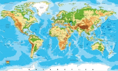
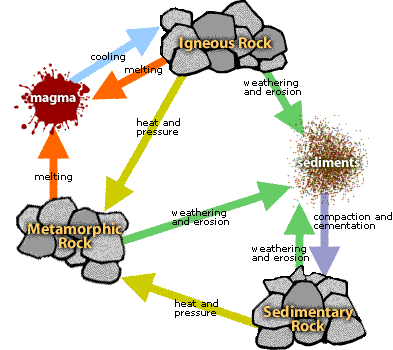
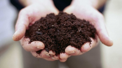
Soil is the layer of loose material between the surface and the solid rock below the ground.  Chances are that you haven't thought a lot about the soil under your feet, but you may be surprised at the complexity of soil. Soil varies in its composition and the structure of its particles, and these factors are closely examined by farmers, who need appropriate soil for planting crops, as well as engineers who may need to understand how soil is going to hold up under different demands. Soil is also vitally important to the sustainability of an ecosystem because it serves as the natural medium for the growth of vegetation. Nothing can grow on Earth without it, but the soil varies in different places.


Grasses:


The soil is rich in nutrients, so many grasses can grow healthy and quickly.  They are an important source of food for man; they play an important ecological role in nature; and they are good protectors of the soil against soil erosion. The greatest value of grass is perhaps the role that grass plays in stabilizing and protecting the soil and for this reason the grass family is probably the most important plant family on earth.


Long roots:


Trees and grasses have long roots that go deep down to collect as much water as possible from the soil. Roots grow through the whole life of the plant. They grow longer from the tip, adding cells to the end of each root. The root adds cells to their tips, and they grow fatter as they add cells around their tube-like bodies.


At the tip of each root, there is a small group of tough, dead, hard cells called the root cap. The root cap is the strongest part of the root tip, and its job is to push its way through the dirt to look for moisture and nutrients and protect the plant.


Dung beetle:


These creatures feed on and break up, or decompose, animal poo, adding nutrients to the soil. Dung beetles aerate and mix the soil by burrowing, and increase the organic matter content of the soil by burying dung. These changes improve the water holding capacity and nutrient availability of the soil, with associated benefits to plants. By burying dung, they also provide an important food source for decomposers, and reduce resources for the larvae of economic insect pests such as bushflies


Leafcutter ants:


Ants dig tunnels into the soil, letting in air and moving around decaying plants and animals, which add nutrients to the soil. Leaf-cutting ants modify soil fertility through two mechanisms. First, the building, enlargement, and maintenance of nests ants affect soil structure, porosity and density. Second, leafcutters collect and concentrate vegetal material inside their nests to maintain their fungus culture, the food for most of the colony. As a result of this process, ants generate a huge quantity of organic waste that is deposited in nest cavities or dumps on the soil surface.


Buttress roots:


Trees have shallow roots underground to quickly take in the water and nutrients in the topsoil. Most rainforest soil is very poor with all the nutrients available largely remaining at surface level. Because of this rainforest trees have very shallow roots. 


Some very tall trees have developed ways of obtaining much needed additional support by forming buttressed roots, which grow out from the base of the trunk sometimes as high as 15 ft above the ground. These extended roots also increase the area over which nutrients can be absorbed from the soil.


Forest floor:


Many leaves from the thick tree canopy fall to the dark forest floor and decay. The major compartments for the storage of organic matter and nutrients within systems are the living vegetation, forest floor, and soil. The forest floor serves as a bridge between the above ground living vegetation and the soil, and it is a crucial component in nutrient transfer through the biogeochemical cycle. Much of the energy and carbon fixed by forests is periodically added to the forest floor through litterfall, and a substantial portion of the nutrient requirements of forest ecosystems is supplied by decomposition of organic matter in the forest floor and soil surface. 


Autumn leaves:


As the weather gets cooler and the days get shorter in the fall, trees start to prepare for winter. Trees use sunlight to make a special layer or seal between each leaf and the branch it is connected to. Then the leaves fall easily to the ground, leaving the branches of the tree protected from the cold that will come in the winter and also helping the tree store up food!


Since leaves have water inside their cells, they can’t survive freezing temperatures, because the water would freeze and the leaves would die. When leaves fall to the ground, they eventually break down and provide nutrients for the soil, helping prepare for more plants to grow in the spring and also create a layer that helps the ground absorb water.


Earthworm:


Earthworm burrows alter the physical structure of the soil. They open up small spaces, known as pores, within the soil. When earthworms are introduced to soils devoid of them, their burrowing can lead to increases in water infiltration rates of up to 10 times the original amount. This brings water and soluble nutrients down to plant roots. Burrowing also improves soil aeration (important for both plants and other organisms living in the soil) and enhances plant root penetration.


Tree roots:


Tree roots absorb nutrients and water from the soil. Large roots anchor the tree into the ground to prevent it from blowing over in the wind. Most roots live just 6-12 inches below ground and extend far beyond the width of the tree’s canopy. Cutting tree roots can cause stress to a tree and can leave it vulnerable to disease or insect attack. Roots need oxygen. By allowing soil to dry for several days between watering, oxygen can make its way to the roots. Avoid piling new soil or compacting the ground underneath the tree. This can suffocate the roots that absorb oxygen close to the surface. 


 Cactus:


Cacti have shallow roots and thick stems, so they can collect and store water. Cacti can have many small, thin roots near the top of the soil. These roots take in water quickly after a rain. The same cactus may have one long, thick root called a taproot. The taproot grows deep in the soil. It can reach water when the soil on top is dry.


Deep roots:


Desert trees have very long roots to reach down and collect water from deep underground. There are several benefits to a deep root system rather than a large surface root system. A deep root system helps the plants stay grounded in the soil through harsh winds and other adverse conditions. And the plant is not dependent on rainfall to get water for survival.


Kangaroo rat:


When burrowing, animals break down large rocks, mix up the soil, and let air into it. Kangaroo rats play an important in the ecological communities in which they live. Specifically, they influence plant growth by feeding on and dispersing seeds and digging burrows in the soil. This contributes to the overall health of their ecosystem. They are also prey for numerous predators, including barn owls, burrowing owls, snakes, and coyotes. In order to help keep ecosystems healthy, we have worked with our partners to translocate kangaroo rats out of areas that are slated for development and into appropriate habitat on protected reserves.


Grassland:


The soil is usually deep and full of nutrients. This is because rotting grass roots help to hold the soil together and add nutrients for new plants. Plants compete for water. Grasslands occur in environments conducive to the growth of this plant cover but not to that of taller plants, particularly trees and shrubs. The factors preventing establishment of such taller, woody vegetation are varied.


Tropical rainforest:


The soil is very wet and many plants grow, so there is lots of humus to add nutrients to the soil. However, these nutrients are washed away by the constant rain, leaving shallow, acidic soil. Most tropical rainforest soils relatively poor in nutrients. Millions of years of weathering and torrential rains have washed most of the nutrients out of the soil. More recent volcanic soils, however, can be very fertile. Tropical rain forest soils contain less organic matter than temperate forests and most of the available nutrients are found in the living plant and animal material. Nutrients in the soil are often in forms that are not accessible by plants.


Constant warmth and moisture promote rapid decay of organic matter. When a tree dies in the rainforest, living organisms quickly absorb the nutrients before they have a chance to be washed away. When tropical forests are cut and burned, heavy rains can quickly wash the released nutrients away, leaving the soil even more impoverished. 


Temperate deciduous forest:


The soil is moist and full of nutrients from decaying plants and animals, especially in autumn. The deep roots of plants break up the bedrock, which adds minerals. Water often drains through steadily.

The soil of deciduous forests is classified as an alfisol or a brown forest soil.  It is very nutrient rich. This is caused by the large leaf fall during the fall seasons.  When the snow melts in the spring the leaves on the ground decompose and supply the nutrients that the plants need to grow.  This type of soil was considered the most fertile type of soil until the modern inventions allowed other types of soil to be modified.


Desert:


The soil is very dry and few plants grow, so there is little humus. It is made up of boulders, pebbles, and sand, and is blown around by the wind. Any water drains through the sand easily. Deserts soils are generally of brown, light brown or reddish color. Due to arid conditions, leaching of soil is almost absent in the desert soils and thus evaporation is quite rapid.


Therefore, these soils are in general saline. Further in some low level areas, the salt content in the desert soil is really high. In fact, it is so high that common salt is obtained by evaporating the saline water collect from such areas.


However, salt content in some desert soils is not that high and thus in such cases they support vegetation in the sufficient availability of water. Moreover, in some areas land is rocky and is surrounded by gravel.


Picture Credit : Google