Your parents would advise you against sharing your location with strangers. But back then, scientists thought it would be a good idea to reach out to aliens by sending out a map to locate our Sun and thereby Earth. What’s this map like? in space, no one can find you using coordinates such as north, south, east or west. That’s why American astronomer Frank Drake came up with the Pulsar Map. And two of these maps are currently aboard Voyager 1 and 2 probes, which are sailing through the interstellar space. The maps are inscribed on the Golden Record that the probes carry. The records contain sounds and images selected to portray the diversity of life and culture on Earth, intended for any intelligent extraterrestrial life for that may find them.
How does it work?
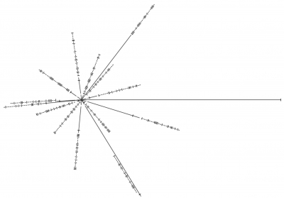
The pulsar maps on the Voyager probes pinpoint the location of the Solar System with respect to 14 pulsars.
Pulsars are the rapidly spinning remains of dying stars – the leftover cores of supernova explosions. They emit narrow beams of light. Each pulsar has its own signature pulse rate, thus easily identifiable, and ideal as reference points on a map.
Frank Drake’s map has each pulsar connected to the Sun by a solid line. The length of the line represents the pulsars approximate relative distance from the Sun. Along those distance markers are inscribed the pulsars’ spin rates in binary code. By decoding the map, extraterrestrial intelligence can calculate the time frame of the spacecraft’s launch and also the position of the Sun.
Picture Credit : Google