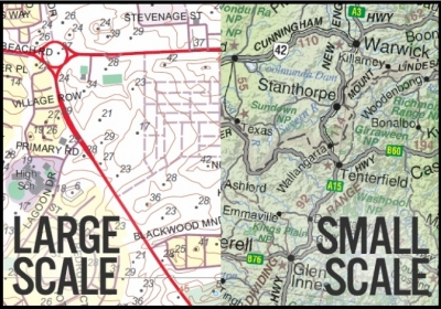
On are made small enough to fit on paper. The scale of a map is the difference between the map size and the real size. When a map is drawn to scale, everything is made smaller by the same amount. A large-scale map shows a small area with lots of details. It is what you would see if you were looking down on an area from too close. The motorways, streets, parks, and buildings would look large.
A small-scale map shows a large area with not many details. It is what you would see if you were looking down on an area from very far away. You might see main roads, large towns, and rivers or mountains. The roads and towns would look small.
Map projections are a mathematical model for converting locations on the earth’s surface from spherical to planar coordinates, allowing flat maps to depict three-dimensional features. Some map projections preserve the integrity of shape, others preserve accuracy of area, distance or direction. All map projections distort shape, area, distance or direction to some extent.
On large scale maps, such as street maps, the distortion caused by the map projection being used may be negligible because your map will typically cover only a small part of the Earth’s surface.
On smaller scale maps, such as regional and world maps, where a small distance on the map may represent a considerable distance on the Earth, this distortion may have a bigger impact, especially if the application involves comparison of the shape, area or distance of different features. In these cases, knowledge of the characteristics of the map projection you are using becomes more important.
Picture Credit : Google


